Vietnam
Dong Nai, Vietnam — Towns & Travel Guide


Đồng Nai spreads east of Ho Chi Minh City, a province of the Đồng Nai River, Trị An reservoir and the forests of Cát Tiên.
About Dong Nai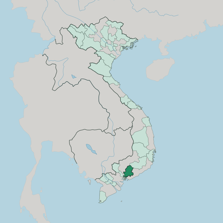


Towns & cities in Dong Nai
Pick a town or city — each links to where to stay.
Most beds cluster in Biên Hòa, the riverside hub where the province's business and history concentrate. Choose it as a first base. Travellers chasing forest trade the city for lodges at the Nam Cát Tiên gate, or for stilt homestays scattered along the shores and islands of Trị An Lake.
Closer to Ho Chi Minh City, hotels are thickening around the Long Thành airport site. Beyond Biên Hòa and the reservoir, rooms thin out fast.
About Dong Nai
What is Dong Nai known for?
Đồng Nai is Vietnam's industrial engine, a belt of factories and rubber estates ringing Biên Hòa beside Ho Chi Minh City. Nature balances the machinery. Cát Tiên National Park shelters golden-cheeked gibbons, wild gaur and elephants across some of the last lowland rainforest in the country, while the dammed Đồng Nai River pools into Trị An Lake, an island-studded reservoir.
Long Thành, the international airport rising in the south, will route much of the traffic bound for Ho Chi Minh City. Forest, river and runway sit side by side.
Where is Dong Nai?
Đồng Nai sits just east of Ho Chi Minh City, at the heart of the Đông Nam Bộ, the Southeast region that forms Vietnam's economic core. It has no coastline. The land climbs gently inland, from flat alluvial plains around Biên Hòa to low hills and red basalt uplands further from the city, where rubber and cashew plantations take over.
When the province absorbed neighbouring Bình Phước in 2025, its territory stretched north all the way to the Cambodian border, so the modern province runs from the fringe of Ho Chi Minh City to the frontier forests near Cambodia. Its neighbours are Ho Chi Minh City to the southwest and the highlands of Lâm Đồng to the northeast. The province takes its name from the Đồng Nai River, the longest river that runs entirely within Vietnam.
It threads through Biên Hòa on its way to the sea below Ho Chi Minh City, gathering the La Ngà and other tributaries along the route. Upstream, engineers dammed it in 1987 to create Trị An Lake, the largest reservoir in the country's south, whose islands and drowned valleys supply water and power to the metropolis downstream. Northeast of the lake, the lowland rainforest of Cát Tiên National Park spreads across the boundary between Đồng Nai and Lâm Đồng.
Water defines the province more than any ridge.
What is Dong Nai like?
Đồng Nai wears two faces. Along the river it is old and mercantile: Cù Lao Phố, the islet at Biên Hòa, was one of the busiest trading ports in the south during the 17th and 18th centuries, settled by Chinese refugees who fled the fall of the Ming. Their kilns founded a craft that still defines the place.
Biên Hòa's glazed stoneware, fired in villages along the Đồng Nai River, blended Vietnamese, Chinese and French Limoges techniques and carried off medals at the Paris exhibitions of 1925 and 1933. Learning was honoured here too, at the Văn miếu Trấn Biên, the first Temple of Literature built in the country's south, in 1715. Away from the river the character shifts.
The uplands that came from Bình Phước are plantation country, where Xtiêng, Chơ Ro, Nùng and Khmer communities live among the cashew groves, rubber estates and pepper gardens. Catholic parishes founded by northern migrants cluster around Hố Nai, their churches lining the old highway. Long Khánh is known across the region for its longan and rambutan orchards.
Vietnamese is the shared language, but this is a working province at heart, where factory towns, fruit farms and forest villages sit within an hour of one another. It labours as much as it welcomes.
What is the history of Dong Nai?
Vietnamese rule dates from 1698, when the lord's envoy Nguyễn Hữu Cảnh set up the Trấn Biên garrison and drew this bend of the Đồng Nai River into the realm. Biên Hòa grew rich on the Cù Lao Phố trade. That wealth collapsed when the Tây Sơn armies sacked the port and its merchants fled downriver toward Saigon.
France seized the town in 1861. Its air base later became one of the largest the Americans flew from during the war that followed independence. In 2025 neighbouring Bình Phước rejoined Đồng Nai, reuniting the old Trấn Biên lands.
What is the climate of Dong Nai?
Đồng Nai runs hot all year, in the tropical monsoon belt that shapes the country's south. Two seasons split the calendar. The wet monsoon sweeps in from the southwest between May and November, when afternoon downpours swell the Đồng Nai River and refill Trị An Lake behind its dam.
From December to April the dry season takes over, hazy and warm, with the rains stalled. The plantation uplands toward Bình Phước run a touch cooler and wetter than the plains around Biên Hòa. Umbrellas earn their keep here.
How do you get to Dong Nai?
Most travellers still land at Tân Sơn Nhất in Ho Chi Minh City and drive east, roughly an hour along the expressway that links the two. That is set to change. Long Thành, the international airport rising near the town of the same name, is built to funnel most of the region's overseas arrivals straight into the province.
The main North-South railway threads through Biên Hòa on its run from Hanoi to Ho Chi Minh City, and National Route 1 carries the road traffic. From Ho Chi Minh City, Đồng Nai is barely an hour off.
Good for
Updated July 2026