Argentina
Tucumán Province, Argentina — Towns & Travel Guide


Tucumán is Argentina's smallest mainland province, where the Andes drop into sugarcane plains and the 1816 independence oath was signed.
About Tucumán Province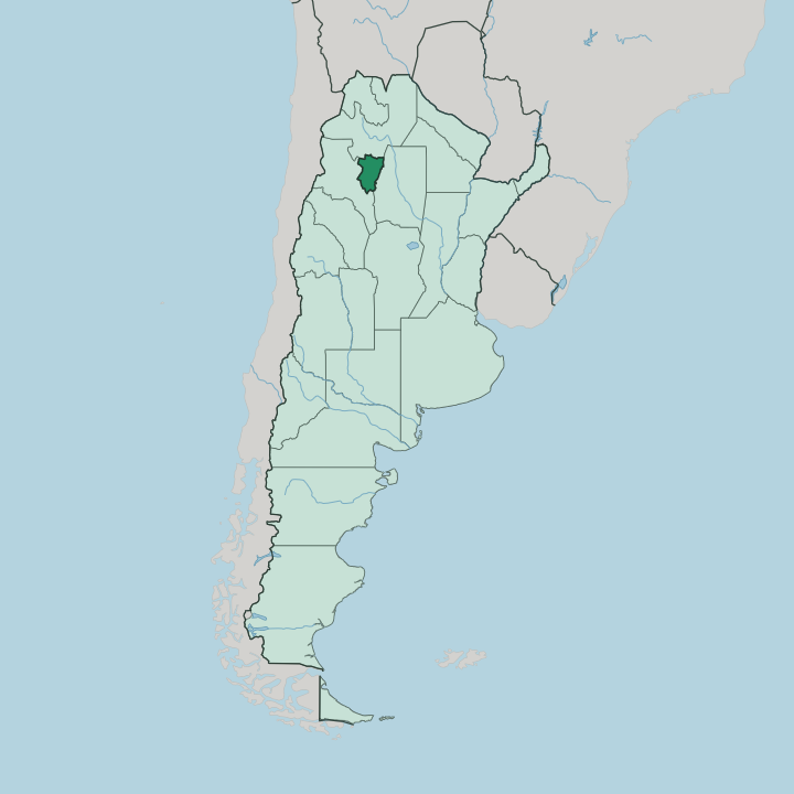
Towns & cities in Tucumán Province
Pick a town or city — each links to where to stay.
San Miguel de Tucumán is the natural first base, set around Plaza Independencia and within a short walk of the Casa Histórica where the 1816 declaration was signed. Most trips begin there. From the city a road winds up through the de los Sosa gorge to Tafí del Valle, a cool town in the mountains where people go to escape the lowland heat.
Further west the land opens into the dry Calchaquí Valleys, near the Ruins of Quilmes, the largest pre-Columbian settlement uncovered in the country. Beds thin out fast once you leave the valley towns. Stay in the capital for history and transport; head to Tafí del Valle or the Calchaquí Valleys when you want the high, dry side of the province.
About Tucumán Province
What is Tucumán Province known for?
Argentines call it El Jardín de la República, the Garden of the Republic. The name fits. Sugarcane, lemons, and tobacco carpet the warm eastern plains, fed by rain the Sierra del Aconquija wrings from the easterly winds.
Its capital, San Miguel de Tucumán, holds the small colonial house where deputies signed the country's declaration of independence on July 9, 1816. West of the city the land climbs fast into cloud forest and dry Andean valleys, and the contrast between the green lowland and those high ridges is what most visitors come to see.
Where is Tucumán Province?
Tucumán sits in the northwest of Argentina, the second-smallest of the country's provinces and the most densely settled. Salta borders it to the north, Santiago del Estero to the east, and Catamarca to the south and west. Two very different landscapes meet inside those borders.
The east belongs to the flat, fertile edge of the Gran Chaco, alluvial plain laid down by rivers and given over to cane and citrus. The west rises into the Sierra del Aconquija, a chain of outlying Andes ridges whose highest summit, the Cerro del Bolsón, tops 5,000 metres. Between the two runs the Salí, the province's main river, gathered behind the El Cadillal dam north of the capital and feeding the irrigation that makes the lowland green.
The mountains do the crucial work. Their eastward faces catch the moist easterly winds and pull heavy rain from them, which is why the lower slopes carry dense Yungas cloud forest while the valleys behind, in the rain shadow, stay dry and brown. Cross the Cumbres Calchaquíes into the Calchaquí Valleys and the air turns thin and arid within a single day's drive.
Small province, sharp extremes. Few places in Argentina pack this much variety into so little ground, from tropical plain to bare Andean rock in under a hundred kilometres.
What is Tucumán Province like?
Sugar shaped Tucumán, and it still runs through everything here. The mills that spread after the railway reached the province in 1876 built its towns, its fortunes, and its music, and the annual cane harvest, the zafra, gave the region a folk songbook of its own. Zambas like De Simoca, born of that harvest, are sung across the province and far beyond it.
Food carries the same weight as song. The empanada tucumana, filled with knife-cut beef, cumin, and paprika and eaten with a squeeze of lemon, is claimed here as the country's finest, and Tucumanos will argue the point at length. Spanish is the everyday language, threaded with Quechua words left by the Andean peoples who lived in these valleys long before the cane.
That older world is still visible. In the town of Simoca, the National Capital of the Sulky, the Saturday fair fills with horse-drawn carts and country produce, the oldest fair of its kind in the country. Craft runs strong in the hills too, where weavers along the routes around Tafí del Valle still work wool by hand and press the sharp local cheese the town is known for.
Old and rural, loud and proud of it.
What is the history of Tucumán Province?
Diego de Villarroel founded San Miguel de Tucumán in 1565, and the city moved to its present site by the Salí in 1685. Its defining moment came two centuries later. In 1816 deputies from the provinces gathered in a modest house in the city and declared the independence of the United Provinces of South America from Spain, the act that founded the Argentine state.
Long before either date, the Calchaquí Valleys held the Diaguita towns whose stone terraces still stand at the Ruins of Quilmes, abandoned after the Spanish forced its people out in 1667.
What is the climate of Tucumán Province?
Tucumán is warm and wet where most people live. The eastern plain has a humid subtropical climate, with hot, storm-heavy summers and mild winters that keep the cane and citrus growing. Rain comes off the easterly winds and piles up against the Sierra del Aconquija, drenching the lower slopes and the Yungas forest that cloaks them.
Climb west past the ridges and the pattern flips: the Calchaquí Valleys sit in the rain shadow, dry and cool, and mountain towns like Tafí del Valle stay crisp when the lowland swelters. Two climates, one small province.
How do you get to Tucumán Province?
For most travellers to Tucumán the journey ends at the airport gate. The Benjamín Matienzo airport sits a short way east of San Miguel de Tucumán and takes daily flights from Buenos Aires, roughly a two-hour hop across the country. Long-distance buses also run up from Buenos Aires and link the province to Salta and the rest of the Argentine northwest.
From the capital a mountain road climbs west through the de los Sosa gorge to Tafí del Valle and the Calchaquí Valleys beyond. It is the usual mountain route.
Good for
Updated July 2026