Argentina
Entre Ríos Province, Argentina — Towns & Travel Guide


Entre Ríos is the Argentine province held between the Paraná and Uruguay rivers, its name meaning "between rivers."
About Entre Ríos Province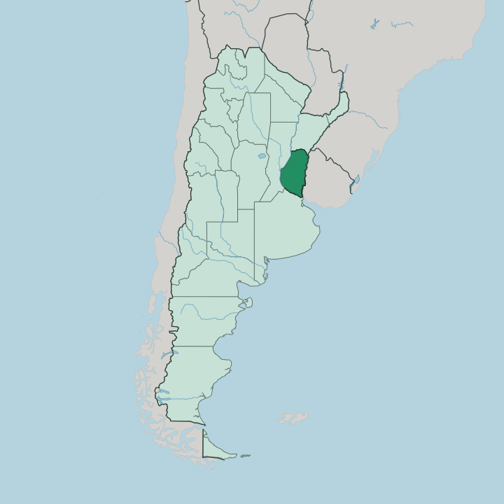
Towns & cities in Entre Ríos Province
Pick a town or city — each links to where to stay.
Paraná, the capital, is the natural first base, its bluffs and riverside parks facing Santa Fe across the Paraná River. Along the Uruguay side the towns line up by their draws. Colón pairs thermal baths with the palm groves of El Palmar National Park; Gualeguaychú throws the country's longest Carnival each summer; Concordia sits amid the citrus belt beside the Salto Grande dam.
Pick your river. Stay in Paraná for the capital and the western shore, or choose a town on the Uruguay River when you want hot springs, sand beaches and easier reach into the country of Uruguay just across the water.
About Entre Ríos Province
What is Entre Ríos Province known for?
Two great rivers give the province its name and its reputation. The Paraná runs down its western and southern edge, the Uruguay marks the eastern border with the country of Uruguay, and the land between them is the Argentine Mesopotamia. Water defines everything here.
Hot springs draw the crowds, with mineral thermal complexes at Colón, Concordia and Federación that made Entre Ríos the thermal heartland of Argentina. The capital is Paraná, on the river of the same name across from Santa Fe. Fishing, riverside beaches and the febrile Carnival at Gualeguaychú fill out the rest.
Where is Entre Ríos Province?
Entre Ríos sits in central-eastern Argentina, the southern lobe of the region called the Argentine Mesopotamia. It is an island of land bounded by moving water on almost every side. The Paraná River wraps its western and southern edge, and the Uruguay River forms the whole eastern boundary with the country of Uruguay.
Corrientes lies to the north, and Buenos Aires spreads to the south. Water is the frontier. Only a short land border to the north, along the Guayquiraró and Mocoretá streams, keeps the province from being a true island.
The interior is not flat. Two low ranges of rolling hills, the cuchillas, run the length of the province and part around the Gualeguay River that drains the middle of it southward. Toward the Paraná in the west and south the land breaks into the marshes, channels and wooded islands of the great river delta.
That delta is one of the largest wetland systems anywhere in South America, a maze of low islands where the Paraná splits into dozens of arms before reaching the sea. The two national parks sit at these edges: El Palmar guards yatay palm savanna beside the Uruguay River, and Predelta protects the islands where the Paraná begins to fan out near Diamante.
What is Entre Ríos Province like?
Life here bends toward the water. Weekends run on riverside asados, mate passed around the shade of a ceibo tree, and long afternoons on the sand beaches that line both the Paraná and the Uruguay. The province was a federalist stronghold, and it still carries the memory of Justo José de Urquiza, the caudillo who ruled it from his Palacio San José and took the whole confederation with him.
That politics left a proud, provincial identity distinct from Buenos Aires. Spanish is the language. What sets Entre Ríos apart is who else settled its fields, because waves of Volga German, Jewish and Italian immigrants founded farming colonies across the centre, leaving Lutheran churches, kosher histories and dialect villages among the criollo towns.
Gualeguaychú answers the winter with its Carnival. Through the hot months its Corsódromo runs the longest Carnival season in the country, feathered comparsas and thunderous batucada drawing crowds from across Argentina. Fishing is a way of life along both rivers, the dorado prized above all.
Food follows the water too: river fish, citrus from the northern groves, and the blood sausage and strudel of the immigrant kitchens all sit on the same table.
What is the history of Entre Ríos Province?
Entre Ríos became a province in its own right in 1814, carved from the old riverine territories. Its towering figure is Justo José de Urquiza, governor and caudillo, who defeated Juan Manuel de Rosas at Caseros in 1852 and drew the country toward a federal constitution. For a spell the young Argentine Confederation ran its affairs from Paraná, which served as national capital through the late 1850s while Buenos Aires stood apart.
Urquiza built his Palacio San José near Concepción del Uruguay and was assassinated there in 1870. That federalist inheritance still shapes the province.
What is the climate of Entre Ríos Province?
Entre Ríos has a humid subtropical climate, warm and green, with rain spread through the year and no real dry season. Summers are hot and sticky. Heat builds over December and January, when the river towns and their beaches fill and the Gualeguaychú Carnival runs its nights.
Winters stay mild rather than cold, frost rare away from the open camp, and the rivers keep the air moist the whole year round. Rain is heaviest toward the north and the Uruguay River side.
How do you get to Entre Ríos Province?
Most visitors come overland from Buenos Aires, a few hours south by road across the Paraná delta. The province has its own airport at Paraná with flights from the capital, and Concordia adds another in the north. Bridges do the heavy lifting.
The Zárate-Brazo Largo bridges carry the main road up from Buenos Aires, while three international crossings over the Uruguay River link Colón, Concepción del Uruguay and Concordia to the country of Uruguay on the far bank. Once inside, a good highway grid connects the river towns.
Good for
Updated July 2026