Brazil
Alagoas, Brazil — Towns & Travel Guide


Alagoas is a small state on Brazil's Northeast coast, known for coral-reef beaches, the São Francisco river, and its two lagoons at Maceió.
About Alagoas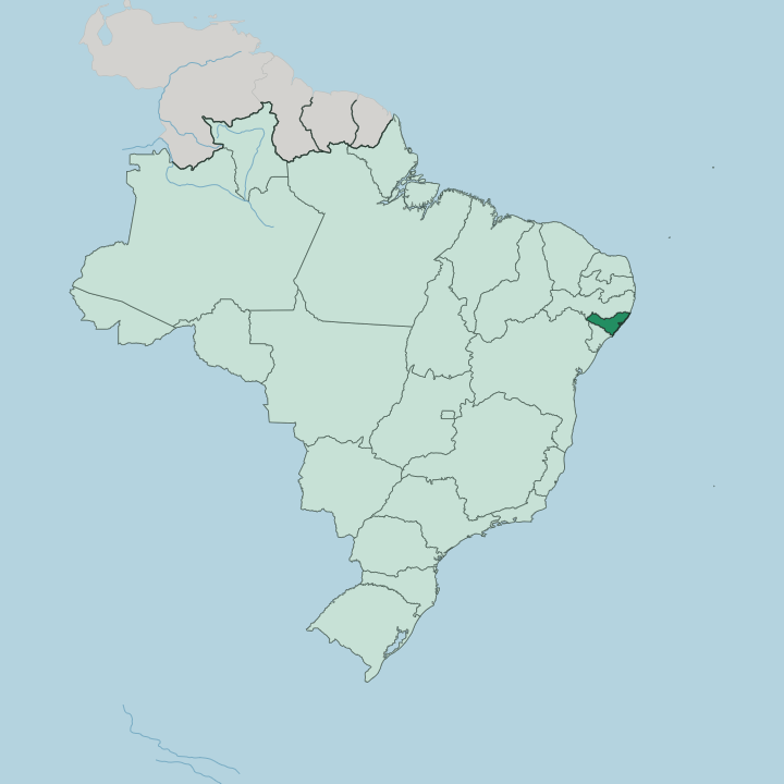
Towns & cities in Alagoas
Pick a town or city — each links to where to stay.
Most trips base in Maceió, the capital, strung along a beachfront of Pajuçara, Ponta Verde, and Jatiúca where the calm reef water sits close in. Head north for the coast. The Costa dos Corais runs up to Maragogi, where boats cross at low tide to the galés pools, while quieter São Miguel dos Milagres keeps to coconut groves and small pousadas.
South, the colonial river port of Penedo stands above the São Francisco. Start in Maceió before venturing out.
About Alagoas
What is Alagoas known for?
Alagoas is the second-smallest state of Brazil, packed onto a narrow strip of the Northeast coast. Beaches carry the fame. The Costa dos Corais, a line of fringing reefs running north from Maceió toward Maragogi, shelters shallow natural pools that fill with clear water at low tide.
Maceió, the capital, fronts the Atlantic beside the Mundaú lagoon, where the sururu shellfish that defines the local kitchen is gathered. Inland the land climbs into sugarcane country and dry caatinga scrub. Reefs, lagoons, and cane.
Where is Alagoas?
Alagoas sits on the Atlantic coast of the Northeast of Brazil, the second-smallest of the country's states after neighbouring Sergipe. Pernambuco wraps its northern and western sides. The São Francisco river, the great waterway of the Brazilian Northeast that locals call the Velho Chico, forms the whole southern border, dividing Alagoas from Sergipe before it empties into the Atlantic. Bahia touches the far southwest. The coast itself runs for a couple of hundred kilometres of white sand, broken by river mouths and backed by a line of fringing coral reef offshore.
Two shallow lagoons, Mundaú and Manguaba, open behind Maceió and give the state its name, since Alagoas means the lakes. Behind the shore, Alagoas rises through three bands. The zona da mata, a belt of humid green hills, was cleared for sugarcane and still carries most of the crop.
West of it lies the drier agreste, a transition of mixed farming around Arapiraca, the state's second city and its tobacco and produce hub. Beyond that the land opens into the sertão, semi-arid backcountry of thorny caatinga scrub where rain is scarce and drought a fact of life. The highest ground stands in that far interior.
It is a compact state, easy to cross, yet it holds coast, cane, and dry backland within a short drive of each other.
What is Alagoas like?
The culture of Alagoas grew out of the sugar estates and the people brought to work them. Africa runs through it. Its most famous story is Palmares, the great community of escaped enslaved people that held out for most of the seventeenth century in the forested hills of the interior, led in its last years by Zumbi.
Serra da Barriga, the ridge above União dos Palmares where the settlement stood, draws people for pilgrimage and remembrance. That inheritance shows in the music and the faith. Coco, a call-and-response song and dance of African root, is sung across the state, and Christmas brings out guerreiro and reisado troupes in the towns.
Everyday life is quieter than that history. The kitchen centres on the lagoons: sururu, a small mussel raked from the mud of Mundaú, is cooked with coconut milk and eaten with rice across Maceió. Along the same shore, women in Marechal Deodoro knot renda filé, an openwork lace stretched on frames, a craft passed down through the old colonial town that was the first capital of the state.
Alagoas is sometimes called the land of the marshals, since Deodoro da Fonseca and Floriano Peixoto, the first two men to lead the Brazilian republic, were both born here. Portuguese is the language. It is a proud place, poor in parts, and deeply attached to its saints, its songs, and its coast.
What is the history of Alagoas?
Alagoas began as sugar country in the Portuguese captaincy of Pernambuco, its coastal forest cleared for cane in the sixteenth century. Palmares rose in the same backlands. The quilombo of escaped enslaved Africans resisted colonial armies for decades before its main settlement was crushed in 1694, and Zumbi, betrayed in hiding, was hunted down and killed in 1695.
Alagoas broke away from Pernambuco to become a captaincy of its own in 1817, and a province of imperial Brazil after that. It became a state when the republic replaced the monarchy in 1889. Cane shaped all of it.
What is the climate of Alagoas?
Alagoas splits into two climates. The coast around Maceió is hot and humid the year round, cooled by the Atlantic trade winds, with its heaviest rain falling in the southern-hemisphere autumn and winter from about April to July. Push inland and the rain thins fast.
The sertão of the interior is semi-arid, hot and dry, and prone to long droughts that can hold the caatinga brown for months. Days stay warm everywhere. The difference is water, not heat.
How do you get to Alagoas?
Nearly everyone arrives through Maceió. Its airport, named for the Palmares leader Zumbi, takes flights from São Paulo, Rio de Janeiro, and the other big Brazilian cities, plus a handful from abroad. Many travellers instead fly into Recife, the larger hub up the coast in Pernambuco, and drive down the BR-101 highway.
That road is the coastal spine, threading Alagoas from the Sergipe line in the south to Pernambuco in the north. Buses run it too. The beaches then spread on either side.
Good for
Updated July 2026