Brazil
Ceará, Brazil — Towns & Travel Guide


Ceará is a state on the northeastern coast of Brazil, its capital Fortaleza on the Atlantic and a dry sertão filling the interior.
About Ceará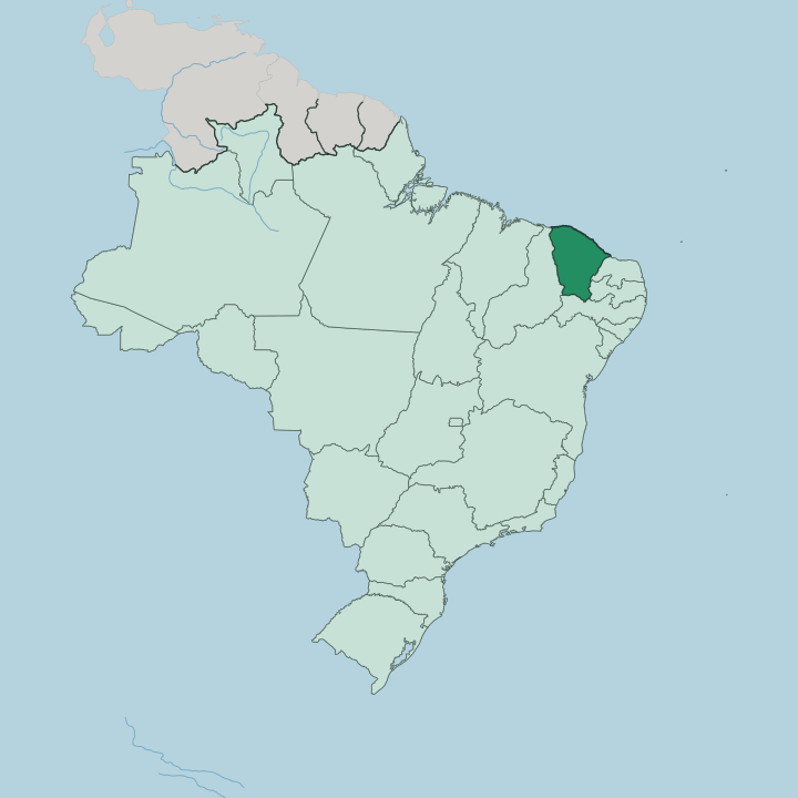
Towns & cities in Ceará
Pick a town or city — each links to where to stay.
Most first trips start in Fortaleza. The capital sits on the Mucuripe headland, and its Beira-Mar seafront puts hotels, the fish market and the beaches of the north coast within one stretch. The named beaches lie further out.
Jericoacoara hides behind the dunes of the northwest, while Canoa Quebrada caps the red cliffs near the mouth of the Jaguaribe. Inland, the Cariri valley below the Chapada do Araripe draws pilgrims to Juazeiro do Norte. Pick the base to fit the coast.
About Ceará
Ceará sells sun and coastline.
What is Ceará known for?
Fortaleza is the capital and the point most trips begin, a large coastal city that opens onto more than 570 kilometres of Atlantic beaches. The beaches carry the fame. Jericoacoara draws the dunes-and-lagoon crowd in the northwest, while Canoa Quebrada shows off red sandstone cliffs to the east.
Inland the land dries into the sertão, the semi-arid backcountry that shaped forró, cordel poetry and the jangada sailing rafts still worked off the shore. The state exports comedians, too.
Where is Ceará?
Ceará occupies the northeastern shoulder of Brazil. The Atlantic runs along its northern edge, while Piauí lies to the west, Pernambuco to the south, and Rio Grande do Norte to the east across the dry interior. It is the seventeenth-largest state.
Its coastline stretches more than 570 kilometres, a near-continuous run of beach, dune and headland facing the ocean. Behind the shore the land climbs into a low interior plateau, most of it under 300 metres. This backcountry is the sertão.
Thorny caatinga scrub covers much of it, a semi-arid vegetation of twisted trees and cactus that greens briefly after the rains and greys again through the long dry months. Uplands rim the state on almost every side. The Chapada do Araripe forms the southern boundary with Pernambuco, a flat-topped plateau rising near 900 metres, while the Serra da Ibiapaba walls off Piauí along the west.
One river dominates the map. The Jaguaribe rises in the southern hills and runs north across the sertão to the Atlantic, seasonal and often reduced to pools before the rains refill it. Fortaleza holds the north coast.
What is Ceará like?
Ceará lives loudly. Forró, the accordion-and-triangle music of the Northeast, fills the June festivals of São João, when whole towns dance the quadrilha in squares strung with paper flags. On the coast, fishermen still sail the jangada, a flat wooden raft that has become the emblem of the whole shore.
Women in the coastal villages still work renda de bilro, the bobbin lace threaded on pillows and sold along the beaches. The language is Portuguese. Inland the tradition shifts, to cordel poetry booklets hawked at market fairs and the woodcut prints that illustrate their covers.
Cattle shape the backcountry too, and the leather-clad vaqueiro of the sertão rides in the vaquejada round-ups that still draw crowds. Faith is everywhere. Nowhere more than Juazeiro do Norte, where pilgrims climb to the hilltop statue of Padre Cícero, the priest the sertão still reveres as its own saint.
Ceará also sends comedians across the whole country, a run of them out of Sobral and Fortaleza. Renato Aragão, the clown of Brazil's long-running Trapalhões troupe, was born in Sobral. Humour is a local export.
What is the history of Ceará?
Fortaleza grew from a fort. The Dutch raised Fort Schoonenborch on the coast in 1649, and after the Portuguese retook it in 1654 they renamed it for Our Lady of the Assumption, the seed of the capital. Ceará broke free of Pernambuco's rule to become a province in 1799.
Its proudest date came in 1884, when Ceará abolished slavery four years ahead of the rest of Brazil. Raftsmen had blockaded the Fortaleza port to slave ships three years before. The state itself dates to 1891.
What is the climate of Ceará?
Ceará is hot and dry. The coast stays warm all year, cooled by a steady onshore trade wind that draws kitesurfers to Cumbuco and Jericoacoara, while the sun rarely goes missing for long. Rain falls mainly between February and May, heaviest on the seaboard and the mountains.
The sertão gets far less, and periodic drought has driven waves of migration off the land. The backlands live by the rains.
How do you get to Ceará?
Fortaleza is the way in. Pinto Martins International Airport sits about 8 kilometres south of the centre and takes the international and domestic flights that carry most travellers into the state. A smaller airport at Jericoacoara serves the beaches of the northwest coast directly.
Long-distance buses link Fortaleza with the rest of the Northeast, and paved highways run down the coast and inland to the Cariri. The last stretch to Jericoacoara crosses sand.
Good for
Updated July 2026