Brazil
Goiás, Brazil — Towns & Travel Guide


Goiás is Brazil's Central-West heartland: a high Cerrado plateau of thermal springs, colonial gold towns, and the canyons of Chapada dos Veadeiros.
About Goiás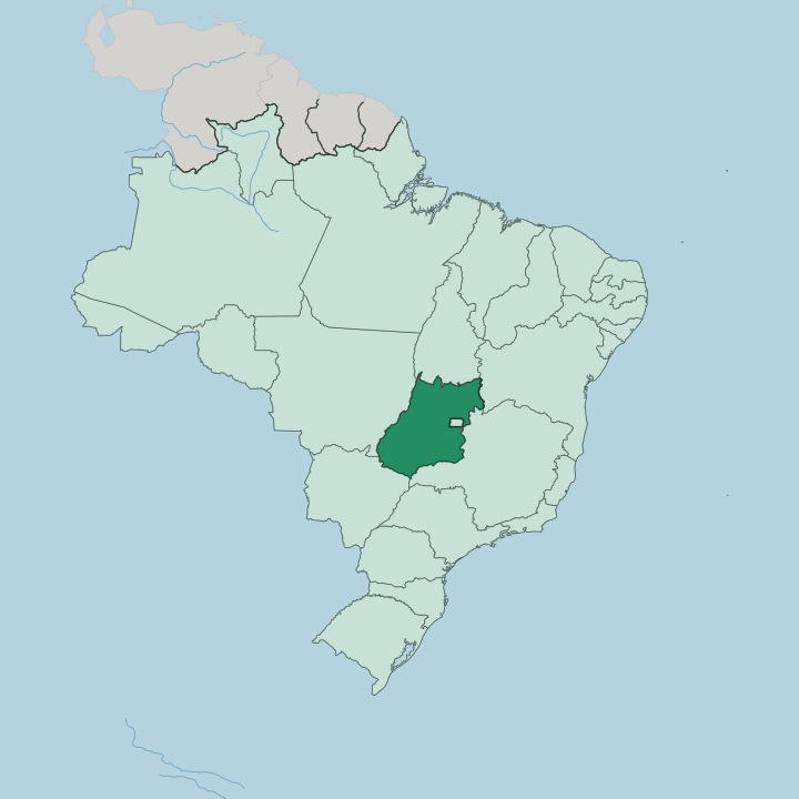
Towns & cities in Goiás
Pick a town or city — each links to where to stay.
Goiânia is the obvious first base, a planned capital of broad avenues and the heartland of Brazilian sertanejo music. The state fans out from there. Caldas Novas, to the south, sits over a field of naturally heated groundwater and is given over to thermal resorts.
Pirenópolis stages the Cavalhadas below the Serra dos Pireneus. Trails climb north into Chapada dos Veadeiros from Alto Paraíso de Goiás. Choose Goiás Velho, the former colonial capital on the Rio Vermelho, when whitewashed churches and cobbled lanes matter more than the thermal pools.
About Goiás
Goiás is farm country and hot-spring country at once.
What is Goiás known for?
Its plateau grows much of Brazil's soybeans and sugarcane, and Goiânia, the planned capital, anchors an agribusiness economy that reaches across the Central-West. Travellers come for something older and stranger. Caldas Novas holds one of the world's largest fields of naturally heated groundwater, drawing bathers to its thermal pools.
Northward, the quartz plateau of Chapada dos Veadeiros breaks into waterfalls and canyons. The colonial gold town of Goiás Velho survives almost intact.
Where is Goiás?
Goiás sits on the Planalto Central, the high tableland at the core of Brazil. Its surface is a rolling plateau of red earth and Cerrado savanna, most of it standing between 600 and 900 metres above the lowlands. The land rises to quartzite ridges in the north, where Chapada dos Veadeiros lifts above the surrounding plain.
Gallery forests trace the rivers, but open savanna covers the ground between them. Rivers cut it in every direction. The state is a watershed.
Its streams feed three of the continent's great basins at once. Northward, the Araguaia River and the Tocantins River gather the runoff and carry it toward the Amazon lowlands. The Araguaia traces the state's long western edge against Mato Grosso, while the Tocantins forms in the Goiás highlands.
To the south, the Paranaíba River drains toward the Paraná and the distant River Plate. In the far south-west, the flat grasslands of Emas National Park run toward the Mato Grosso do Sul line. Goiás wraps almost entirely around the Federal District, the enclave that holds Brasília, and borders Tocantins, Bahia, Minas Gerais, Mato Grosso do Sul and Mato Grosso.
The capital, Goiânia, stands in the south of the state. No coast reaches here.
What is Goiás like?
Country music runs through Goiás. The sertanejo sound, born in the rural interior, fills the bars of Goiânia and pours from sound systems at the annual agricultural fairs. Catholic devotion is the older current here.
In Goiás Velho, torch-lit Holy Week processions called the Procissão do Fogaréu wind through the streets after dark, a rite kept since colonial times. Pirenópolis holds the Festa do Divino, and with it the Cavalhadas, three days of costumed horsemen re-enacting battles between Moors and Christians. The pageant is loud, medieval, and unmistakably goiano.
Its table is just as distinct. Pequi, a golden Cerrado fruit with a sharp perfume and a hidden spine, flavours the local rice, arroz com pequi, that no visitor forgets. Cooks steam pamonha from fresh green corn and simmer galinhada, a saffron-yellow pot of chicken and rice, over slow wood fires.
Guavas cook down into the paste called goiabada. Much of this belongs to the wider Brazilian sertão, but Goiás claims it as its own. The colonial core survives in Goiás Velho and the cobbled lanes of Pirenópolis, where whitewashed walls and Baroque churches still frame daily life.
What is the history of Goiás?
Gold brought the first towns. In the 1720s bandeirantes led by the pathfinder Anhanguera struck gold in the streams of the plateau, and the mining camp of Vila Boa, later the city of Goiás Velho, rose to become the capital of a new captaincy. The seams ran out within a century, and Goiás turned to cattle and crops across its plateau.
It joined the Brazilian republic as a state in 1889. In 1933 the government began building an entirely new capital, and by 1937 the seat of power moved to the planned city of Goiânia.
What is the climate of Goiás?
Goiás has two seasons, not four. The wet months, from October to March, bring heavy afternoon storms that turn the Cerrado deep green and swell the rivers. Then the taps shut off.
A long dry season runs from April to September, when the sky clears, the air dries out, and dust and grass fires drift across the plateau. The high ground keeps the heat in check, so evenings on the tableland stay mild even in the warm months. Dry-season skies are the clearest, the usual window for hiking Chapada dos Veadeiros.
How do you get to Goiás?
Most travellers to Goiás come by air. Most flights land at Santa Genoveva Airport on the edge of Goiânia, linking the state capital with São Paulo, Rio de Janeiro and other Brazilian cities. International arrivals often use Brasília instead.
Its larger airport lies within reach of the state, a short drive across the Federal District line into Goiás. From there the highways take over. The BR-153 highway runs the length of the state, and buses fan out from Goiânia to Pirenópolis, Caldas Novas and the trailhead towns below Chapada dos Veadeiros.
Updated July 2026