Brazil
Rio Grande do Norte, Brazil — Towns & Travel Guide


Rio Grande do Norte is Brazil's northeastern corner, a Potiguar coast of white dunes and warm Atlantic beaches anchored by its capital, Natal.
About Rio Grande do Norte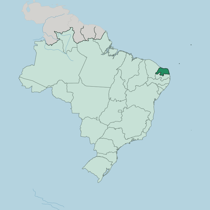
Towns & cities in Rio Grande do Norte
Pick a town or city — each links to where to stay.
Most trips start in Natal, where the beach quarter of Ponta Negra sits beneath the sandy hump of the Morro do Careca and the old Forte dos Reis Magos guards the mouth of the Potengi. The coast then turns to cliffs. Pipa hangs above dolphin bays near Tibau do Sul.
North of the Potengi lie the buggy dunes of Genipabu, where dromedaries plod the sand. Inland, Mossoró rules the salt flats and oilfields. Base yourself in the capital first.
About Rio Grande do Norte
Sun and salt define this state.
What is Rio Grande do Norte known for?
Its coast runs for more than 400 kilometres, and buggies climb the shifting dunes of Genipabu while dolphins gather below the red cliffs of Pipa Beach near the surf village of Tibau do Sul. Natal frames most of it, a capital of dune parks and the long crescent of Ponta Negra beneath the Morro do Careca. Salt pans and offshore oil rigs share the same shoreline.
Steady trade winds turn the sky an unusually clear blue.
Where is Rio Grande do Norte?
Rio Grande do Norte holds the corner of Brazil, the point where the country's Atlantic coast stops running north and swings west along the top of South America. That pivot is Cape São Roque, the northeasternmost tip of South America, a short way up the shore from Natal. The state belongs to the Northeast Region of Brazil. Ceará lies along its western border and Paraíba to the south, while the Atlantic Ocean wraps the whole northern and eastern edge.
The Potengi river cuts down to the sea through Natal, and its wide mouth gave the state its name of Great Northern River. Offshore sits Rocas Atoll, the only atoll in the South Atlantic. White-sand beaches and dunes run for some 400 kilometres.
Inland, the green ends fast. Most of the state is sertão, a semi-arid backcountry of thorny caatinga scrub that browns in the long dry season. The Chapada do Apodi, a low limestone plateau, rises along the frontier with Ceará.
Rivers here run only after rain, filling and emptying with the sky. Near Mossoró and the port of Areia Branca the flats turn to salt pans that supply much of Brazil's sea salt, worked beside the derricks of the country's onshore oilfields. Coast and sertão could hardly look less alike.
What is Rio Grande do Norte like?
People here call themselves Potiguar, after the coastal tribe the Portuguese found in the sixteenth century. The name is said to mean shrimp-eater. Portuguese is the everyday language, carried on a soft northeastern accent.
Music means forró above all, an accordion-and-triangle dance born of the sertão and loudest each June, when São João bonfire parties fill Mossoró and the villages inland. Natal answers in December with Carnatal, a carnival held out of its usual season behind trucks of drummers. Faith threads the calendar too; the capital's very name means Christmas, and its old fort honours the Three Wise Men.
The table is built on salt and sun. Carne de sol, beef salted and dried in the open air, is the dish everyone claims. At the Redinha market in Natal, cooks fold tiny fried ginga fish into hot tapioca.
Cashew grows in every yard, and a single sprawling tree at Pirangi covers ground enough for a small orchard of its own. Daily life leans on the beach and the buggy, on fishing rafts called jangadas, and on the salt pans and oil rigs that pay the bills. Sea, sand and wind set the rhythm.
What is the history of Rio Grande do Norte?
Vespucci's ships named the coast in 1501, calling the Potengi's broad mouth the Great River. The Potiguar tribe held the land. French brazilwood traders worked the shore for decades until Portugal raised the Forte dos Reis Magos in 1598 and founded Natal on Christmas Day the year after.
The captaincy became a state in 1891. Its strangest chapter came in the Second World War, when the United States built Parnamirim Field outside Natal and staged aircraft across the Atlantic to Africa; Roosevelt called it the Trampoline to Victory.
What is the climate of Rio Grande do Norte?
Two climates split the state. The coast around Natal is humid tropical, warm through the year with its rain falling mostly between autumn and midwinter. Push inland and the air dries into semi-arid sertão, where showers are sparse and some years barely come.
Southeast trade winds blow hard and steady off the Atlantic, sculpting the dunes and spinning rows of wind turbines on the ridges. Skies stay bright and clear. The heat is even rather than fierce, tempered on the shore by that constant sea breeze.
How do you get to Rio Grande do Norte?
Nearly everyone arrives by air at Natal, whose international airport sits just west of the city at São Gonçalo do Amarante. Flights connect through the larger Brazilian hubs, and charter routes have long tied the coast to Europe. Overland, paved highways drop south from Fortaleza in Ceará and climb up from Recife past the Paraíba border, the two nearest big cities with airports of their own.
From Natal the coast road runs south to the cliffs of Pipa. Buggies take over for the Genipabu dunes.
Good for
Updated July 2026