Democratic Republic of the Congo
Mai Ndombe, Democratic Republic of the Congo — Towns & Travel Guide


Mai Ndombe wraps a vast blackwater lake and Congo Basin swamp forest in western Democratic Republic of the Congo.
About Mai Ndombe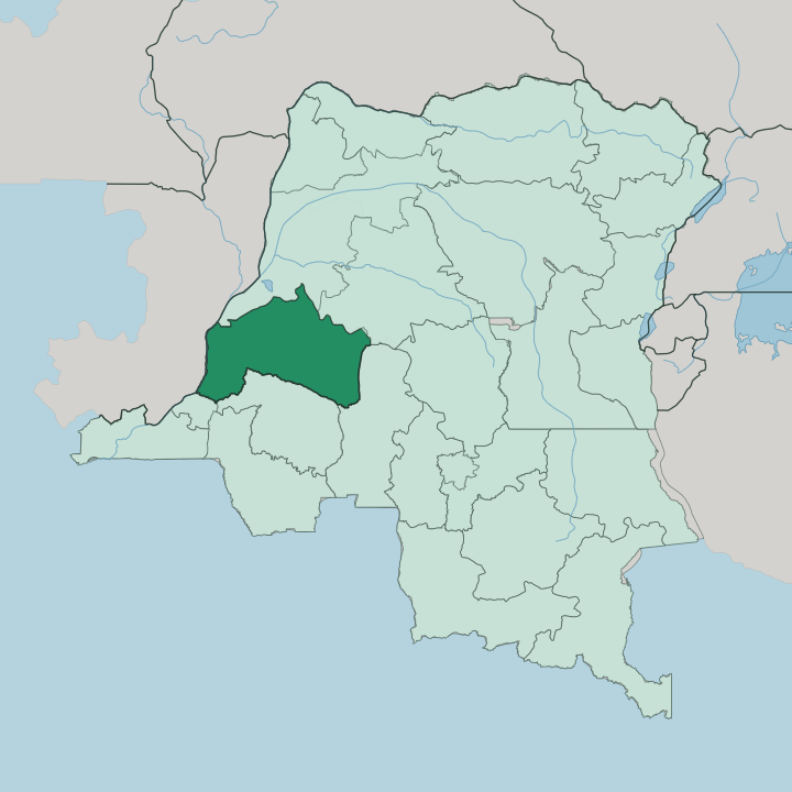


Towns & cities in Mai Ndombe
Pick a town or city — each links to where to stay.
Inongo is the natural base. The capital holds the province's port and its airport on the eastern shore of Lake Mai-Ndombe, and it offers the widest choice of beds in a region where formal lodging is genuinely scarce. Elsewhere you stay in river towns.
Nioki sits on the Fimi where barges from Kinshasa unload, Kutu trades cassava and palm oil between the lake and the river, and Bolobo is an old station on the Congo River facing the Republic of the Congo. Choose Inongo for the lake and the port. Choose the smaller towns only if the water route itself is the point of the trip.
About Mai Ndombe
What is Mai Ndombe known for?
The province takes its name from Lake Mai-Ndombe, and the lake defines everything here. Its name means black waters. Dark tannins leached from the surrounding peat swamp stain it the colour of strong tea, and the lake swells to double or triple its size when the rains come.
Around it stretches the Congo Basin rainforest, some of the least disturbed lowland forest left in the world. Bonobos and forest elephants live in that forest. Inongo, the capital, sits on the eastern shore and serves as the main port.
Where is Mai Ndombe?
Mai Ndombe fills a low wetland basin in western Democratic Republic of the Congo, north-east of the capital at Kinshasa. Lake Mai-Ndombe lies at its heart. The lake runs roughly a hundred and thirty kilometres from end to end and reaches forty kilometres across at its widest, yet it is shallow throughout, five metres deep on average and rarely more than ten.
It is a blackwater lake, its dark tint drawn from tannins in the peat and swamp forest that ring it. In the rains the shoreline vanishes as the lake spreads far into the surrounding forest, doubling and sometimes tripling in area before it draws back. Water carries the province.
The lake drains south into the Lukenie River, which becomes the Fimi below the outflow, and the Fimi runs on to join the Kasai and finally the Congo River. To the west the province meets the Republic of the Congo across the Congo itself. Équateur and Tshuapa lie to the north, Kasaï to the east, and Kwilu and Kinshasa to the south. Roads are few and often impassable in the wet season, so the lake and its rivers do the work that highways do elsewhere.
What is Mai Ndombe like?
Life in Mai Ndombe is organised around the water and the forest, not around roads. Many peoples share the province. The Mongo and the Bateke are among the larger groups, alongside the Basakata, the Basengele, the Baboma and the Bayanzi, and the forest is also home to Batwa communities who have lived in it far longer than any state has drawn a border across it.
French is the official language, but it sits atop a wider web of local tongues used in the markets and the villages. Fishing feeds families and trade alike on a lake this rich. The forest shapes daily life as much as the lake does.
Cassava and palm oil move down the rivers toward Kinshasa, and dried fish travels the same routes in the other direction. The great swamp forest that surrounds the lake is one of the largest carbon stores on earth, and the bonobos that live only in the Democratic Republic of the Congo make this one of their strongholds. That has drawn conservation projects and the money that follows them.
Wells and schools in towns like Kutu and Nioki have been paid for out of forest-carbon revenue. It is a remote province, and its culture is bound tightly to the river, the fish and the trees.
What is the history of Mai Ndombe?
Mai Ndombe first existed as a province between 1962 and 1966, before it was folded into the larger Bandundu Province. It came back in 2015. That year the national repartitioning broke Bandundu apart into Kwango, Kwilu and Mai Ndombe, and the lakeside town of Inongo was raised to capital of the revived province.
The lake had lent the province its name long before either arrangement, and the fishing villages along its shores are older still than any of the lines drawn on a map.
What is the climate of Mai Ndombe?
Heat and moisture hold over Mai Ndombe in every season. Most of the province has a tropical savanna climate, with a marked wet season and a drier stretch, while the north-east shades into monsoon and true rainforest conditions where the Congo Basin forest thickens. The rains govern the calendar.
When they arrive, Lake Mai-Ndombe spreads far into the forest and the rivers rise, and the difference between water and land blurs across the whole basin. Humidity stays high whatever the month.
How do you get to Mai Ndombe?
Most travel begins in Kinshasa. From the capital a river route runs up the Congo, into the Kasai and the Fimi, and on to Inongo on Lake Mai-Ndombe, a journey of about two days by boat. Inongo also has a small airport with limited flights, which is the fast way in.
Roads exist but turn to mud in the rains. Once you reach the lake, the wooden passenger ferries and barges that link Inongo, Kiri and the river towns are how nearly everyone moves around the province.
Good for
Updated July 2026