Algeria
Wilaya de Khenchela, Algeria — Towns & Travel Guide


Wilaya de Khenchela is the Aurès heartland of north-east Algeria: cedar-clad peaks around Djebel Chélia giving way to desert-edge steppe.
About Wilaya de Khenchela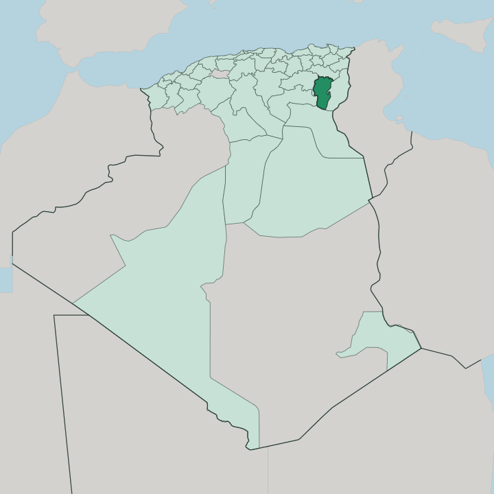


Towns & cities in Wilaya de Khenchela
Pick a town or city — each links to where to stay.
Khenchela city is the practical base, the old Roman Mascula below the northern mountains and the hub for most of the province. Choices thin out beyond it. West of the capital, the spa town of El Hamma keeps the Roman baths of Hammam Essalihine running, their pools still fed from the same hot spring.
Higher west, the Aurès rises to Djebel Chélia. Cedar forests and stone hamlets ring Bouhmama, the mountain district holding the highest ground in the range. The far south is another country: steppe and date oases along the Oued El Arab, thinly settled and hours from the northern peaks.
About Wilaya de Khenchela
Two landscapes define Khenchela.
What is Wilaya de Khenchela known for?
The north rises into the Aurès, the rugged massif where Djebel Chélia stands as the highest peak of the range and the second-highest summit in all Algeria. South of the mountains the land dries into steppe and pre-Saharan plain, roughly half the province by area. The Chaoui Berbers have held these valleys for millennia.
Rome left its stamp too, clearest at Hammam Essalihine, a thermal bath near the capital whose pools have run hot since antiquity.
Where is Wilaya de Khenchela?
Khenchela sits in the north-east of Algeria, deep in the Aurès region, roughly six hundred kilometres south-east of Algiers. It shares its borders with five other provinces. Batna lies to the west and Oum el Bouaghi to the north; Tébessa closes it off to the east, while Biskra and El Oued open onto the desert to the south. The province was carved out of Oum el Bouaghi and Tébessa in 1984.
Its jagged shape follows the grain of the mountains and the wadis that cut through them. The land splits cleanly into two. The northern and central-western reaches are all mountain, the high Aurès massif, where Djebel Chélia rises above the cedar forests as the tallest peak of the range and the second-highest in the country.
Snow settles on those heights in winter. South of the ridges the ground falls away into steppe and pre-Saharan plain, which makes up nearly half the province, drained by the Oued El Arab as it runs down toward the sands. The capital stands high in the north, well over a kilometre up, on the mountain side of that divide.
What is Wilaya de Khenchela like?
The Aurès is Chaoui country, and Khenchela sits at its heart. The Chaoui are a Berber people rooted in these mountains, herders and farmers who have worked the high valleys for as long as anyone can trace. Their language is Shawiya, a Berber tongue the Chaoui call Tachawit, still spoken in the villages alongside Arabic.
Wool weaving, the burnous, red-earth pottery and the terraced gardens of the mountain douars belong to the same old way of life. Music and poetry carry it too. That identity is bound up with resistance.
The Aurès has thrown back army after army, Roman and Byzantine and Arab, and the seventh-century queen Dihya, remembered as the Kahina, made her last stand against the Muslim conquest somewhere in these hills. The Romans left their own mark on the ground: the capital stood as their Mascula, a garrison town holding the empire's southern edge, and their frontier ran on through these passes. Layers stack up here.
A Berber highland laid over a Roman floor, carrying a warrior's memory besides, the province wears all of it at once.
What is the history of Wilaya de Khenchela?
Khenchela began as Mascula, a Roman town on the southern frontier of the empire, and the baths at Hammam Essalihine date from that age. Rome faded; the Aurès did not. In the seventh century the Berber queen Dihya, the Kahina, fought the advancing Muslim armies from these mountains.
Long after, the modern town took shape under French rule: the army reached Khenchela in 1850, settlers followed from 1878, and the railway arrived in 1905. The Aurès around Khenchela was among the first regions to rise when the war of independence broke out in 1954. The province itself was drawn in 1984.
What is the climate of Wilaya de Khenchela?
Height rules the weather here. Up in the Aurès, Khenchela keeps a warm-summer Mediterranean climate and ranks among the coldest towns in Algeria: winters are chilly and damp, snow whitens Djebel Chélia and the high ground, and rain falls mostly in the cold months. Summers turn warm and dry.
Cross south of the mountains and the pattern breaks; the steppe and the pre-Saharan plains are hotter, browner and far drier, edging toward true desert along the fringe with Biskra. Most of the year's modest rain lands on the northern peaks.
How do you get to Wilaya de Khenchela?
Khenchela has no airport of its own. The usual approach is to fly into Batna, west across the Aurès, where Mostépha Ben Boulaïd Airport connects to Algiers, then drive the mountain roads east into the province. Tébessa, to the east, offers a second airport within reach.
From Algiers, far to the north-west, it is a long haul overland, the better part of six hundred kilometres by road. Once inside, everything runs on the roads that thread the Aurès and drop south toward the desert. Buses link the capital with Batna and the coast.
Good for
Updated July 2026