Algeria
Wilaya de Tébessa, Algeria — Towns & Travel Guide


Wilaya de Tébessa is a province of eastern Algeria: Aurès highlands and phosphate country holding the Roman ruins of Theveste.
About Wilaya de Tébessa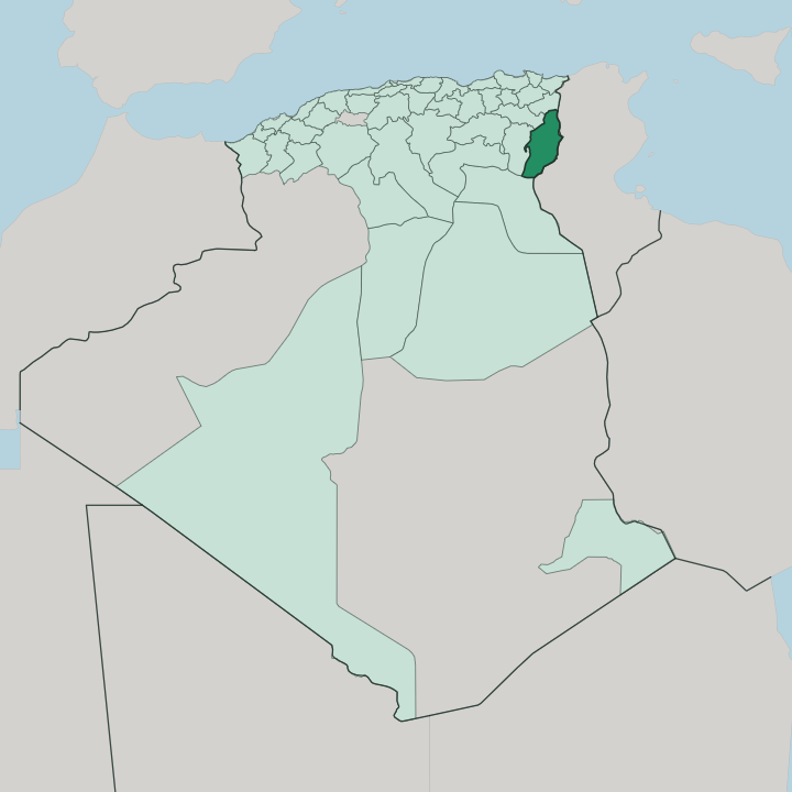


Towns & cities in Wilaya de Tébessa
Pick a town or city — each links to where to stay.
Base yourself in Tébessa. The capital's Centre Ville sits inside the ring of Solomon's Byzantine walls, a short walk from the Arch of Caracalla and the basilica of Saint Crispina, and it holds most of the province's hotels and cafés. Southward, Bir el Ater is the mining town nearest Djebel Onk and the desert edge, useful if you are tracing the phosphate country or the Aterian sites.
Ouenza, wrapped around its red iron mountain in the north, and Chéria, out on the cereal plateau, suit travellers who want the working interior rather than the ruins.
About Wilaya de Tébessa
Tébessa is Roman and Byzantine ground.
What is Wilaya de Tébessa known for?
The provincial capital was Theveste, and the Arch of Caracalla, the Temple of Minerva, and the Byzantine walls raised by the general Solomon still frame its old core. Beyond the ruins, the province is mining country: phosphate is dug at Djebel Onk near Bir el Ater in the south, and iron ore at Ouenza in the north. The Aurès and Nemencha highlands roll across the rest, grazed by Chaoui shepherds and woven into the kilims that carry the town's name.
Where is Wilaya de Tébessa?
Wilaya de Tébessa fills the far eastern corner of Algeria, pressed against the frontier with Tunisia. The provincial capital lies barely a dozen miles west of that border, and roughly 235 kilometres inland from the Mediterranean port of Annaba. This is high country.
Most of the province rides the Hauts Plateaux, the broad steppe tableland that runs along the eastern end of the Aurès Mountains, and the town of Tébessa itself stands well above the plain under the ridge of Djebel Doukkane. The Nemencha range carries the same folded limestone south-east into Tunisia. Everything tilts as the land goes south.
Around Bir el Ater and Negrine the plateaus break down toward the northern Sahara, dry and stony, where the phosphate ridge of Djebel Onk rises from the desert margin. Rainfall thins in the same direction. The north is different again: at Ouenza and El Aouinet the ground crumples into iron-bearing hills near the Tunisian line.
Rivers here are seasonal wadis, not permanent streams, and they run only after the winter rains. Across the whole wilaya, from steppe and ridge to the desert edge, water and altitude decide what grows and where people settle.
What is Wilaya de Tébessa like?
This is Chaoui country. The Aurès and its eastern spurs are the homeland of the Chaouïa, the Berber people whose Tachawit speech still runs alongside Arabic in the markets of Tébessa and the villages of the Nemencha. Herding shaped the culture.
The Nemencha tribes long moved their flocks with the seasons, wintering on the plateaus around Tébessa and drifting south toward the Souf in the dry months, and that pastoral rhythm still marks the calendar of festivals, weddings and weekly souks. Dress, song and cooking carry the same highland stamp. The Tunisian border a few miles east keeps the dialect and the cooking close to what is heard across the line.
Wool is the province's signature craft. Tébessa gives its name to a school of hand-knotted carpets and flat-woven kilims, geometric in pattern and coloured with the reds and ochres of the highlands, still sold in the old town's covered market. Under all of it lies a deep Christian and Roman memory.
Saint Crispina was martyred at Theveste in the year 305, and her great basilica drew pilgrims long before the Arabic-speaking dynasties arrived. Faith, wool and the herd: three threads of one Chaoui inheritance.
What is the history of Wilaya de Tébessa?
Tébessa's story is one of the deepest in Algeria. Prehistory itself was named here. The Aterian stone-tool culture is called after Bir el Ater in the south, where knapped points tens of thousands of years old were first identified.
Carthage held the site, then Rome made it Theveste and stationed the Third Augustan Legion here before the legion moved west to Lambaesis. Trajan raised it to a colony, Caracalla gave it the triumphal arch that still spans the old road in 214, and the Byzantine general Solomon walled the town in 535 with thirteen square towers.
What is the climate of Wilaya de Tébessa?
Tébessa sits too high and too far inland for a Mediterranean climate. The classification is cold semi-arid, the weather of open steppe. Summers run hot and dry, and the plateau bakes for months under a hard, cloudless sun that pushes afternoon heat toward its yearly peak.
Winters bite. Frost is common on the uplands, snow settles on the Aurès and Nemencha ridges some years, and the little rain the province gets, a few hundred millimetres, falls mostly in the cold months. The far south around Bir el Ater is drier and hotter still, shading into true desert as the land falls toward the Sahara.
How do you get to Wilaya de Tébessa?
Tébessa lies a long way inland, and most arrivals come overland. Cheikh Larbi Tébessi Airport, on the edge of the city, carries the main air link to Algiers. The trunk road climbs up from the port of Annaba, some 235 kilometres to the north-west, shadowed by the rail line first laid to move phosphate and iron ore.
Tunisia is close. The frontier crossing sits only a short drive east, which puts the Tunisian interior nearer than most of Algeria. Buses and shared taxis tie Tébessa to Bir el Ater, Ouenza and Chéria.
Good for
Updated July 2026