Hungary
Nógrád megye, Hungary — Towns & Travel Guide


Nógrád is Hungary's least populous county, a wooded upland on the Slovak border where the Palóc kept their villages, weaving, and dialect alive.
About Nógrád megye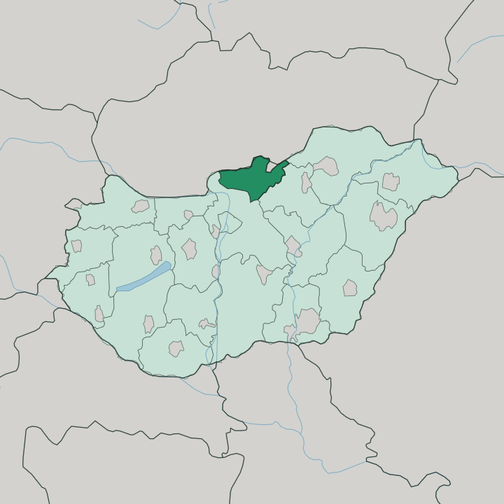
Towns & cities in Nógrád megye
Pick a town or city — each links to where to stay.
Base yourself by what you have come to see. Most travellers stay in or near Hollókő, where guesthouses in the old village put you inside the World Heritage streetscape. Salgótarján, the county seat, has the most rooms and works as a base for the volcanic country and Salgó Castle to its north.
Balassagyarmat, the former seat, sits out west on the Ipoly, a quiet town for the river and the Palóc museum. Beds thin out fast beyond these three. Book the Hollókő guesthouses well ahead for the Easter festival, when the village fills.
About Nógrád megye
What is Nógrád megye known for?
Nógrád fills the northern edge of Hungary, pressed against the border with Slovakia. It is the country's least populous county. Three mountain ranges reach into it, the Cserhát, the Börzsöny, and the Mátra, leaving small villages scattered through wooded valleys.
The Palóc live here, a Hungarian group whose weaving, embroidery, and dialect give the county its distinct grain, seen best in the World Heritage village of Hollókő. Salgótarján anchors the county in the north-east, a coal town turned county seat.
Where is Nógrád megye?
Nógrád occupies the far north of Hungary, and the Ipoly river draws much of its boundary with Slovakia. That river runs west along the frontier for a good stretch before turning south to the Danube. Three ranges of the North Hungarian Mountains crowd the county.
The Börzsöny rises in the west, the Cserhát fills the centre, and the Mátra climbs along the eastern edge toward the county's highest ground. Between them lie narrow valleys, and the villages sit in those valleys rather than on open plain. Salgótarján, the county seat, stands in the north-east at the foot of Karancs, a peak straddling the line with Slovakia.
Balassagyarmat lies west of it, on the Ipoly itself. The land is volcanic in the north-east. Basalt columns and old lava caps mark the Medves country around Salgó Castle, and the Ipolytarnóc fossil beds preserve a subtropical forest turned to stone. Budapest sits about two hours south by road.
Little of Nógrád is flat, and less of it is far from a ridge.
What is Nógrád megye like?
Nógrád is the heartland of the Palóc, and their culture sets the county apart from the rest of Hungary. The Palóc dialect, with its distinctive vowels, is still heard in the villages. Their embroidery and weaving are known nationwide.
Nowhere shows this better than Hollókő. The Old Village of Hollókő, a cluster of whitewashed timber-and-daub houses beneath a hilltop castle, was placed on the UNESCO World Heritage list in 1987 as a rare survival of pre-industrial village life. Its Easter festival, when women wear the full Palóc costume, draws visitors from across the country.
Faith runs through the calendar here. Wooden bell-towers and small baroque churches stand in villages that have kept their saints' days and pilgrimages, and the chapel below Karancs remains a place of Marian pilgrimage. Folk music and craft markets fill the summer.
The county wears its traditions plainly, in daily use rather than behind museum glass.
What is the history of Nógrád megye?
The county grew up around the medieval fortress of Nógrád, organised under Stephen I as the Hungarian kingdom first took shape. Its castles guarded the Ipoly valley. They held against the Mongols and, generations later, against the advancing Ottomans.
Salgó Castle, raised by the Kacsics clan on a volcanic crag in the 13th century, is the best-known of them. Borders redrew the county in the 20th century. The Treaty of Trianon handed its northern third to Czechoslovakia after the First World War, cutting Palóc communities apart across a new frontier.
Then coal remade Salgótarján. Mining pulled the county's weight north-east and turned a market district into an industrial town.
What is the climate of Nógrád megye?
Nógrád has a continental climate, drier and more sharply seasonal than western Hungary. The warmth arrives with summer across Nógrád's hills. The hills hold snow through cold winters, and the higher ground of the Mátra and the Börzsöny keeps a white cover longer than the valleys below.
Spring and autumn are the settled seasons for walking the ridges and castle hills. Rain falls more on the uplands than on the sheltered valley floors. Frost lingers in the hollows.
How do you get to Nógrád megye?
Nógrád keeps no airport. Most visitors fly into Budapest and drive north from the capital, reaching Salgótarján in about two hours on the road that threads up through the Cserhát hills. A rail line follows the same corridor to Salgótarján and on to Balassagyarmat.
Trains run slower than the road. From Slovakia, bridges over the Ipoly tie the county to the towns on the northern bank. Inside Nógrád, a car is the only practical way to reach the scattered villages, since Hollókő and the mountain castles sit well off the trunk routes.
Good for
Updated July 2026