India
State of Arunāchal Pradesh, India — Towns & Travel Guide


Towns & cities in State of Arunāchal Pradesh
Pick a town or city — each links to where to stay.
Itanagar is the practical base, the capital and largest town, and the place most trips through the state begin and end. Beyond it, distance dictates everything. Tawang holds the biggest cluster of guesthouses in the mountainous far north-west, close to its Gelug monastery.
Ziro puts you among the Apatani paddy fields, where homestays in wooden houses are the usual bed. Bomdila breaks the long climb toward Tawang with hotels at ridge height. Choose Itanagar if you want an easy first night off the plains; choose Tawang, Ziro or Bomdila when the point of the trip is the high country itself.
About State of Arunāchal Pradesh
This is the wildest corner of north-east India.
What is State of Arunāchal Pradesh known for?
Tribal country. More than a hundred communities share the state, from the Buddhist Monpa around Tawang to the Apatani rice farmers of the Ziro valley, and the Nyishi spread across its central hills. The Siang, the Himalayan headwater of the Brahmaputra, carves the land in two before it drops toward Assam.
Itanagar sits below the mountains as the capital, and Tawang Monastery crowns the far north-west as the largest Gelug monastery in India.
Where is State of Arunāchal Pradesh?
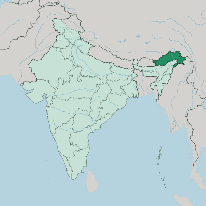
Arunāchal Pradesh fills the north-eastern tip of India, the state that reaches furthest into the eastern Himalayas. Bhutan closes it off to the west. Along the north and north-east runs the long contested frontier with the Tibet Autonomous Region of China, and Myanmar meets it in the south-east, so three international borders wrap the state on almost every side.
Only in the south does it open onto the rest of India, dropping to the plains it shares with Assam and, in one south-eastern corner, with Nagaland. The land itself is nearly all mountain. Ridges climb from the Assam lowlands through foothills into the Great Himalayas, and Kangto, the highest summit in the state, rises above seven thousand metres near the Tibetan edge.
Deep valleys cut between the ranges. Through them runs the Siang, the name the Brahmaputra carries here after it turns south out of Tibet, gathering the Subansiri, the Kameng, the Dibang and the Lohit before all of it pours down into the Assam plain. Water and altitude, more than any map line, decide how the state is settled.
What is State of Arunāchal Pradesh like?
No other Indian state is so finely divided by tribe. More than a hundred communities live here, and among them the Nyishi are the most numerous, spread across the central districts. Each has kept its own tongue.
Most belong to the Tani branch of the Tibeto-Burman languages, and the count of distinct speech across the state runs past fifty, which is why a shared lingua franca matters more here than almost anywhere else in India. Belief splits along the mountains. In the north-west the Monpa follow the Gelug school of Tibetan Buddhism, and Tawang Monastery anchors their calendar and their villages alike.
Elsewhere many tribes hold to Donyi-Polo, an indigenous faith that worships the sun and the moon and reads spirits into rivers, ridges and trees. The Apatani of Ziro farm rice and fish together in the same flooded paddies, a system old enough and careful enough to sit on UNESCO's watch list. Festivals mark the farming year rather than a single national calendar.
Dress, house-building and craft change from one valley to the next. What holds across all of it is a plain fact of geography: these are hill peoples, and the hills kept them distinct.
What is the history of State of Arunāchal Pradesh?
For most of the twentieth century this was frontier ground, not a state. It carried a bureaucrat's name. Governed from afar as the North-East Frontier Agency, the territory was run first through India's foreign ministry and only later brought under home administration.
The renaming came in 1972, when the agency became the union territory of Arunāchal Pradesh, and full statehood followed on 20 February 1987, making it one of the last pieces of north-east India to take its place as a full state of the union.
What is the climate of State of Arunāchal Pradesh?
Altitude decides the weather here far more than the season. Down near the Assam border the low valleys stay humid and subtropical, warm through much of the year. Climb toward Tawang or the high districts and the air turns temperate, then alpine, with hard winters and snow on the passes.
Then the monsoon arrives. Heavy rain sweeps the whole state from roughly May to September, and Arunāchal Pradesh takes some of the wettest weather in India, which keeps its slopes forested and its rivers fast.
How do you get to State of Arunāchal Pradesh?
Reaching Arunāchal Pradesh takes paperwork and a road up from the plains. Permits come first. Every non-local Indian needs an Inner Line Permit even to enter.
Itanagar now has its own airport at Hollongi, south of the capital, though many travellers still fly into Assam and cross the border by road from airfields like Lilabari. From there it is all climbing, up river valleys and over ridges into the mountains, with Tawang a long two-day drive from the lowlands. Inside the state, mountain roads rather than rail carry you between the valleys.
Good for
Updated July 2026