South Korea
Jeollanam-do, South Korea — Towns & Travel Guide


Jeollanam-do is South Korea's southernmost mainland province, a coast of nearly 2,000 islands, tea hills, and Namdo cooking.
About Jeollanam-do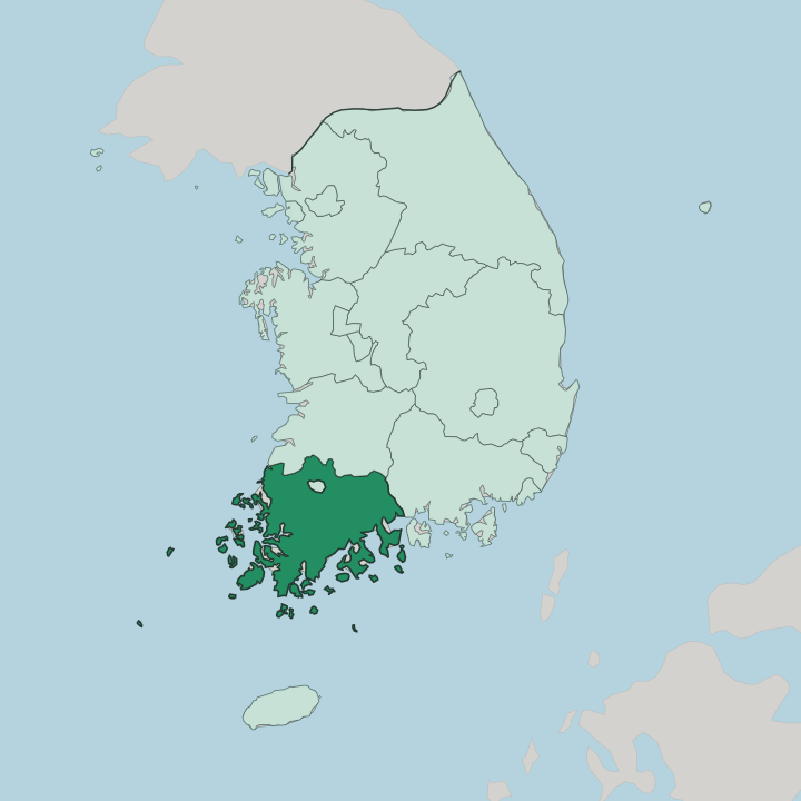
Towns & cities in Jeollanam-do
Pick a town or city — each links to where to stay.
Suncheon makes the easiest first base, the largest city in Jeollanam-do and the usual jumping-off point for the reed wetland on Suncheon Bay. Yeosu is the coastal alternative. It runs out along the water to Dolsan Island, crossed by a maritime cable car.
Mokpo anchors the far south-west, a port where the Yeongsan River empties into the Yellow Sea and ferries leave for the islands. For tea country, head inland to Boseong. Choose Suncheon for the wetland and gardens, Yeosu for the coast, Mokpo for the western port, or Boseong when you want to walk the green tea hills.
About Jeollanam-do
Food is the calling card.
What is Jeollanam-do known for?
Jeollanam-do fills the south-western corner of mainland South Korea, and cooks here practise what the country calls Namdo cuisine, a style Koreans cross the whole peninsula to eat. Suncheon is the largest city, edged by a reed wetland on Suncheon Bay. Yeosu strings itself out along the coast toward Dolsan Island, while Boseong wraps whole hillsides in rows of green tea.
Islands do the rest. The Yellow Sea laps the western shore and the Jeju Strait opens to the south.
Where is Jeollanam-do?
Jeollanam-do occupies the south-western corner of mainland South Korea, in the region Koreans call Honam. It is the southernmost province on the peninsula. North Jeolla lies over its northern border and South Gyeongsang to the east, while the sea takes every other side. The Yellow Sea washes the western shore, and the Jeju Strait opens to the south toward the island of Jeju.
That southern and western edge shatters into islands. Nearly 2,000 of them fringe the province, and roughly three-quarters lie uninhabited, drawing out a coastline that accounts for about a third of the country's entire shore. Inland the land is only partly mountainous.
Broad plains follow three rivers down to the coast, the Seomjin in the east, the Yeongsan in the west, and the Tamjin between them. Those river plains made the province Korea's granary, the flat rice country that fed much of the peninsula. The Yeongsan gathers the western lowlands and runs past Naju before reaching the sea at Mokpo.
The Seomjin traces the eastern boundary toward Gwangyang and its bay. Water is the constant. Between the rivers, the tidal flats, and the scattered islands, no corner of Jeollanam-do sits far from a shore or a stream.
What is Jeollanam-do like?
Ask a Korean where the best food is. Chances are the answer points to Jeollanam-do. The province anchors what the country calls Namdo cuisine, and its reputation as the peninsula's table rests on fertile plains, a warm coast, and long practice with ferment.
A single meal here can arrive as hanjeongsik, a spread of dozens of small dishes crowding the table at once, from grilled fish to mountain herbs to jars of pickles. Fermentation is the local art. Salted anchovies, soy pastes, and sharp kimchi have been made along this coast for generations, and the most notorious dish of all is hongeo, skate fermented until it stings, a delicacy tied to Yeongsanpo near Naju and eaten across Mokpo.
Beyond the table, the landscape shapes daily life. Boseong lays green tea across its hills in curving rows, drawing walkers who come to smell the leaf and watch the picking. On Suncheon Bay the reeds grow taller than a person, a coastal marsh registered as a protected wetland and one of the largest reed colonies in Korea.
Yeosu turns to the water, its cable car crossing the strait toward Dolsan Island. The Jeolla dialect marks the speech, warmer and looser than Seoul's, part of the strong regional identity of the Honam south-west.
What is the history of Jeollanam-do?
The name Jeolla is old. A single province called Jeolla-do was drawn up in 1018, under the Goryeo dynasty, taking its name from the leading towns of Jeonju and Naju. It held together for centuries.
In 1896 the government split that long province in two along its middle, and the southern half became Jeollanam-do while the northern half became North Jeolla. The line has stood ever since. Naju, once important enough to lend the province half its name, ranks among its smaller cities.
What is the climate of Jeollanam-do?
Jeollanam-do has a humid subtropical climate, the warmest and wettest corner of mainland Korea. Summers are hot and sticky. The East Asian monsoon dumps most of the year's rain between June and September, soaking the rice plains along the Yeongsan and Seomjin rivers just when they need it.
Winters turn cooler and drier, milder near the coast than up in the hills, and the Yellow Sea keeps the western shore from the hard cold felt further inland. Spring and autumn are the kindest seasons for walking the tea hills at Boseong.
How do you get to Jeollanam-do?
Most travellers reach Jeollanam-do overland from Seoul. Fast KTX trains run south to Suncheon, Yeosu, and Mokpo in a few hours, making the coast an easy long-weekend trip from the capital. Muan County holds a regional airport on the western side of the province.
Once you arrive, the towns sit far enough apart that a car or the intercity buses help. Ferries fan out from Mokpo and the southern ports to the province's many islands.
Good for
Updated July 2026