South Korea
Gyeonggi-do, South Korea — Towns & Travel Guide


Gyeonggi-do is the province wrapped around Seoul, holding more people than any other in South Korea and its ring of fortress towns.
About Gyeonggi-do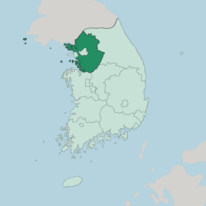
Towns & cities in Gyeonggi-do
Pick a town or city — each links to where to stay.
Most beds in Gyeonggi-do sit in the cities that ring Seoul, each one built around a different draw. Suwon is the obvious first base. Its centre is wrapped by the Hwaseong Fortress walls, floodlit at night and open to walkers all the way round, and fast trains reach the capital in half an hour.
Paju sits up on the Demilitarized Zone in the north, the launch point for border tours and the cafés and studios of Heyri Art Valley, while Yongin to the south pairs the open-air Korean Folk Village with the Everland theme park. Choose Suwon for the fortress and the easy commute; choose Paju or Yongin when a specific sight, the border or the folk village, is what pulls you out of the capital.
About Gyeonggi-do
What is Gyeonggi-do known for?
Gyeonggi-do encircles Seoul completely, and its very name marks that role: the two syllables mean the capital and the land around it. No province is more crowded. Its headline sight is Hwaseong Fortress, the stone-walled circuit that King Jeongjo threw around the centre of Suwon in the 1790s and that UNESCO later listed.
The north edge runs up against the Demilitarized Zone, the fortified strip dividing the two Koreas, and day-trippers come to Paju to look across it. Southward, the kilns of Icheon have turned out celadon and white porcelain for generations of Korean potters.
Where is Gyeonggi-do?
Gyeonggi-do fills the north-west of South Korea, a broad lowland that curls entirely around Seoul and reaches west to the sea. The capital sits at its heart. So does Incheon, once part of the province and now the seaport and airport gateway just west of it.
The Han River cuts the province roughly in two, running down out of the eastern mountains, past the edge of Seoul, and out through a wide tidal estuary into the Yellow Sea. That river built the place. Its plain and tributaries have grown rice, barley and wheat for as long as records survive, and the flat, well-watered ground is part of why the old kingdoms planted their capital here rather than in the harder country beyond.
To the north the land climbs to the Demilitarized Zone, the fortified line where South Korea stops and North Korea begins, running for miles across the top of the province. Gangwon rises to the east in a wall of higher hills. The Chungcheong provinces lie to the south across gentler farmland. West is all coast, a long and shallow shore scattered with islands on the Yellow Sea, where the tide goes out for hundreds of metres and leaves mudflats behind.
Nowhere in the province is far from Seoul, and everywhere the pull of the capital is felt.
What is Gyeonggi-do like?
Gyeonggi-do carries the weight of having been the court's back garden for five centuries. Kings shaped this ground. When the Joseon dynasty planted its capital at Hanyang, the modern Seoul, the surrounding province became the place royalty built, farmed and buried in, and the traces are everywhere.
King Jeongjo's Hwaseong Fortress at Suwon is the grandest of them, a walled town raised in the 1790s to honour his father, its brick and stone gates blending Korean fort-building with ideas the scholar-official Jeong Yak-yong drew from China and the West. Craft ran just as deep. The kilns around Icheon and the old Gwangju porcelain grounds supplied the palace with celadon and white ware, and Icheon still fires pottery and throws a ceramics festival that fills its lanes.
The province wears its recent history too. Paju sits on the Demilitarized Zone, where the wire and the watchtowers of a war that never formally ended stand a short drive from art villages and bookshops, and the open-air Korean Folk Village at Yongin rebuilds thatched farmhouses and yangban homes from across old Korea. The shared language here, as across the country, is Korean.
What is the history of Gyeonggi-do?
The province has been the capital's frame for six hundred years. The name Gyeonggi was fixed early in the Joseon dynasty, once the court settled at Hanyang and the surrounding country was organised to serve it. That role cut both ways.
Sitting on the road to the capital, the province was the ground foreign armies had to cross to reach the throne, and its hill forts saw hard fighting, none harder than the siege of Namhansanseong, where a Joseon king held out against a Manchu army in the bitter winter of 1636 before surrendering. In the 1790s King Jeongjo raised Hwaseong Fortress at Suwon, part memorial to his father and part attempt to build a new seat of power outside Seoul. The division of Korea after 1945 then drew the frontier straight across the top of the province.
What is the climate of Gyeonggi-do?
Gyeonggi-do runs through four sharp seasons. Gyeonggi-do's winters are severe. Dry Siberian air pushes down over the province from December, holding temperatures below freezing and dusting the Han River plain with snow, while summer swings the other way into heat and heavy humidity.
The wettest stretch is the East Asian monsoon of July, when days of rain swell the river and its tributaries. Spring and autumn are the reward for enduring the extremes, mild and clear, and autumn in particular turns the ridges of Namhansanseong and the walls of Hwaseong Fortress the colour of the leaves.
How do you get to Gyeonggi-do?
Almost everyone reaches Gyeonggi-do through Seoul, and often without noticing the crossing. The capital's transit spills out into it. Incheon, on the coast just west, holds the international airport that most arriving travellers land at, and the subway and commuter trains run straight out from central Seoul to Suwon, Yongin and the other satellite cities in under an hour.
Fast KTX services stop at Suwon on the way south. For the north of the province and the Demilitarized Zone, tour coaches and a commuter line push up toward Paju and the border, where civilian traffic finally stops.
Updated July 2026