Romania
Hunedoara, Romania — Towns & Travel Guide


Hunedoara is a mountain county of southwestern Transylvania, where the Mureș cuts west between Dacian ruins and the Retezat peaks.
About Hunedoara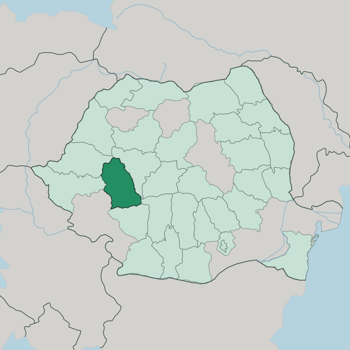
Towns & cities in Hunedoara
Pick a town or city — each links to where to stay.
Deva makes the natural base. It sits on the Mureș in the middle of the county, roads fanning out to every attraction, from the Dacian ruins in the hills to the castle towns and the mountains. The town of Hunedoara sits a short way south, its skyline owned by Corvin Castle.
Petroșani anchors the Jiu Valley coalfield far to the south, at the foot of the high Parâng. Chasing the Retezat lakes? Small Hațeg near the Râul Mare puts you closest to the trailheads. Pick Deva for a first visit and the ruins; choose Hațeg or Petroșani when the mountains themselves are the trip.
About Hunedoara
Castles and mountains.
What is Hunedoara known for?
Corvin Castle looms over the town of Hunedoara, a Gothic pile John Hunyadi began raising in 1446 and one of the largest such fortresses anywhere in Europe. Higher up sit older stones still: the Dacian fortresses of the Orăștie Mountains, with Sarmizegetusa Regia their ruined capital. The Retezat massif fills the south with glacial lakes and bare grey summits.
Deva, the county seat, watches over the Mureș valley from beneath its own citadel hill.
Where is Hunedoara?
Hunedoara spreads across the southwest of Transylvania, one of the mountain counties along Romania's inner arc of the Carpathians. Mountains hem it on almost every side. The Mureș River threads the whole county from east to west, carving the one broad corridor of low ground at around 200 metres and splitting the highlands into a northern half and a southern half.
To the south rise the Southern Carpathians in full force, the Retezat, Parâng and Șureanu ranges climbing toward Peleaga, the county high point at 2,509 metres. The Poiana Ruscă hills fill the west near the town of Hunedoara, and the Apuseni close off the north. Its rivers gather to the Mureș from these heights: the Strei, the Cerna and the Râul Mare drain the southern peaks and carve wide green valleys as they fall.
That southern wall holds the county's wildest ground. Retezat National Park, Romania's first, protects the glacial cirques where Bucura, the country's largest glacial lake, sits ringed by summits above the treeline. Roads and rail follow the Mureș and the Strei because the mountains leave little other room.
Deva stands near the middle of it all, on the north bank of the river beneath a lone volcanic crag. From there the county tips away into rock in every direction but west.
What is Hunedoara like?
Iron and stone run through the character of this county. For centuries the smiths of Hunedoara forged swords and spears traded across Europe, and the ore under the Poiana Ruscă hills built the largest steelworks in Romania around the old town. That industrial past sits oddly beside the deep antiquity above it.
The Dacians worked this same iron in the Iron Age, and their sanctuaries in the Orăștie Mountains still draw pilgrims of a sort up the forest tracks to Sarmizegetusa Regia. Romanian is the language of daily life here, in the towns of the Mureș and the villages of the high valleys alike. The Jiu Valley gives the county a second, harder identity.
Its coal towns, Petroșani chief among them, grew up around the mines in a closed mountain basin, a world of pithead wheels and workers' blocks with the Retezat rising white behind them. Older still are the stone churches scattered through the countryside, among them the small Densuș church built partly from Roman blocks carted down from the ruined imperial capital nearby. Folk festivals mark the seasons in the Hațeg country and the mountain hamlets.
Little of this is polished for visitors. The county wears its layers plainly, Dacian, Roman, medieval and industrial, one atop the next.
What is the history of Hunedoara?
Few Romanian counties carry a longer record. The Dacians made their capital here at Sarmizegetusa Regia, high in the Orăștie Mountains, before Rome broke the kingdom around 106 AD and turned the iron-rich land into a province of its own. The conquerors built their provincial capital nearby, Ulpia Traiana Sarmizegetusa.
Iron endured. Much later John Hunyadi raised Corvin Castle from 1446, funded by the ore wealth that made the town of Hunedoara. The county itself was drawn on the map in 1925, gathering these mountains under one administration in Greater Romania.
What is the climate of Hunedoara?
Across Hunedoara, height dictates the climate. Deva and the Mureș corridor enjoy the mildest climate in Transylvania, sheltered by the Apuseni and Poiana Ruscă hills, with a faint sub-Mediterranean warmth reaching up the river and frost kept light in winter. Climb south into the Retezat and the story flips hard.
The high peaks hold snow deep into the warm months and stay cold and wet year round, so the glacial lakes lie frozen long after the valley has greened. Summers are pleasant in the lowlands. The mountains keep their own rules.
How do you get to Hunedoara?
No airport serves the county directly. Most travellers fly into Sibiu to the east or Timișoara to the west, then drive in along the A1 motorway, which runs the length of the Mureș corridor between Bucharest and the Hungarian border and passes through Orăștie and Deva. The railway carries its share as well.
Simeria, just north of Deva, is the rail junction where main lines to Arad, Timișoara, Cluj-Napoca and Bucharest meet, and branch trains reach the town of Hunedoara and the Jiu Valley from there. Once you are in, the mountains dictate the roads.
Good for
Updated July 2026