Syria
As-Suwayda Governorate, Syria — Towns & Travel Guide


As-Suwayda is Syria's southernmost governorate, a volcanic highland of black basalt and Druze towns south-east of Damascus.
About As-Suwayda Governorate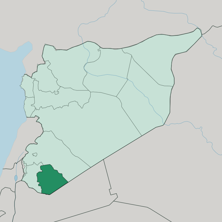
Towns & cities in As-Suwayda Governorate
Pick a town or city — each links to where to stay.
As-Suwayda city is the natural base. It sits on the western slope of Jabal al-Druze, where the road down from Damascus reaches the mountain, and it holds most of the governorate's beds and services. Shahba lies to the north-west, the Roman town of Philippopolis, worth the trip for its theatre and mosaics even if you sleep back in the capital.
Salkhad guards the eastern hills under its old citadel. Stay in As-Suwayda city for a first visit; the smaller towns are day trips out to the ruins and the basalt.
About As-Suwayda Governorate
What is As-Suwayda Governorate known for?
As-Suwayda is Syria's Druze heartland. Its towns carry stone built from black volcanic rock. The governorate covers most of Jabal al-Druze, the basalt massif that gives the whole region its dark colour and its name, and Druze villages ring the mountain's flanks.
Shahba preserves a full Roman grid, once the imperial town of Philippopolis, while Qanawat keeps Nabataean and Roman temples on the slopes above the capital at As-Suwayda. Grapes and apples grow in the volcanic soil.
Where is As-Suwayda Governorate?
As-Suwayda fills the far south-east of Syria, the country's southernmost governorate. It is a highland of black basalt. Almost the whole of Jabal al-Druze falls inside its borders, a volcanic massif of scattered cones that climbs to Tell Qeni, the high point of the range, above the surrounding plateau.
The land is young in geological terms, built by more than a hundred basaltic volcanoes that erupted across the plateau over the last few million years, and the dark lava has weathered into deep, fertile soil. Daraa Governorate borders it to the west, across the wider Hauran plain. Rif Dimashq Governorate wraps the north and north-east. To the south and south-east the border with Jordan runs out into the steppe. That eastern steppe is the Harrat al-Sham, a bleak sheet of old lava, and the tangled basalt of the Lajat spreads across the north-west corner.
Few rivers cross the mountain. Rain, not rivers, waters the fields here, caught by the high ground and soaked into the volcanic ground. The capital at As-Suwayda sits on the western flank, where the cultivated slopes meet the road up from the plain.
What is As-Suwayda Governorate like?
As-Suwayda is defined by the Druze. This is their heartland in Syria. The Druze faith, an offshoot of Islam that keeps its inner teaching to an initiated few, took root on this mountain when families moved here from Mount Lebanon in the late 17th and early 18th centuries, and the region soon took the name Jabal al-Druze in their honour.
Self-reliance runs through the local character, and the mountain has a long habit of resisting outside rule. Arabic is the everyday language. Villages of black basalt houses cover the slopes, many of them raised on Roman and Byzantine foundations, so the past is literally built into the walls.
Christians and a Sunni Bedouin minority live among the Druze majority, mostly around the capital and the eastern fringe. Grapes and apples define the farming year. Vineyards climb the volcanic slopes, and the harvest, the local feasts and the tight bonds of village and family shape the rhythm of the year far more than any city fashion does.
Wine and arak have been pressed from those grapes for generations. Hospitality to a guest is close to a rule of life, and a stranger who reaches a Druze village will rarely be let go without coffee and a place at the table.
What is the history of As-Suwayda Governorate?
People have worked this basalt since prehistory. The Nabataeans, the caravan traders who cut Petra from rock, built here first, and Qanawat still keeps their temples on the slope above the capital. Rome followed.
The emperor Philip the Arab, born in the region, refounded his home village as the planned city of Philippopolis in the year 244, and its grid, theatre and famous mosaics survive at Shahba. Druze settlers arrived far later, moving up from Mount Lebanon around the turn of the 18th century and giving Jabal al-Druze its modern name.
What is the climate of As-Suwayda Governorate?
As-Suwayda has a Mediterranean mountain climate, cold and wet in winter, dry and bright through the long summer. Height makes the difference. The volcanic uplands of Jabal al-Druze catch far more rain than the plains below, and the highest ground can see snow while the steppe to the east stays parched.
Winters are genuinely cold for Syria, summers warm rather than fierce, and almost all the rain falls between autumn and spring. That seasonal water, held in the basalt soil, is what feeds the vineyards.
How do you get to As-Suwayda Governorate?
As-Suwayda has no airport of its own. Almost everyone comes overland from Damascus, roughly 90 kilometres to the north-west, where the nearest international airport sits. One main road runs south from the capital across the Hauran plain and climbs the spine of the governorate, threading through Shahba before it reaches As-Suwayda city and carries on to Salkhad in the east.
Shared taxis and buses work that route. Inside the governorate, local roads fan out from the capital to the mountain villages and the ruins.
Good for
Updated July 2026