Thailand
Changwat Bueng Kan, Thailand — Towns & Travel Guide


Thailand's youngest province, Bueng Kan lines the Mekong in the far northeast, a land of rubber plantations, forested hills, and Naga folklore.
About Changwat Bueng Kan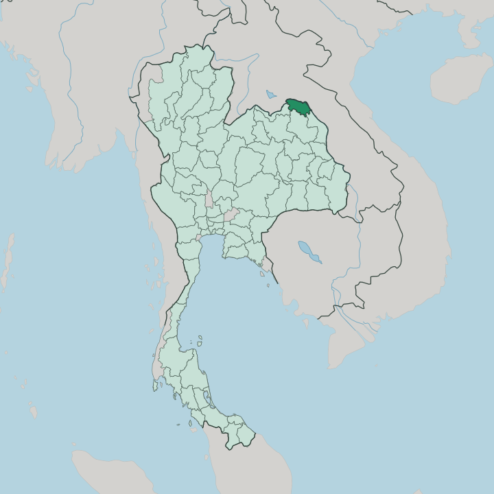


Towns & cities in Changwat Bueng Kan
Pick a town or city — each links to where to stay.
Most visitors base themselves in Bueng Kan town, the riverfront capital facing Pakxan across the Mekong. It is the road hub. From there the sights spread out.
South toward the Bueng Khong Long wetland lie Naka Cave and the ridges of Phu Langka National Park; the forested southeast around Phu Wua Wildlife Sanctuary hides waterfalls and wild elephants; and a short run from the capital itself, the Phu Sing tableland in Mueang Bueng Kan district lifts to the Three Whale Rock of Hin Sam Wan. Pick the town for a first stay, or a country guesthouse when the caves and forests are the point.
About Changwat Bueng Kan
What is Changwat Bueng Kan known for?
Bueng Kan is Thailand's newest province, carved from Nong Khai in 2011. It fronts the Mekong River, with Laos on the far bank. Rubber made its name.
Where the rest of the northeast grows rice, Bueng Kan turned to para rubber, and tapped plantations blanket much of the interior. Travellers come for the sandstone: the three humped boulders of Hin Sam Wan, the serpent-scaled walls of Naka Cave, and the cliff-top monastery of Wat Phu Tok, reached by wooden stairways bolted to the rock.
Where is Changwat Bueng Kan?
Bueng Kan sits in the far northeastern corner of Thailand, in the upper reaches of the region called Isan. The Mekong River draws its entire northern and eastern edge. Across that water lies Laos.
The Bolikhamsai province of Laos faces the provincial capital directly, its town of Pakxan looking back across the current. Inland, three Thai provinces wrap the rest of the border: Nong Khai to the west, Sakon Nakhon to the south, and Nakhon Phanom downstream to the southeast. Bangkok lies far away to the south-west, some 750 kilometres off by road. The land itself climbs away from the river.
Along the Mekong the ground is low floodplain, planted with rice and rubber. Behind it the country rises into forested sandstone hills and low plateaus, the tablelands of Phu Wua and Phu Langka, where waterfalls drop off the rock in the rains. Marshes gave the province its name.
Bueng means a freshwater marsh, and the broad Bueng Khong Long wetland in the south is the largest of many that pool across the plain. Forest survives mainly on the higher ground, in the sanctuaries and parks, while the lowlands have gone to plantation and paddy.
What is Changwat Bueng Kan like?
Life here is Isan life, closer in speech and kitchen to Laos than to Bangkok. Most people speak the Isan dialect of Lao at home and Thai at school and office. Sticky rice, grilled river fish, and fiery som tam anchor the table.
The province keeps the deep Buddhist grain of the northeast, and its forests hold some of Thailand's austere meditation monasteries. Wat Phu Tok is the emblem of that tradition: a sandstone tower ringed by seven levels of hand-built wooden walkways, climbed as a moving act of devotion. Monks of the forest lineage still keep to the caves and ridges above the rubber.
The Mekong shapes belief as much as trade. Along the river runs the cult of the Naga, the great water serpent, and Bueng Kan's Naka Cave takes its name from it, its scaled sandstone read by pilgrims as the coils of a petrified snake. At the end of Buddhist Lent, crowds still gather on the banks for the Naga fireballs, glowing orbs said to rise from the water.
Everyday life turns on rubber. Dawn brings the tapping, when families walk the plantation rows to score the bark and set the cups before the heat, and the smell of drying latex hangs over village yards. It is a working countryside, not a museum.
What is the history of Changwat Bueng Kan?
For most of the last century Bueng Kan was simply the eastern end of Nong Khai. The provincial capital lay a long day's travel away. By 1994 locals were already petitioning to govern their own riverside districts, but the 1997 financial crisis stalled the campaign for more than a decade.
Momentum returned after 2010. Parliament passed the Act Establishing Changwat Bueng Kan, King Bhumibol Adulyadej gave his assent, and in 2011 the new province took effect, eight districts cut from Nong Khai, Thailand's seventy-sixth and youngest.
What is the climate of Changwat Bueng Kan?
Bueng Kan runs on the monsoon. The wet season sweeps in from the southwest around May and holds until October, when the Mekong rises brown and fast and the waterfalls of Phu Wua are at full roar. Then the rains quit.
A cool, dry spell follows from November, with the coldest mornings over the river in December and January. Before the rains return, March to May turns hot and hazy, the fields waiting on the first storms. It is tropical throughout, tempered a little by the river and the forested high ground.
How do you get to Changwat Bueng Kan?
No airport serves Bueng Kan directly. Most travellers fly into the regional airports at Udon Thani, Sakon Nakhon, or Nakhon Phanom, then drive the last stretch to the river. From Bangkok it is an overnight haul, better slept through on a night bus or bridged by a short flight north.
Two roads carry the traffic: Highway 212 traces the Mekong up from Nong Khai and Nakhon Phanom, and Highway 222 climbs in from Sakon Nakhon, the pair meeting at Bueng Kan town. For Laos, the crossing is the Mekong itself, over to Bolikhamsai on the far bank.
Updated July 2026