Thailand
Changwat Nakhon Phanom, Thailand — Towns & Travel Guide


A province of northeastern Thailand strung along the Mekong, facing the limestone hills of Laos and anchored by the stupa of Phra That Phanom.
About Changwat Nakhon Phanom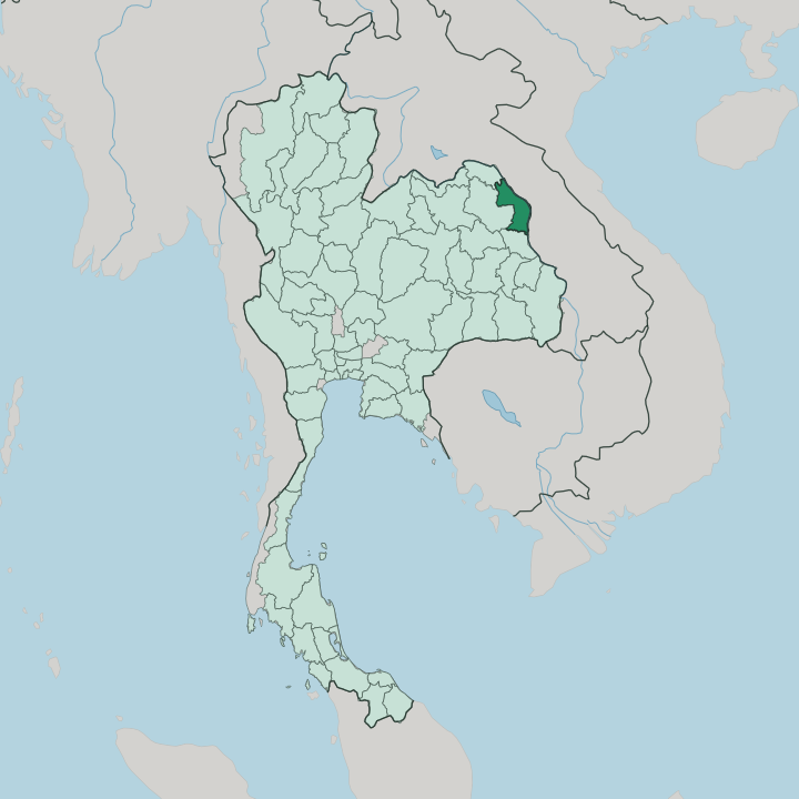


Towns & cities in Changwat Nakhon Phanom
Pick a town or city — each links to where to stay.
Most visitors base themselves in the city of Nakhon Phanom, where the riverside promenade, the night market and most hotels look across the Mekong to Thakhek. Head south for pilgrimage. That Phanom gathers around its golden stupa near the Mukdahan line, while Renu Nakhon draws weavers inland to its Phu Thai looms.
Up in the north, the wetland town of Si Songkhram sits inland on the lower Songkhram, ringed by fishing villages and flooded forest before the river reaches the Mekong downstream. Stay in the capital for river views and transport; choose the district towns when you want temples, textiles or quiet water.
About Changwat Nakhon Phanom
What is Changwat Nakhon Phanom known for?
Nakhon Phanom means 'city of mountains,' though the peaks it names rise across the Mekong in Laos. The province itself is river country. Its riverfront capital looks over the water to Thakhek, and a promenade of French-Lao shophouses lines the bank.
Above all, the province is known for Phra That Phanom, the tall gilded stupa that is the most revered Buddhist monument in the whole of Isan. Each October the Mekong fills with illuminated boats. Lao roots, Vietnamese quarters and Phu Thai villages give the towns a border-country character found nowhere else in Thailand.
Where is Changwat Nakhon Phanom?
Nakhon Phanom lies in the far north-east of Thailand, in the region called Isan. It is border country. The province stretches as a long ribbon down the west bank of the Mekong, which here forms the entire frontier between Thailand and Laos.
Directly across the water sits Thakhek, capital of the Lao province of Khammouane, its limestone hills rising where Nakhon Phanom has none. Bueng Kan lies upriver to the north. Sakon Nakhon borders it inland to the west, and Mukdahan continues the Mekong bank downstream to the south. Away from the river, the land is mostly flat. Most of the province is Mekong floodplain, planted with rice and broken only by low rises and pockets of forest in the north.
The Songkhram River drains that northern country, joined by the smaller Oun before it loops west to east and empties into the Mekong at Tha Uthen, below the wetland town of Si Songkhram. Only the Kum waters the flatter south. The name means city of mountains.
Yet the province holds barely a hill; the peaks that named it stand across the border in Laos, and the view of them from the Thai bank is what the old riverfront town was built to face. Bangkok lies far to the south-west, a long haul across the Khorat Plateau.
What is Changwat Nakhon Phanom like?
Life here is Lao as much as Thai. The everyday language is Isan, the local form of Lao, and the food follows it: sticky rice, grilled river fish, fiery som tam and the fermented flavours of the Mekong. Mor lam music and the khaen mouth-organ carry the sound of the region.
But the border has layered other peoples on top. Renu Nakhon is a Phu Thai town, famous for its dance and for looms that still weave cotton and silk in old patterns. A Vietnamese community has lived along this stretch of the Mekong for generations.
Ho Chi Minh himself sheltered at Ban Na Chok in 1928, outside the capital, and a memorial house there still marks the years he spent among the exiles. Faith centres on the river. Phra That Phanom is the holiest stupa in Isan, and its yearly festival draws pilgrims from both banks of the Mekong, Lao and Thai alike.
At the close of the Buddhist Lent the water itself becomes the stage. Villages float the Lai Reua Fai, great illuminated boats rigged with lamps, down the Mekong after dark. The riverfront capital keeps rows of French-Lao shophouses from the colonial trade era.
Weaving runs deep. Indigo cloth and patterned silk from the Phu Thai and Lao villages fill the markets, sold beside the fish and the sticky rice that anchor every meal.
What is the history of Changwat Nakhon Phanom?
For centuries the land belonged to the Lao world, part of the Lan Xang kingdom whose princes held both banks of the Mekong long before any modern border was drawn. It began on the Lao bank. Settlers moved it across to the Thai side in 1766, and King Rama I later renamed it the city of mountains.
Older than any of this is the stupa. Phra That Phanom is said to date to the years just after the Buddha's death, and after a Lao-style rebuilding it stood until heavy monsoon rain toppled it in 1975, when the province raised the tower once more.
What is the climate of Changwat Nakhon Phanom?
The climate is tropical and monsoon-driven, split into three seasons. Rains dominate. From May the south-west monsoon soaks the province, and this upper stretch of the Mekong is among the wettest parts of Isan, its downpours swelling the river and flooding the Songkhram wetlands.
A cool, dry spell follows from November, with clear mornings that can turn genuinely cold along the water. March and April bring the heat before the rains return.
How do you get to Changwat Nakhon Phanom?
For most, the plane is the way in, since daily Bangkok flights land at Nakhon Phanom Airport just west of the capital and spare a long overland haul across the plateau. Nakhon Phanom Airport, just west of the capital, takes daily flights from Bangkok that cut a long overland journey to about an hour. By road it is a haul north-east from Bangkok across the Khorat Plateau, served by long-distance buses.
No railway reaches the province. The bus and the plane do the work. For onward travel the Third Thai-Lao Friendship Bridge carries the road over the Mekong to Thakhek, opening the route into Laos and beyond to Vietnam.
Good for
Updated July 2026