Thailand
Changwat Lampang, Thailand — Towns & Travel Guide


Changwat Lampang is a northern Thai province in the Wang River valley, known for Burmese-style temples and Thailand's last working horse carriages.
About Changwat Lampang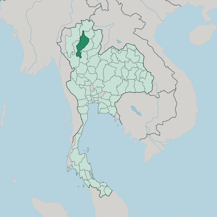


Towns & cities in Changwat Lampang
Pick a town or city — each links to where to stay.
Most visitors base themselves in Lampang town, on the south bank of the Wang River, within walking reach of the Kad Kong Ta old market street. Lampang keeps its sights close together. Pilgrims often head instead to Ko Kha, the district south-west of the city where Wat Phra That Lampang Luang crowns its walled hill.
For mountains and mineral springs, Chae Son sits up in the Phi Pan Nam foothills, while Hang Chat, on the highway toward Chiang Mai, sits beside the National Elephant Institute and its teak-hauling herd. Choose the town first; save the hills for when you tire of temples.
About Changwat Lampang
Two things set the province apart.
What is Changwat Lampang known for?
Lampang town is the last place in Thailand where horse-drawn carriages still work the streets, a habit that arrived with the railway in 1916. Its temples are the other draw. Nine of the country's surviving Burmese-style temples stand here, built with money made from teak logging in the late nineteenth century, and the hilltop Wat Phra That Lampang Luang south-west of the city ranks among the most revered Lanna sanctuaries in the north.
Teak also gave the province its elephants, and the National Elephant Institute still keeps a working herd.
Where is Changwat Lampang?
Changwat Lampang lies in upper northern Thailand, in the broad valley of the Wang River. The Wang feeds the Ping River, itself a tributary of the Chao Phraya, and it drains the province southward through Lampang town before joining the larger river system on the central plains. Two mountain ranges wall the valley.
The Khun Tan Range rises along the western side toward the border with Lamphun and Chiang Mai, and the Phi Pan Nam Range climbs away to the east and north. Doi Luang, one of the high peaks of the Phi Pan Nam, stands over the northern districts. Forest covers most of the province.
Seven provinces ring it. Chiang Mai and Chiang Rai lie to the north-west and north, Phayao and Phrae to the east, Lamphun to the west, and Tak and Sukhothai to the south. Much of that upland is protected.
Doi Khun Tan National Park straddles the western range on the old rail line to Chiang Mai, and Chae Son National Park guards hot springs and waterfalls in the Phi Pan Nam foothills to the north. East of the capital, the Mae Mo basin holds the lignite beds that feed the largest coal-fired power station in the country. Beyond the parks, teak forest and rice valleys fill the land between the ridges.
What is Changwat Lampang like?
Lampang keeps a northern, Lanna character, and it wears its past more quietly than Chiang Mai. Teak built the modern city. Logging firms and their Burmese craftsmen raised ornate wooden temples across town in the late nineteenth century, and monasteries like Wat Si Rong Mueang and Wat Pa Fang still carry the tiered Burmese roofs and mirror-glass work of that era.
The white rooster is the local emblem, drawn from the founding legend of Wat Phra That Lampang Luang, and it turns up on everything from the city seal to the province's famous pottery. Clay is the other craft. Kilns around the city turn out the hand-painted chicken bowls that Thais associate with Lampang, made from local kaolin.
Daily life stays slow. Horse carriages still carry passengers and wedding parties through the old quarter, the Saturday and Sunday walking market fills the teak-shophouse lane of Kad Kong Ta, and the herd at the National Elephant Institute keeps the region's logging past alive in a gentler form. People here speak Thai, usually in the Kham Mueang northern dialect.
That unhurried mood is why some Thais call the province a last refuge.
What is the history of Changwat Lampang?
The town began as Khelang Nakhon in the Hariphunchai era, the Mon kingdom that held the north from the 7th century. King Mangrai folded Hariphunchai into his Lanna kingdom in 1292. Burmese armies later ruled the north for two centuries, until a local lord, Kawila, drove them out with Siamese help in the late 18th century and rebuilt Lampang.
Siam made it a formal province in 1892. Teak and rail did the rest.
What is the climate of Changwat Lampang?
Lampang runs on three seasons. The cool months from November to February are the pick, with dry, sunny days and mist settling in the Wang River valley at dawn. Cold air slipping down from the north can drop valley nights close to freezing.
Then comes the heat. March and April turn hot and hazy as farmers burn the stubble, before the south-west monsoon breaks in May and brings rain through to October. The mountains that wall the valley trap the warmth, so the lowlands around Lampang town sit hotter than the surrounding hills.
How do you get to Changwat Lampang?
The old northern railway is the classic way in. Trains from Bangkok to Chiang Mai stop at the wooden Nakhon Lampang station, climbing over the Khun Tan Range through the longest rail tunnel in the country. Roads are quicker.
Highway routes run up from Bangkok and over from Chiang Mai, which sits about an hour and a half to the north-west by car. Lampang Airport handles a few short hops from the capital. Many travellers simply add the province to a Chiang Mai trip and drive across.
Good for
Updated July 2026