Thailand
Changwat Chiang Rai, Thailand — Towns & Travel Guide


Changwat Chiang Rai is Thailand's northernmost province, a mountain frontier on the Mekong at the Golden Triangle borders of Laos and Myanmar.
About Changwat Chiang Rai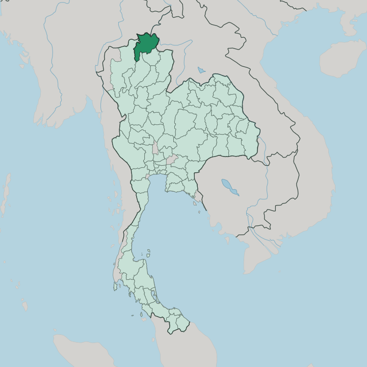


Towns & cities in Changwat Chiang Rai
Pick a town or city — each links to where to stay.
Chiang Rai city is the natural first base, set in the Kok River valley with the night bazaar and the province's widest choice of rooms. Everything else lies uphill. North toward the Mekong, Chiang Saen and Sop Ruak sit on the Golden Triangle border within sight of Laos.
West and up, the tea terraces of Doi Mae Salong and the ridge gardens of Doi Tung trade heat for mist and cool nights. Pick the city for services; pick the mountains for quiet.
About Changwat Chiang Rai
Two things pull visitors north.
What is Changwat Chiang Rai known for?
The first is Wat Rong Khun, the all-white contemporary temple that has made the province famous far beyond Thailand. The second is the Golden Triangle, the storied river junction on the Mekong that joins Thai, Lao, and Burmese land at Sop Ruak. Between them lies a province of tea-covered ridges, Akha and Lahu hill villages, and the old Lanna capital of Chiang Rai city, founded by King Mangrai.
Mountains define almost everything here.
Where is Changwat Chiang Rai?
Changwat Chiang Rai sits at the very top of Thailand. It is the country's northernmost province, wrapped along two international borders: Myanmar's Shan State to the north and west, and the Lao province of Bokeo to the east across the Mekong. Within Thailand it adjoins Chiang Mai province to the west and Phayao to the south.
Mountains cover most of it. Ranges run roughly north to south, folding the province into a series of river valleys and upland plateaus, with the provincial capital spread across the broad basin of the Kok River. Water shapes the north.
The Mekong forms the eastern boundary with Laos, while the Ruak River and the little Mae Sai river trace the Burmese line, and the three borders converge at the Golden Triangle near Sop Ruak. Southward, the Kok River flows down from Myanmar through the capital before joining the Mekong. The highest ground rises in the west and along the border, where Doi Mae Salong and Doi Tung climb well above the valley floor into cool, tea-growing country.
Average elevation across the province runs near 580 metres. A border town, a river town, a tea mountain, the north strings them together along the water.
What is Changwat Chiang Rai like?
This is Lanna country. For centuries the north belonged to the Lanna kingdom rather than to Bangkok, and that inheritance still colours daily life, the Kham Mueang dialect, the whitewashed temple eaves, and the slower northern manner. The old faith runs deep.
Wat Phra Kaew in the capital once held the Emerald Buddha that later moved to Bangkok, and gilded Lanna monasteries stand in nearly every town. Yet the province is also unusually modern in its art. Chalermchai Kositpipat's white Wat Rong Khun, the sapphire Blue Temple, and Thawan Duchanee's brooding Baan Dam, the Black House, have turned local Buddhist imagination into destinations in their own right.
The other half of the story is upland and ethnic. Hill peoples, Akha, Lahu, Lisu, Mien, and Hmong among them, farm the ridges, each with its own dress, language, and New Year rites. Around Doi Mae Salong the culture turns Yunnanese: the village was settled by Nationalist Chinese soldiers who retreated across the border and planted the oolong terraces that still define the slope.
Tea is a way of life here. Down in the capital, a night bazaar fills with Lanna crafts, khao soi noodle stalls, and northern music after dark. Difference is the constant.
What is the history of Changwat Chiang Rai?
Chiang Rai is the birthplace of Lanna. In 1262 King Mangrai founded the city on the Kok River as the first capital of his new northern kingdom, naming it after himself. He looked south instead.
In 1296 he moved the capital to Chiang Mai, which overshadowed Chiang Rai for centuries afterward, and the older city faded to a provincial town. Centuries of Burmese and then Siamese rule followed. The modern province took shape under Bangkok in the early twentieth century, yet the north still counts its history from Mangrai.
What is the climate of Changwat Chiang Rai?
The north has three seasons, not four. A cool, dry spell from about November to February brings crisp mornings and mist pooling in the Kok River valley, the season travellers prize. Heat builds through March to May, when farmers clear fields and haze can settle over the basins.
Then the southwest monsoon arrives, greening the ridges from June into October. Altitude tempers all of it: Doi Mae Salong and Doi Tung stay noticeably cooler than the valley floor, cold enough for tea and for blankets at night. Bring a jacket for the hills.
How do you get to Changwat Chiang Rai?
Most visitors fly into Mae Fah Luang airport, just outside the capital, on the short hop up from Bangkok. Overland, the main road climbs from Chiang Mai in roughly three hours through the hills. This is border country.
At Mae Sai the road crosses into Myanmar, and at Chiang Khong a bridge carries it over the Mekong into Laos on the way toward Luang Prabang. Trains do not reach this far; the northern railway ends down at Chiang Mai. The last leg is by road.
Good for
Updated July 2026