Thailand
Changwat Phayao, Thailand — Towns & Travel Guide


Changwat Phayao is a quiet lakeside province of upper northern Thailand, wrapped around Kwan Phayao, the largest freshwater lake in the north.
About Changwat Phayao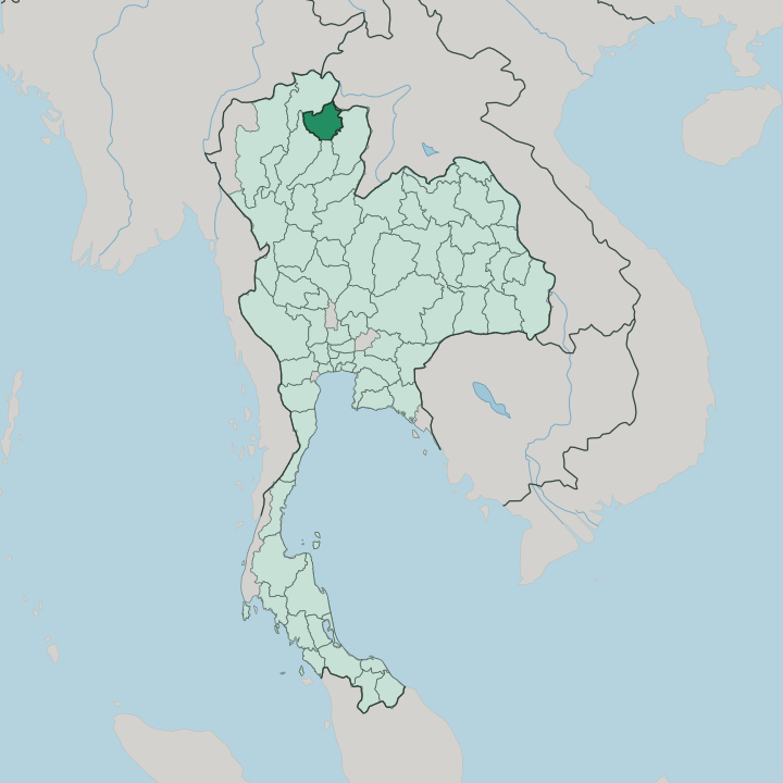


Towns & cities in Changwat Phayao
Pick a town or city — each links to where to stay.
Most visitors sleep in Phayao itself, the small provincial town set on the eastern shore of the lake. A handful of guesthouses and hotels line the water, an easy stroll from the promenade to the temple gate. Begin in Phayao town itself, where a handful of lakeside guesthouses stand an easy stroll from the promenade to the temple gate.
Chiang Kham, out to the north-east, suits travellers drawn to Tai Lü villages and the teak temples of the border country. The forest districts of Pong and Dok Khamtai run far quieter, closer to the reservoirs, waterfalls, and forest trails that climb into Doi Phu Nang National Park. Book ahead in the cool months.
Thai visitors then come north for the mist over Kwan Phayao.
About Changwat Phayao
The province is defined by water.
What is Changwat Phayao known for?
Kwan Phayao spreads in a broad half-moon below the city, and fishermen still work its shallow reach at dawn while the Phi Pan Nam mountains close off the western sky. On the shore stands Wat Si Khom Kham, whose seated Buddha, Phra Chao Ton Luang, is among the largest in the north. Lanna temples and Tai Lü weaving villages fill the valleys around Chiang Kham.
Forest covers roughly half the land. Doi Luang National Park and Phu Sang National Park protect the ridges of the Phi Pan Nam.
Where is Changwat Phayao?
Changwat Phayao lies in the far north of Thailand, inland from the Mekong and hard against the hills of the Laos border. Phayao touches no coast at all, set deep inland in the far north against the Lao border. Chiang Rai wraps around its north and west, Nan lies east across the mountains, and Phrae and Lampang close off the south, while the Lao province of Sainyabuli meets it along the north-eastern ridges. The Phi Pan Nam Range runs the length of the province from north to south, throwing up parallel ranges of forested hills that box in the valleys between them.
At the province's heart sits Kwan Phayao, a broad, shallow lake shaped like a half-moon. The Ing River feeds it, gathering the runoff of the surrounding hills before flowing on north toward the Mekong. Three forested peaks stand over the water, with Doi Luang the highest of them.
The town of Phayao sits on the eastern shore, in the valley the Ing cut. Forest covers close to half the province. Away from the lake basin, the land is a country of narrow river valleys, terraced paddy, and long wooded ridges reaching toward Laos and the Nan border.
What is Changwat Phayao like?
Life here runs at the pace of the lake. This is Lanna country, the old northern culture that once stood apart from Bangkok, and its mark shows in the curved temple roofs, the Kham Mueang speech of the markets, and the slow ritual of the morning alms round. Buddhism shapes the calendar.
Wat Si Khom Kham draws pilgrims to its great seated Buddha on the lakeshore, while Wat Analayo climbs a wooded hill west of the water with its garden of shrines. The province also holds one of Thailand's larger Tai Lü communities, settled around Chiang Kham after migrating south from Sipsongpanna generations ago. They keep their own weaving, temple styles, and dialect.
Food leans on the freshwater catch, with fish from Kwan Phayao, river weed from the Ing, and the herbs of the hills. The night market by the lake fills with grilled fish and northern curries after dusk. Phayao carries its history quietly.
It was the seat of an independent kingdom under Ngam Mueang, a thirteenth-century ally of the Lanna and Sukhothai rulers, and that memory still colours local pride.
What is the history of Changwat Phayao?
Phayao began as a kingdom of its own. Founded in the eleventh century, it grew powerful under Ngam Mueang before Lan Na absorbed it in 1338, after which Burmese wars left the old town abandoned for generations. Rama III refounded the settlement in 1843 as a frontier post against Burma.
It was folded into Chiang Rai in 1897. Phayao finally became a separate province of Thailand in 1977, the seventy-second to be carved out.
What is the climate of Changwat Phayao?
Phayao keeps three seasons. Cool, dry air settles over the north from about November, and morning mist hangs over Kwan Phayao until the sun burns it off, the season that draws Thai travellers up from the plains. The hot months of March and April bring haze and heat to the valleys.
Then the south-west monsoon breaks in around May, greening the Phi Pan Nam ridges and filling the Ing until the rains ease near October. The hills stay cooler than the Bangkok plain through the year.
How do you get to Changwat Phayao?
Phayao has no airport and no railway of its own. Most travellers fly into Chiang Rai, then drive south on Highway 1 for an hour or so through the hills. Buses run the same road.
Long-distance coaches climb up from Bangkok overnight and down from Chiang Mai and Chiang Rai by day, all threading the Phi Pan Nam passes into the Ing valley. From the town, local roads fan out to Chiang Kham and the national parks.
Good for
Updated July 2026