Thailand
Changwat Nakhon Pathom, Thailand — Towns & Travel Guide


Nakhon Pathom is a central-Thai province just west of Bangkok, built around Phra Pathommachedi, the tallest Buddhist chedi in the country.
About Changwat Nakhon Pathom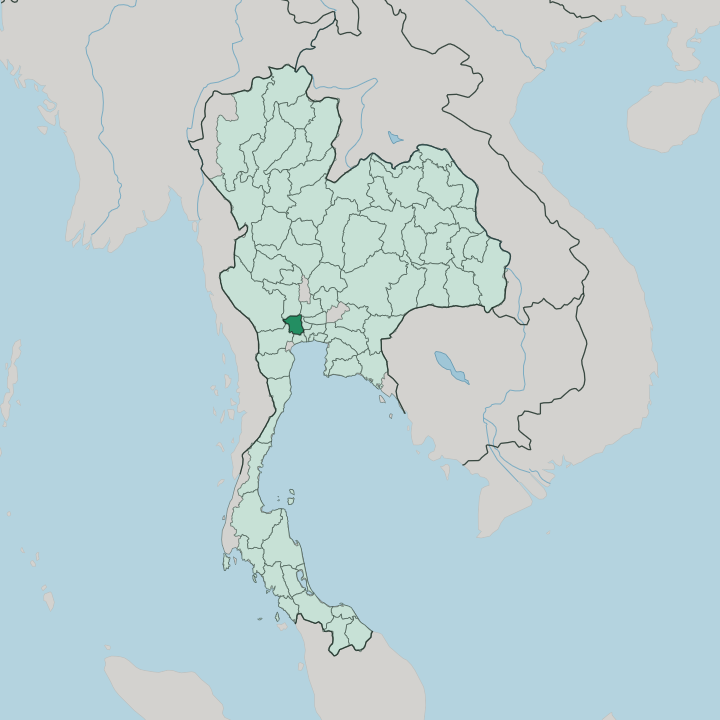


Towns & cities in Changwat Nakhon Pathom
Pick a town or city — each links to where to stay.
Most travellers sleep in Bangkok and come for the day, but the province rewards a night. Nakhon Pathom city puts you beside Phra Pathommachedi and Sanam Chandra Palace, close to the station and the evening food stalls. For a slower stay, Sam Phran strings resorts along the Tha Chin River near Suan Sampran and the Don Wai floating market.
Salaya, out toward Bangkok around Mahidol University and the Phutthamonthon park, suits campus visitors more than sightseers. Choose the capital first.
About Changwat Nakhon Pathom
What is Changwat Nakhon Pathom known for?
The province's fame rests on one monument. Phra Pathommachedi rises 127 metres above the provincial capital, the tallest Buddhist stupa in the country and the reason many Thais treat this ground as the place Buddhism first reached the kingdom. Long before that spire, the same site was the heart of Dvaravati, the Mon Buddhist culture that ruled the central plain more than a thousand years ago.
King Vajiravudh later raised Sanam Chandra Palace nearby. Orchards of pomelo and rice fields fill the flat land around, all of it an easy day trip west of Bangkok.
Where is Changwat Nakhon Pathom?
The province lies on the lower Chao Phraya plain, a short drive west of Bangkok. Flat land runs to every horizon. Almost the whole province is alluvial floodplain without a single mountain, a table of rice paddy, orchard, and canal broken only by low ground rising toward Kamphaeng Saen in the west.
The Tha Chin River, which locals call the Nakhon Chai Si, threads down through the middle of it, a distributary of the Chao Phraya that once carried trade between the two. Rich clay and year-round irrigation turned that flat ground into some of the most intensively farmed land in the country. This was coast once.
Centuries of silt from the Chao Phraya pushed the shoreline of the Gulf of Thailand steadily seaward, and the old harbour that made Nakhon Pathom rich was left stranded far inland. Seven districts fill the province, from Mueang Nakhon Pathom around the great chedi to Nakhon Chai Si, Sam Phran, and Phutthamonthon closer to the capital. Suphan Buri and Kanchanaburi lie to the north and west, Ratchaburi to the south, and greater Bangkok presses against the eastern edge through Nonthaburi and Samut Sakhon. Water still rules the land.
What is Changwat Nakhon Pathom like?
Faith organises daily life here. Phra Pathommachedi is not a museum piece but a working shrine, circled by monks and pilgrims, and every year around the November full moon its temple fair fills the town with stalls, lights, and likay theatre. The province keeps the memory of the Mon who built Dvaravati, whose stucco Buddhas and carved wheels of the law now sit in the national museum beside the chedi.
Pilgrims come from Bangkok and beyond to bow before it. Old devotion still shapes the calendar. There is a strong artistic streak too.
Silpakorn University, Thailand's foremost school of fine art, keeps a campus inside the grounds of Sanam Chandra Palace, and Mahidol University's Salaya campus draws students from across the country. The place has trained generations of Thai painters and sculptors. Food matters as much as art.
Cooks here are known for khao lam, sticky rice and coconut roasted inside bamboo tubes, and the riverside stalls of the Don Wai market on the Tha Chin sell smoked fish, sweets, and the sweet pomelo the province is proud of. Markets double as meeting halls.
What is the history of Changwat Nakhon Pathom?
The name means first city, and the claim is old. Nakhon Pathom grew into the largest walled centre of Dvaravati, the Mon Buddhist realm that dominated the central plain from the sixth to the eleventh century, and tradition holds that Buddhism first entered the land here. When the river shifted course the old city was abandoned, its people drifting downstream to Nakhon Chai Si for centuries.
King Mongkut revived the site in the mid-nineteenth century, ordering the ruined stupa encased in the towering chedi his son completed in 1870. Vajiravudh added Sanam Chandra Palace soon after.
What is the climate of Changwat Nakhon Pathom?
The province runs hot and humid all year, in the tropical-savanna band of central Thailand. Three seasons order the calendar. A dry, warmer stretch from November into February is the kindest time to climb the chedi steps, before the March-to-May heat pushes past forty on the worst afternoons.
Then the south-west monsoon breaks. From May into October it drives the rains that flood the paddies and swell the Tha Chin, the wettest and greenest half of the year. Nights rarely turn cold.
How do you get to Changwat Nakhon Pathom?
There is no airport here. Travellers fly into Bangkok and cover the last stretch by road or rail, an hour or so west of the capital when traffic allows. Trains on the Southern Line from Bangkok stop right beside Phra Pathommachedi, which makes the railway the easiest way in for anyone without a car.
Phetkasem Road and the expressways carry the buses and vans that leave the capital through the day. Once inside, songthaews and local buses link the market towns along the Tha Chin.
Updated July 2026