Thailand
Changwat Ratchaburi, Thailand — Towns & Travel Guide


Ratchaburi is a province of western Thailand, its Mae Klong plain rising west into the Tenasserim Hills on the Myanmar border.
About Changwat Ratchaburi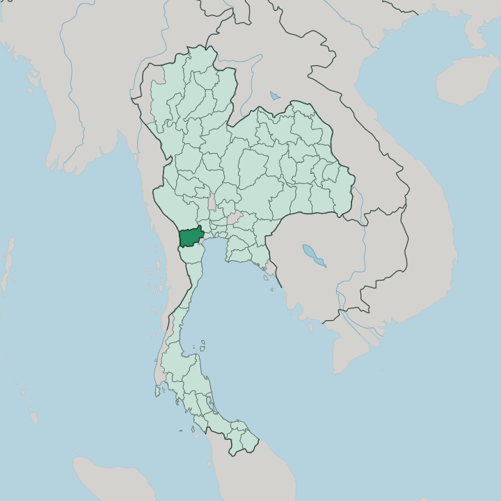


Towns & cities in Changwat Ratchaburi
Pick a town or city — each links to where to stay.
Ratchaburi rewards a short stay. The provincial town on the Mae Klong is the natural base, close to its kilns and the Damnoen Saduak canals a little to the east. For mountains rather than markets, Suan Phueng spreads ranches and hot springs along the Tenasserim edge near Myanmar, filling up with Bangkok families on weekends and thinning midweek.
Many visitors skip a hotel altogether and come out from Bangkok for the morning boats, then return. Pick the town for the river, Suan Phueng for the hills.
About Changwat Ratchaburi
What is Changwat Ratchaburi known for?
Two images carry the province's name. The Damnoen Saduak floating market draws boats heavy with fruit and noodles along its khlongs, and the ochre dragon jars fired in Ratchaburi's kilns sit in gardens across Thailand. Beyond the postcards, the Mae Klong threads the eastern rice plain while the Tenasserim Hills wall off the west, their limestone riddled with caves and bat colonies.
Suan Phueng has turned that upland edge into a weekend retreat of ranches and hot springs near the Myanmar frontier.
Where is Changwat Ratchaburi?
Ratchaburi fills a slice of western Thailand between the Gulf lowlands and the Myanmar border. It tilts. The land lies flat and wet in the east, where the Mae Klong braids into a web of khlongs that irrigate rice and orchards, then climbs steadily westward into the limestone ridges of the Tenasserim Hills.
Those hills run north to south as a natural wall, dividing Thailand from Myanmar beyond. Caves honeycomb the limestone, and while Khao Bin opens into lit chambers of stalactites, it is the roost at Khao Chong Phran that sends millions of bats streaming out at dusk. Roughly a third of the province stays under forest, most of it on these western slopes.
Its neighbours ring it on every side but the west. Kanchanaburi lies to the north, source of the Mae Klong, which forms there from two rivers joining at the provincial capital. Nakhon Pathom sits to the east on the road toward Bangkok, and Samut Songkhram lies to the southeast, carrying the Mae Klong's last miles down to the Gulf of Thailand. Phetchaburi closes off the south. Ratchaburi itself never reaches the coast, an inland province looking seaward down its own river.
What is Changwat Ratchaburi like?
The province is a patchwork of peoples. Mon families, descendants of settlers who crossed from Myanmar generations ago, still keep their own temples and dialect around Ban Pong and Photharam. Karen villages hold the forested slopes toward the border, and communities of Thai Song Dam, the Black Tai brought south in the wars of the old kingdoms, farm the plain alongside Thai-Chinese traders.
Nearly everyone is Buddhist. The wat at the centre of each town anchors its calendar of merit-making and festivals. Ratchaburi's signature is fired in clay.
Its potteries turn out the great brown water jars embossed with a coiling dragon, ong mangkorn, sold from yards along the highway and shipped nationwide for storing rice and rainwater. The other daily theatre is the water itself. At Damnoen Saduak, vendors paddle flat sampans loaded with mango and coconut through canals dug in the reign of Rama IV, a working market that became the country's picture of old Siam.
Older still are the brick foundations at Khu Bua, a Dvaravati town of the Mon that traded here more than a thousand years ago.
What is the history of Changwat Ratchaburi?
The name means the king's town. Kings shaped its story. Long before them, Mon settlers of the Dvaravati culture raised Khu Bua on the plain, and Khmer power later reached it from the east.
Under Ayutthaya the town guarded the western approach, the road by which Burmese armies marched on the capital through the hills. King Rama II rebuilt its walls on the left bank of the Mae Klong in 1817, and the province took its modern shape under the later reforms of King Rama V.
What is the climate of Changwat Ratchaburi?
Three seasons order the year. The hot months from March to May bake the Mae Klong plain, April fiercest of all, before the southwest monsoon sweeps in from the Gulf and turns June to October wet and green. September is the soaking heart of the rains.
Then the cool, dry season from November to February brings clear skies and mild nights, the easiest stretch for travel. The Tenasserim Hills to the west wring much of the rain from the incoming air, leaving their far slopes noticeably drier than the plain.
How do you get to Changwat Ratchaburi?
Bangkok is the way in. The capital lies about eighty kilometres to the east, and most travellers arrive at its airports and then come west by road or rail. The southern railway from Bangkok toward the Malaysian border runs straight through the province, stopping at Ban Pong and at Ratchaburi's own station beside the Mae Klong.
Highway 4, the old Phetkasem road, carries the buses and minivans that ferry day-trippers out to the Damnoen Saduak floating market. There is no airport of its own.
Good for
Updated July 2026