Thailand
Changwat Narathiwat, Thailand — Towns & Travel Guide


Narathiwat is the far southeast of Thailand, a Malay-Muslim coast on the Gulf of Thailand at the border with Malaysia.
About Changwat Narathiwat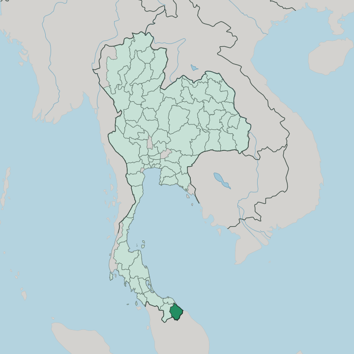


Towns & cities in Changwat Narathiwat
Pick a town or city — each links to where to stay.
Narathiwat town is the natural first base. The provincial capital sits where the Bang Nara empties into the Gulf, with Narathat Beach on one side and the golden Buddha of Khao Kong above. Su-ngai Kolok is the border.
Its market streets and rail terminus face Rantau Panjang across the Golok, the busiest crossing into Malaysia. Tak Bai holds the coast and the old temple of Wat Chonthara Sing-he, while Waeng climbs south into the Hala-Bala forest. Pick the capital for the sea, the frontier towns for the crossing.
About Changwat Narathiwat
What is Changwat Narathiwat known for?
This is Thailand's Malay south. More people here speak Patani Malay than Thai, pray at the mosque rather than the temple, and look across the Golok River to kin in Kelantan. Fishermen still paint their Kolae boats with flowers and flame-scroll patterns along the Gulf shore.
Inland, the rainforest of Hala-Bala shelters hornbills by the flock, and orchards ripen the sweet longkong the province claims as its own. Su-ngai Kolok marks the end of the line, Thailand's last railway station before Malaysia.
Where is Changwat Narathiwat?
Narathiwat lies at the bottom of Thailand, on the Gulf side of the Malay Peninsula. The Gulf of Thailand runs along its northern and eastern shore. Three borders close the rest. Yala sits to the west, Pattani to the north, and the Malaysian state of Kelantan across the south.
Much of that southern line follows the Golok River, which rises in the Sankalakhiri hills along the frontier and winds northeast through Waeng and Su-ngai Kolok before reaching the sea at Tak Bai. Jungle and low mountains cover most of the interior. The Bang Nara River drains the coastal plain.
It slips past the provincial capital and empties into the Gulf beside Narathat Beach, the long strand at the town's edge. South of town the shore curves into Ao Manao, a quiet bay below the wooded Khao Tanyong hill. Behind the coast the Budo range rises into Budo-Su-ngai Padi National Park, where the Pacho waterfall drops through the forest.
Further south the land climbs again. The rainforest of Hala-Bala spreads across Waeng and Sukhirin, one of the wildest tracts left in the country. Su-ngai Kolok sits inland on the river, the busy crossing point into Malaysia.
What is Changwat Narathiwat like?
This is the most Malay of Thailand's provinces. Most people here are Muslim, and the call to prayer, not the temple bell, sets the rhythm of the day. The everyday language is Patani Malay, close to the Kelantanese spoken over the border, and older texts still carry the Arabic-based Jawi script.
Families on both sides of the Golok are often kin. Mosques anchor the towns, from the modern Central Mosque at Narathiwat to the wooden Telok Manoh, a prayer house blending Thai, Malay, and Chinese styles counted among the oldest in the country. Fishing shapes the coast.
Along the Gulf, boat-builders still paint the Kolae, high-prowed craft covered in flowers and flame-scroll motifs rather than the human figures Islam forbids. Batik cloth, silat sparring, and the drumming choruses of dikir barat carry the same Malay current. The kitchens lean Malay, heavy with coconut, turmeric, and dried fish.
Orchards inland ripen the sweet longkong the province counts as its own. A Buddhist minority lives here too. Their gilded Buddha looks out from Khao Kong above Narathiwat, and the old temple at Tak Bai keeps a story the whole border remembers.
What is the history of Changwat Narathiwat?
For centuries this coast answered to Patani, the Malay sultanate that once ruled the whole region. Everything turned on one treaty. The Anglo-Siamese agreement of 1909 split the old Malay states between Siam and British Malaya, and the line it drew down the Golok River still marks the frontier.
At Tak Bai, the Buddhist temple of Wat Chonthara Sing-he served as proof the town belonged to Siam, and it stayed. The provincial town was long known as Bang Nara. King Vajiravudh renamed it Narathiwat in 1915.
What is the climate of Changwat Narathiwat?
Heat and humidity hold all year. Narathiwat sits in the tropical monsoon belt, and the seasons show in the rain rather than the temperature. The heaviest downpours come late.
When the northeast monsoon sweeps in off the Gulf around the year's end, it drives the wettest weeks of the calendar and swells the Golok and the Bang Nara toward flood. The middle months run drier and calmer. Unlike the Andaman coast on the far side of the peninsula, this shore takes its worst weather in the cool season, not the hot.
How do you get to Changwat Narathiwat?
Most visitors arrive from the north. Narathiwat Airport handles the daily hop up to Bangkok, the quickest way in from the rest of Thailand. The train takes far longer.
The Southern Line runs the length of the country to Su-ngai Kolok, the last and most distant station on the Thai network, hard against the Malaysian border. Others come the short way, from Malaysia. Ferries and road bridges cross the Golok at Su-ngai Kolok and Tak Bai, linking the province to Kelantan just over the water.
Good for
Updated July 2026