Thailand
Changwat Yala, Thailand — Towns & Travel Guide


Yala is Thailand's southernmost province, a landlocked sweep of mountains, rubber and Malay-Muslim culture pressed to the Malaysian border.
About Changwat Yala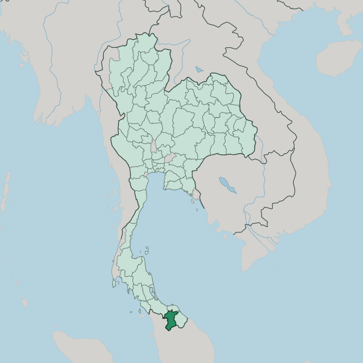


Towns & cities in Changwat Yala
Pick a town or city — each links to where to stay.
Yala keeps few beds, so plan around three anchors. The capital works best for a first stay. Its ring-road grid puts the central park, the markets and the Southern Line trains within a short walk, and the town feels calmer than the coast cities to the north.
Betong is the other draw. Its highland fog, hot springs and Chinese-Thai kitchens reward the long climb south. For the lake and forest, base at Bannang Sata below the Bang Lang Dam.
About Changwat Yala
What is Changwat Yala known for?
Yala sits at the far bottom of Thailand, one of just two southern provinces with no coastline. Mountains give Yala its shape, the Sankalakhiri Range walling the Malaysian frontier in forest. The Sankalakhiri Range walls the Malaysian frontier in forest, while the Pattani River threads north through the valleys and pools behind the Bang Lang Dam.
Betong draws travellers up to its fog-wrapped ridges. The capital, Yala, is one of the country's few planned cities, laid out in concentric rings. Most here are Malay-speaking Muslims.
Where is Changwat Yala?
Yala is the southernmost province of Thailand, and one of only two in the south with no coast, the other being Phatthalung. It reaches down like a wedge into the Malay Peninsula. Songkhla lies to the north-west, Pattani to the north, and Narathiwat to the east. Along the whole southern edge runs the border with Malaysia, against the states of Kedah and Perak.
No sea reaches it at all. Every frontier is either another province or a mountain ridge. That ridge is the Sankalakhiri Range, the northern reach of the Titiwangsa Mountains, and it climbs to its highest point at Ulu Titi Basah on the Malaysian line.
Dense rainforest covers much of the interior, protected in Bang Lang National Park and along the Hala-Bala corridor toward Narathiwat. The Pattani River is the province's spine of water, rising in these southern hills and running north toward the coast at Pattani, dammed midway in Bannang Sata to form the reservoir behind the Bang Lang Dam. Betong, the deep-south tip, sits roughly 140 km beyond the capital by a winding mountain road.
The land only gets steeper toward the south.
What is Changwat Yala like?
Yala belongs to the Malay world as much as to Thailand. More than four in five people here are Muslim, most of them speaking Pattani Malay at home rather than Thai. Village mosques, Islamic schools and Friday markets set the rhythm, and the food leans to the halal kitchens of the peninsula rather than to central-Thai cooking.
Signs often carry Jawi script beside Thai. The three southern border provinces together were once the heart of the old Patani realm. This is a border culture, shared with Kelantan and the states to the south.
Betong tells a different story again. Its old town grew up around Cantonese and Hokkien tin miners, and it keeps Chinese shrines, clan houses and a kitchen famous for herbal chicken and Betong-style dim sum. The hillside orchards around it are known nationwide for durian.
Yala city adds its own note each spring with a dove-cooing contest that draws breeders from across the peninsula and into Malaysia. Buddhist temples, Chinese shrines and mosques stand within a few streets of one another. Three faiths share the ground.
It is one of the more layered corners of the Thai south.
What is the history of Changwat Yala?
For centuries this was part of Patani, a Malay sultanate that rose on the peninsula by the 14th century. Siam broke that kingdom apart. Yala first appears as a separate mueang in 1808, when the old Patani realm was carved into seven small principalities under Bangkok's control.
Full annexation followed in 1902, and the Anglo-Siamese Treaty of 1909 drew the boundary with British Malaya that still separates Yala from Kedah and Perak.
What is the climate of Changwat Yala?
Yala runs hot and wet, in the tropical monsoon belt of the far south. There is no cool dry winter here. The heaviest rain arrives with the north-east monsoon late in the year, when downpours swell the Pattani River and flood the lowland paddies around the capital.
Betong is the exception. Up in the Sankalakhiri Range its mornings come wrapped in mist and its air stays noticeably cooler, which is how the town earned its name as a place of fog.
How do you get to Changwat Yala?
The train is the classic way in. The State Railway's Southern Line threads through the capital on its run toward Su-ngai Kolok, so through services from Bangkok and Hat Yai call at Yala station. Roads climb south from there.
Betong sits about 140 km deeper into the mountains, with its own airport and a border crossing into Perak in Malaysia. Most foreign visitors route through Hat Yai in Songkhla, the region's main air and rail hub.
Good for
Updated July 2026