Thailand
Changwat Phichit, Thailand — Towns & Travel Guide


Changwat Phichit is a flat, river-fed province of lower northern Thailand, where the Nan River crosses the plains that feed the Chao Phraya.
About Changwat Phichit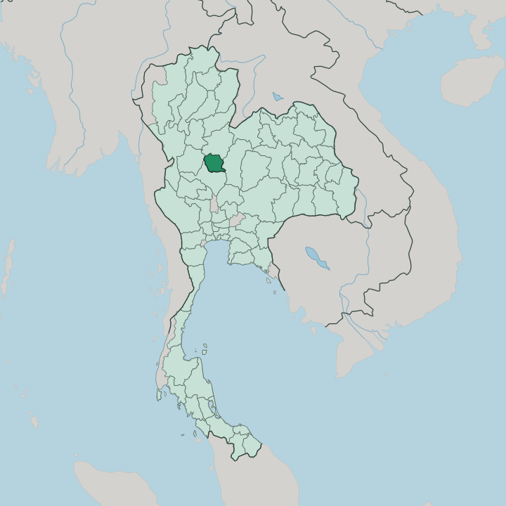


Towns & cities in Changwat Phichit
Pick a town or city — each links to where to stay.
Most beds sit in Phichit town itself, the provincial seat strung along the Nan River in Mueang Phichit. It is a modest place. Taphan Hin, the busier market town downstream to the south, is watched over by the tall golden Buddha Luang Pho To at Wat Thewaprasat and makes a practical second base for the pomelo orchards around Pho Prathap Chang and Bang Mun Nak.
Stay in Phichit town if you want the railway station, the river, and an easy stroll; pick Taphan Hin for trade and the fruit-growing south.
About Changwat Phichit
Rice and lotus fill the plains here.
What is Changwat Phichit known for?
Phichit is farm country, one of the lower north's quiet agricultural provinces, better known to Thais for its fruit and its folklore than for any skyline. The seedless pomelo grown around Pho Prathap Chang is the crop that carries its name to market stalls across the country. Its oldest story is darker: the man-eating crocodile king Chalawan, whose battle with the hunter Krai Thong was set in verse by a Siamese king and still names streets and shops in the provincial town.
Freshwater lakes such as Bueng Si Fai break the flat fields.
Where is Changwat Phichit?
Phichit lies in the lower north of Thailand, on the wide alluvial flats where the country's central plain begins. Where the central plain begins, Phichit lies on wide alluvial flats, its paddy running bank to bank between the Nan and the Yom. Two rivers order it, both running north to south: the Nan River down the east of the province and the Yom River to the west, their floodplains laid out in paddy almost from bank to bank.
Between and around them stretch the rice fields, the lotus ponds, and the oxbow lakes left by old river courses, of which Bueng Si Fai near the provincial town is the largest. Forest barely survives here; cultivation has taken nearly all of it. Four provinces enclose it. Phitsanulok sits to the north, Phetchabun to the east against the hills, Nakhon Sawan to the south, and Kamphaeng Phet to the west across the Yom.
South of Phichit the Yom slips quietly into the Nan, and the Nan runs on to meet the Ping at Nakhon Sawan, where the Chao Phraya is born and carries these waters down to Bangkok. The provincial town stands on the Nan, roughly a day's slow road north of Bangkok.
What is Changwat Phichit like?
Phichit's imagination runs to the water and the crocodiles in it. Its signature tale is Krai Thong, the verse drama King Rama II drew from local legend, in which the hunter Krai Thong dives into an underwater cavern to kill Chalawan, the crocodile lord who had carried off a merchant's daughter. The Siamese crocodile became the provincial emblem, and stone and concrete Chalawans guard road junctions and temple gates across the province.
Fruit does the rest of the talking. The seedless pomelo of Pho Prathap Chang and the lotus of the flooded fields anchor the local markets and the cooking, and a pomelo fair marks the harvest. History left a quieter mark.
Between the world wars the Vietnamese revolutionary Ho Chi Minh lived hidden among the Thai-Vietnamese of the province, organising against French rule in Indochina, and a memorial keeps that history. Temple life shapes the ordinary calendar. The wats of the old and new towns hold the ordinations, the merit-making, and the festivals, while the provincial seal shows the royal pond of Sa Luang behind the banyan of Pho Prathap Chang.
Devotion here is plain and daily.
What is the history of Changwat Phichit?
The town is old. Local tradition traces the first settlement, once called Sa Luang, the city of the royal pond, to the era before the Thai kingdoms took shape. It grew under the Sukhothai Kingdom and passed to the Ayutthaya Kingdom, when it went by Okhaburi, the town in the swamp, before the softer name Phichit, meaning beautiful, stuck.
The original site survives as Muang Kao, an old-city park of ruined brick southwest of the modern town. Wat Pho Prathap Chang stands apart from all this, west in the district that carries its name, the temple King Suea raised in 1701 at his reputed birthplace.
What is the climate of Changwat Phichit?
Phichit runs on a tropical savanna rhythm, split cleanly between wet and dry. The turn is the monsoon. From about April the southwest monsoon piles up heavy afternoon storms that fill the Nan and the Yom and leave the paddies standing in water deep into October.
April itself is the fierce, hazy peak of the heat, just before the rains break. Then the dry season settles in, cooler and clear, and the flooded fields drain back to stubble and dust. Nights in the cool months can feel almost sharp.
How do you get to Changwat Phichit?
Rail is the classic way in. Phichit sits on the State Railway of Thailand's northern line between Bangkok and Chiang Mai, and the sleeper and day trains that run up the country stop at both Phichit town and Taphan Hin. By road it is a long but straightforward haul north from Bangkok, on the highways that shadow the railway through the central plain.
The nearest airport with scheduled flights is up the line at Phitsanulok, an hour or so to the north. From there it is a short hop down to the Nan.
Good for
Updated July 2026