Argentina
Neuquén Province, Argentina — Towns & Travel Guide


Neuquén Province anchors the north of Patagonia, running from the arid Argentine steppe up to the volcanoes and lakes of the Andes.
About Neuquén Province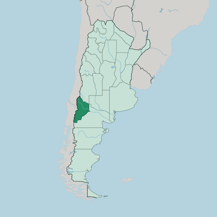
Towns & cities in Neuquén Province
Pick a town or city — each links to where to stay.
West or east, the choice is stark. San Martín de los Andes, on the shore of Lácar Lake, is the classic base for Lanín National Park and the Chapelco ski runs above town. Villa La Angostura sits further south on Nahuel Huapi Lake, the other end of the Ruta de los Siete Lagos, and it puts the arrayán forest and the Cerro Bayo slopes within reach.
Neuquén city, where the Limay and the Neuquén rivers join, is the practical base for the vineyards and the dinosaur country of the eastern plateau. Pick the Andean towns for lakes and snow; pick the capital for the steppe.
About Neuquén Province
What is Neuquén Province known for?
Neuquén is Patagonia's lake country. Along the Andes in the west, a chain of glacial lakes and Araucaria forests runs south through Lanín and Nahuel Huapi national parks, and the paved Ruta de los Siete Lagos threads between them. San Martín de los Andes and Villa La Angostura are the towns most travellers base themselves in.
The dry eastern steppe tells a different story: Vaca Muerta shale under the plateau, vineyards on the Neuquén River, and Cretaceous dinosaur beds around Villa El Chocón. Two worlds share one province.
Where is Neuquén Province?
Neuquén fills the northwest corner of Patagonia, in the west of Argentina. Its shape is drawn by water and rock. The Andes form the whole western edge, the frontier with Chile, and their crest carries the Lanín volcano and a run of glacial lakes down to Nahuel Huapi Lake.
To the north, the Colorado River separates the province from Mendoza Province and marks the top of Patagonia. The Limay River traces the southern boundary against Río Negro Province, then joins the Neuquén River at the eastern tip, and the two combine into the Río Negro. Between those rivers the land dries out fast.
The contrast is stark. West of the Andean forests the province is high, wind-scoured steppe, a basalt and scrub plateau cut by canyons and by the odd irrigated valley. Neuquén city stands at the far eastern tip, at the confluence that gives its Confluencia department its name, while the resort towns cluster in the wet southwest.
Volcanoes to plateau, it packs Andean rainforest and near-desert into one of Patagonia's broader provinces.
What is Neuquén Province like?
Two cultures meet in Neuquén. The Mapuche were here long before the province was, and their communities still hold land along the Andean lakes and in the northern valleys; place names like Aluminé, Lácar and Huechulafquen are Mapudungun, and their weaving, music and pehuén-nut harvest carry on in the western towns. Spanish is the everyday language of the province.
Alongside it you hear Mapudungun in the Andean communities, a reminder that this was Mapuche ground first. The eastern half feels newer and rougher. Neuquén city grew up around the railway and the confluence, then around oil, and its energy money now flows from the Vaca Muerta shale under the plateau.
That wealth sits beside older Patagonian habits: mate passed round, asado over coal, small wineries on the Neuquén River turning out Malbec and Pinot Noir near San Patricio del Chañar. The province leans hard into its Cretaceous past, too. Around Villa El Chocón the giant carnivore Giganotosaurus was dug from the rock, and the fossil trail is a point of local pride.
What is the history of Neuquén Province?
For centuries this was Mapuche and Tehuelche land, beyond the reach of the Argentine state. Then the army came. The Conquest of the Desert, the military campaign of 1879 to 1885, seized northern Patagonia and folded it into the republic.
The land became the National Territory of Neuquén, governed first from Chos Malal, founded in 1887 up in the northern mountains. In 1904 the capital moved east to the young railway town of Neuquén, at the river confluence. Only in 1955 did the territory finally become a full province of Argentina.
What is the climate of Neuquén Province?
Two climates share the province, split by the Andes. The high western valleys around San Martín de los Andes are cool and wet, feeding the temperate rainforest and holding snow on the Chapelco and Cerro Bayo runs through the southern winter. East of the mountains the picture flips: the Neuquén steppe is dry, sunny and swept by a hard, constant wind, watered only where the Limay and Neuquén rivers cut through.
Winters bite everywhere. The peaks stay white while the plateau turns brown.
How do you get to Neuquén Province?
Two airports serve the province. Neuquén city, at the eastern confluence of the Limay and Neuquén rivers, has the busier one, plus the main road and rail links out into Patagonia. For the lake country, San Martín de los Andes flies into its own field at Chapelco, far closer to Lanín National Park and the Ruta de los Siete Lagos.
National Route 40 runs the length of the Andes, tying the resort towns together and carrying the paved Seven Lakes drive down to Villa La Angostura and on into Río Negro Province.
Good for
Updated July 2026