Brazil
Roraima, Brazil — Towns & Travel Guide


Roraima is Brazil's northernmost state, a frontier of savanna and Amazon rainforest on the Rio Branco, bordering Venezuela and Guyana.
About Roraima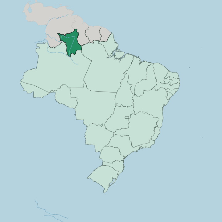
Towns & cities in Roraima
Pick a town or city — each links to where to stay.
Almost every visit to Roraima runs through Boa Vista, the state capital laid out as an open fan of avenues on the west bank of the Rio Branco. It holds the airport, the bus terminal and nearly all the beds. From there the state splits by terrain.
North toward Pacaraima the savanna rises into the tepui highlands along the Venezuela border, while the Rio Branco valley and the southern forests stretch away toward Amazonas. Base yourself in Boa Vista; treat the border towns and the lavrado as day-country beyond it.
About Roraima
What is Roraima known for?
Roraima takes its name from Mount Roraima, the tallest of the flat-topped tepuis standing where Brazil, Venezuela and Guyana come together at one shared summit. The state fills Brazil's far north. Around the capital at Boa Vista the land opens into the lavrado, a woodland savanna grazed by cattle that looks nothing like the dense forest most travellers expect of the Amazon.
The Rio Branco threads through the middle. Cattle country, indigenous homelands and table-mountain horizons share the same wide sky.
Where is Roraima?
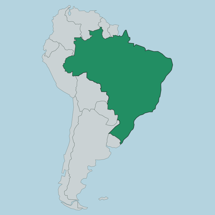
Roraima sits at the very top of Brazil, the only state that lies entirely north of the equator. It is the country's northernmost and least populous state. To the north and west it borders Venezuela, and to the east Guyana, so two international frontiers wrap most of its edge.
Southward it meets the Brazilian state of Amazonas, with a short border against Pará in the south-east. The land climbs from the forested lowlands of the south toward the Guiana Highlands in the north, a worn shield of ancient rock. Out of that shield rise the tepuis, sheer-walled table mountains, and the tallest of them, Mount Roraima, marks the point where Brazil, Venezuela and Guyana meet.
Water organises everything here. The Rio Branco gathers the state's rivers and runs south to join the Rio Negro, which in turn feeds the Amazon. Around Boa Vista, on the river's west bank, the forest gives way to the lavrado, the largest block of savanna in the northern Brazilian Amazon.
Streams like the Cotingo fall from the foot of Mount Roraima, and the Maú, or Ireng, traces part of the boundary with Guyana. Forest in the south, grassland in the middle, table mountains in the north. That is Roraima in one breath.
What is Roraima like?
Roraima is a frontier in the old sense, a place people came to rather than a place with deep colonial roots. Long before ranchers and gold-seekers arrived, the savanna and forest belonged to the Macushi, the Wapishana, the Taurepang and the Yanomami, and those peoples still hold large demarcated territories across the state. The Yanomami lands stretch through the forested south and west toward Venezuela; the Macushi and Wapishana keep to the grassland of the north-east, including the Raposa Serra do Sol reserve.
Cattle ranching set the tone of settler life on the lavrado, and the figure of the vaqueiro, the savanna cowhand, still shapes how the state pictures itself. Portuguese is the common language, spoken alongside Macushi, Wapishana and other indigenous tongues. Boa Vista anchors it all.
Laid out by a single architect as a fan of avenues spreading from the Rio Branco, it is one of Brazil's few fully planned capitals, and its riverfront, the Orla Taumanan, is where the city gathers in the evening cool. Food leans on the rivers and the herds: freshwater fish from the Rio Branco, beef from the lavrado, and dishes carrying Caribbean and indigenous notes rather than the flavours of the Brazilian coast. It is Brazil, but seen from its far northern edge.
What is the history of Roraima?
For most of its history this was simply the far edge of Amazonas, the upper basin of the Rio Branco. Brazil split it off in 1943 as a federal territory, first called Rio Branco and then renamed for Mount Roraima. Statehood came late.
Only in 1988 did Roraima become a full state of the Brazilian federation, one of the last territories to be raised to that rank. The decades around statehood were marked by gold rushes that drove thousands of garimpeiros onto Yanomami land, and the fallout of that invasion still shapes the state's politics.
What is the climate of Roraima?
Roraima is hot the year round, sitting north of the equator in the tropics. Its rhythm is set by rain, not temperature. Across the forested south and west the climate is equatorial, wet through most of the year, while the northern lavrado around Boa Vista has a sharper split between a rainy season and a dry one.
Oddly for the Amazon, the wet months here fall roughly from April into September, the reverse of the pattern further south. The dry season bakes the savanna brown. Rivers like the Rio Branco swell and shrink with that calendar, and the grassland turns green only when the rains return.
How do you get to Roraima?
Roraima is Brazil's most out-of-the-way state to reach, and almost everyone arrives through Boa Vista. Its airport, named for Atlas Brasil Cantanhede, is the northernmost in Brazil with scheduled service, linked mainly by flights up from Manaus. By land there is essentially one road.
The BR-174 highway runs the length of the state, south through the forest to Manaus in Amazonas and north to Pacaraima on the Venezuelan border. A second paved road, the BR-401, heads east to Bonfim, where the Takutu River bridge crosses into Lethem in Guyana. There is no railway and no coast.
Good for
Updated July 2026