Democratic Republic of the Congo
Province du Sud-Ubangi, Democratic Republic of the Congo — Towns & Travel Guide


Sud-Ubangi is a province in the far north-west of the Democratic Republic of the Congo, named for the Ubangi River on its edge.
About Province du Sud-Ubangi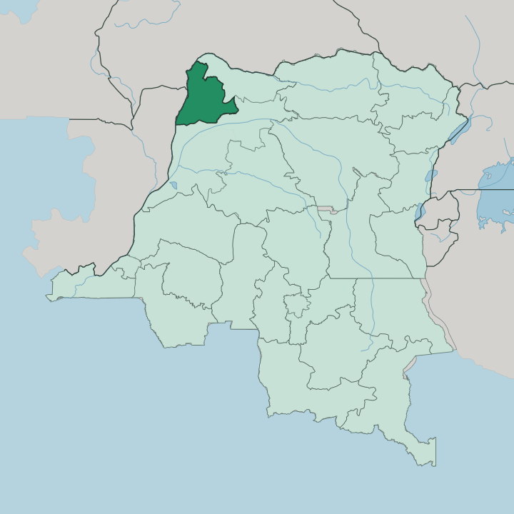


Towns & cities in Province du Sud-Ubangi
Pick a town or city — each links to where to stay.
Gemena is the practical base. As the capital it holds the province's administration, its market trade and its airfield, so most travel through Sud-Ubangi starts and ends there. Zongo is the alternative, a border town on the south bank of the Ubangi facing Bangui, useful only if your reason for coming is the crossing itself.
Libenge, an old river post downstream, is quieter still. If you want the province's services and its onward links, base yourself in Gemena; choose Zongo when the Central African Republic frontier is the point.
About Province du Sud-Ubangi
The province is a river province.
What is Province du Sud-Ubangi known for?
The Ubangi runs along its whole northern and western edge, dividing the Democratic Republic of the Congo from the Central African Republic and, further downstream, the Republic of the Congo. Gemena, the inland capital, is the trading and administrative centre, while Zongo sits on the water directly across from Bangui. Cassava, maize, coffee and oil palm come off the surrounding land.
It is one of the country's newer provinces, carved out of the old Équateur in the 2015 reorganisation.
Where is Province du Sud-Ubangi?
Sud-Ubangi occupies the far north-west of the Democratic Republic of the Congo, one of the country's most distant corners from the capital in Kinshasa. Its whole outer edge is water. The Ubangi River curves along the north and west of the province, and that river is the international border.
Across it to the north lies the Central African Republic, and where the Ubangi swings south the far bank becomes the Republic of the Congo. The Ubangi itself is the largest right-bank tributary of the Congo, formed upstream at the meeting of the Uele and Mbomou rivers before it runs this way. Inland the ground is low, flat and green, part of the vast equatorial basin, with rainforest and cultivated clearings rather than mountains.
Gemena, the capital, sits back from the river in this interior. Zongo lies on the bank opposite Bangui, and rapids there break the water and the shipping. Libenge and the other river posts string out downstream.
The province was cut from the former Équateur in 2015, and it borders the newer Nord-Ubangi and Mongala provinces on its Congolese sides. It covers roughly 51,648 square kilometres of this well-watered north-western land.
What is Province du Sud-Ubangi like?
Life here is bound to the land and the river. Most people farm the surrounding fields and forest, raising cassava and maize for the pot alongside coffee and oil palm for trade, and the weekly markets of Gemena pull that produce together. The Ngbaka are the largest of the local peoples, and Ngbaka is the everyday tongue in Gemena and the villages around it, spoken by hundreds of thousands.
Other communities line the middle Ubangi. French is the official language and Lingala the shared river language of the whole north-west, carried along the water, through the markets and over the radio. Christianity took deep hold in the province.
Catholic and Protestant missions came up the Ubangi during the colonial period and their churches remain central to town life, from Gemena down to Libenge. Culture here is rural more than urban. It sits in the drum and dance traditions of the Ngbaka, in the food drawn from cassava and the forest, and in the rhythm of planting and harvest that a tropical wet season sets.
This is not a place of monuments or old cities. Its character is the working life of a river-and-forest province, close to the frontier with the Central African Republic.
What is the history of Province du Sud-Ubangi?
The province is young. Colonial administration first pushed up the Ubangi in the late nineteenth century, planting river posts at Zongo, Libenge and other landings to hold the frontier with the French territories across the water. Those posts, and the trade in coffee and oil palm that grew around them, shaped the region for a century as part of a much larger Équateur.
In 2015 the Democratic Republic of the Congo broke that old province apart, and Sud-Ubangi became a province in its own right, with Gemena raised to capital.
What is the climate of Province du Sud-Ubangi?
Sud-Ubangi is hot and wet the whole year. It sits deep in the equatorial belt, so temperatures barely move from month to month and the air stays heavy. The year splits into a long rainy stretch and a shorter drier one rather than into warm and cold.
Rain builds through the middle of the year and the heaviest storms fall late, roughly from August into October, when the Ubangi runs high and low ground around Zongo and Libenge can flood. Expect green, humid and thundery weather.
How do you get to Province du Sud-Ubangi?
Reaching Sud-Ubangi means either flying or coming up the river. Gemena has the province's main airport, and in a country where roads are poor and distances enormous, air is the usual way in from Kinshasa and the rest of the Democratic Republic of the Congo. The other route is the water.
Boats work the Ubangi, and Zongo is a recognised crossing point straight over from Bangui in the Central African Republic. Overland, the RN6 highway threads Zongo, Libenge and Gemena together, though the going is slow and seasonal.
Updated July 2026