Iran
Kohgiluyeh and Boyer-Ahmad Province, Iran — Towns & Travel Guide


Kohgiluyeh and Boyer-Ahmad is a mountainous Zagros province of south-western Iran, its capital Yasuj set among oak forests below the Dena peaks.
About Kohgiluyeh and Boyer-Ahmad Province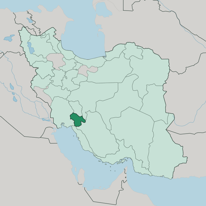
Towns & cities in Kohgiluyeh and Boyer-Ahmad Province
Pick a town or city — each links to where to stay.
Lodging concentrates in three towns. Yasuj, the capital, is the natural base for the Dena and the mountain valleys, and almost every trip into the high country starts there. Dogonbadan lies south in the warmer oil country of Gachsaran County, while Dehdasht anchors the older western lowlands of Kohgiluyeh County.
Choose Yasuj if you want the peaks and the forest within reach; choose the plains for the province's warmer, drier side.
About Kohgiluyeh and Boyer-Ahmad Province
Mountains define this province.
What is Kohgiluyeh and Boyer-Ahmad Province known for?
It is one of Iran's least urban corners, a stack of Zagros ridges where the Dena massif rises to a snow-covered summit and oak forest climbs the slopes above Yasuj. Rivers such as the Zohreh and the Khersan cut through the ranges toward the plains. The Lurs of the Boyer-Ahmad tribe give the province its name, herders and weavers whose felt rugs and carpets are made across the valleys.
Summer draws walkers to the waterfalls; winter brings snow to the passes.
Where is Kohgiluyeh and Boyer-Ahmad Province?
Kohgiluyeh and Boyer-Ahmad sits in south-western Iran, a wedge of the central Zagros between the high interior and the Persian Gulf lowlands. Five provinces wrap around it. Isfahan Province and Fars Province lie to the east, Bushehr Province to the south, Khuzestan Province to the west, and Chaharmahal and Bakhtiari Province along the northern edge. The land is almost entirely mountain.
Parallel Zagros ridges run north-west to south-east across it, and the Dena massif crowns the north-east, its highest ridge topping out above the oak forests at the province's tallest point. Yasuj, the capital, sits in a valley on the northern side of that range. Water drains off these mountains in every direction.
The Zohreh and its tributaries gather in the south and west, the Khersan runs off the northern heights toward the Karun system, and smaller rivers like the Bishar thread past Yasuj itself. Elevation, not distance, sets the province apart. Yasuj stands well over a kilometre and a half above the sea, while the western towns around Dehdasht and the oil fields near Dogonbadan drop toward the hot Khuzestan plain.
That fall from cold peaks to warm lowland, over just a few dozen miles, is the whole shape of the place.
What is Kohgiluyeh and Boyer-Ahmad Province like?
This is Lur country. The province takes its name from the Boyer-Ahmad, one of the Lur tribes that have grazed these Zagros valleys for centuries, and their world still sets the tone. Most people speak Southern Luri, a south-western Iranian tongue close to Persian but distinct enough that outsiders need an ear for it.
Tribal loyalties run alongside the modern map of counties and towns. Many families kept up seasonal migration well into living memory, driving flocks up to the Dena pastures in summer and down to the warm plains in winter, and that herding life shaped the crafts, the food, and the music. Handwork carries the culture.
Women weave carpets, jajim, and thick felt from the wool of the flocks, patterns that vary from valley to valley. Nowruz, the Persian new year at the spring equinox, is the great festival, marked here with its own customs and sweets. Wrestling, horsemanship, and stick dances belong to the tribal gatherings.
Food leans on dairy, flatbread, and lamb, the plain diet of a herding people. For all the oil money that flows through Dogonbadan and Gachsaran County, the province stays rural, conservative, and tied to the land in a way much of Iran no longer is.
What is the history of Kohgiluyeh and Boyer-Ahmad Province?
Tribes ran this land. The Boyer-Ahmad and the Kohgiluyeh rose to real power under the Qajar shahs, holding the Zagros passes between Fars and Khuzestan and bowing to central rule only when forced. The Pahlavi state broke that autonomy and settled the herders.
Their lands were parcelled out to neighbouring provinces until 1976, when the two old districts were joined as one province named for them, and the small town of Yasuj was built up to be its capital.
What is the climate of Kohgiluyeh and Boyer-Ahmad Province?
Two climates share the province. Up around Yasuj and the Dena, the high Zagros brings cold, snowy winters and short mild summers, with enough snowpack to feed the rivers and even a little skiing. Drop west and south toward Dehdasht and Dogonbadan and the pattern flips: long hot summers, mild winters, and the dry, semi-arid air of the Khuzestan borderlands.
Most of the rain and snow falls in the cold months. Summers stay bone-dry.
How do you get to Kohgiluyeh and Boyer-Ahmad Province?
Nearly everyone arrives by road. Yasuj Airport runs a thin schedule of flights to Tehran and a handful of Iranian cities, with a second airstrip out at Dogonbadan. The usual approach climbs the Zagros by road, up from Isfahan to the north, in from Shiraz and Fars to the south-east, or from the Khuzestan lowlands to the west.
Snow can shut the high passes in winter. No rail line reaches Kohgiluyeh and Boyer-Ahmad, so every arrival comes by road or the thin flights into Yasuj.
Good for
Updated July 2026