Iran
Bushehr Province, Iran — Towns & Travel Guide


Bushehr Province is Iran's long Persian Gulf coast, from the old port of Bushehr south to the gas terminals at Asaluyeh.
About Bushehr Province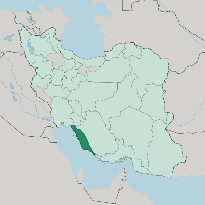
Towns & cities in Bushehr Province
Pick a town or city — each links to where to stay.
Bushehr is the natural first base. The port capital has the province's widest choice of rooms and an old coral-stone quarter to walk at dusk. Inland, Borazjan makes a working base among the date palms of Dashtestan, close to the Achaemenid ruins at Bardak Siah.
Bandar Ganaveh anchors the northern shore near the Khuzestan line. The far south is different: around Kangan and Asaluyeh the beds are built for gas engineers, though the ruined port of Siraf lies just up the coast. Choose Bushehr for a first visit; head down the shore only if the sea and the ruins pull you.
About Bushehr Province
Two things define this coast: the sea and the gas.
What is Bushehr Province known for?
The Persian Gulf sets the tone all along the shore, from the fishing quays to Ghalieh Mahi, the tamarind-dark fish stew that turns up on tables from Ganaveh to Dayyer. Bushehr, the port capital, hides a warren of old coral-stone houses behind its waterfront. Dates rule inland.
The palm groves around Borazjan are among the densest in Iran. Bandari music, driven by the Ney Anban bagpipe and goblet drums, is the sound of the province. Far south at Asaluyeh, the South Pars gas field feeds a refinery sprawl.
Where is Bushehr Province?
Bushehr Province is the long southern coast of Iran on the Persian Gulf. It runs as a narrow ribbon for hundreds of kilometres, wider than any single town, hemmed between the water and the hills. Khuzestan lies to the north-west and Kohgiluyeh and Boyer-Ahmad to the north, Fars fills the eastern horizon, and Hormozgan takes over where the coast bends south-east.
Everywhere else is sea. The land itself splits in two. A flat coastal plain of date groves, tidal creeks and salt flats runs the length of the shore, then rises into the bare limestone foothills of the southern Zagros that locals call the Gachtorsh heights.
Two rivers cross that plain to reach the Gulf. The Helleh, formed where the Shapur and Dalaki come down off the Zagros, spreads into a broad delta of marsh and mudflat just north of Bushehr city. Further south the Mand, one of the longest rivers in Iran, runs salty from the ground it crosses before it empties near Dayyer.
Bushehr city sits on a low peninsula that noses out into the Gulf. Salt domes such as Jashak push up through the plain further south. At Nayband Bay, near the gas town of Asaluyeh, mangroves hold the largest such stand on this side of the country.
The province covers about 22,743 square kilometres, but almost all of its life clings to the coast road and the water.
What is Bushehr Province like?
Life here faces the sea. The coast has its own soundtrack, Bandari music, propelled by the reedy Ney Anban bagpipe, goblet drums and the deep dammam played at weddings and at the Ashura mourning. Centuries of dhow trade across the Gulf left an African pulse in those rhythms that sets Bushehri music apart from anything in the Iranian interior.
People sing at sea and sing on land. The result is quick, percussive and impossible to mistake for anywhere else in Iran. The table is built on the sea and the palm.
Ghalieh Mahi, a dark fish stew thickened with tamarind, fenugreek and fistfuls of garlic, is the dish the province is judged by, and every family guards its own version. Dates from the Dashtestan groves sweeten everything else. Shrimp and the day's catch turn up grilled, stewed or dried.
The old town of Bushehr is the clearest record of all this. Its four quarters, Behbahani, Dehdashti, Kooti and Shanbedi, are a maze of tall houses built from Gulf coral-stone, their fronts opened up by carved wooden shanashir balconies and topped by badgir windcatchers that pull in the sea breeze. Much of the timber is teak, shipped in from India in the trading years.
Persian is the common tongue, but the southern accent is broad and salted with Arabic picked up across generations of Gulf commerce.
What is the history of Bushehr Province?
People have worked this coast since the Elamite age. At Rishahr, just south of Bushehr, the ancient port of Liyan traded with Mesopotamia long before the Persians. The Achaemenids left winter palaces on the plain near Borazjan.
Then came Siraf. That Gulf port grew rich under the Abbasids, sending ships to India and China until an earthquake broke it. Bushehr itself stayed a fishing village until 1734, when Nader Shah made it the base of his new Persian Gulf fleet, and British traders and their residency soon followed.
What is the climate of Bushehr Province?
Summers on this coast are brutal. From May to October the Persian Gulf turns the air thick and wet, and the heat sits heavy over Bushehr and the ports for weeks on end. Winters are the reward, mild and bright, which is why travellers come between November and March.
What little rain falls comes in those winter months, run off the Zagros in short bursts. Dust blows in off the plain. The sea keeps the nights close and humid even when the sun is down.
How do you get to Bushehr Province?
Two airports serve the coast. Bushehr, the port capital, has an international field whose runway takes domestic flights from Tehran and Shiraz. Far south at Asaluyeh, the Persian Gulf Airport was built for the South Pars gas zone and runs its own daily flights to Tehran, Shiraz and Isfahan.
The overland alternative is the drive down from Shiraz, in Fars, off the Zagros to the sea. One coastal highway then threads the whole province, linking Bandar Ganaveh in the north through Bushehr to Kangan and Asaluyeh in the south. The old port still works, but it moves cargo, not passengers.
Good for
Updated July 2026