Japan
Nagasaki Prefecture, Japan — Towns & Travel Guide


Nagasaki Prefecture is Japan's far-western edge, its harbour peninsulas and islands scattered across the Korea Strait and the East China Sea.
About Nagasaki Prefecture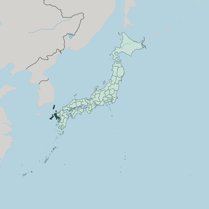


Towns & cities in Nagasaki Prefecture
Pick a town or city — each links to where to stay.
Nagasaki city is the natural first base. The capital rings its harbour with hills, and the trams reach Dejima, Chinatown and Glover Garden without much walking. North of it, Sasebo opens onto the Kujūkushima islands and the Dutch-built streets of Huis Ten Bosch.
For hot springs, inns cluster on the Shimabara Peninsula below Mount Unzen. The outer islands, Gotō, Iki and Tsushima, reward a night for their churches and beaches, though the ferries run long and rooms thin outside the main ports.
About Nagasaki Prefecture
What is Nagasaki Prefecture known for?
Two things fix the prefecture in the mind: faith and foreign trade. For more than two centuries the man-made island of Dejima in Nagasaki was the only door Japan left open to the West, where Dutch ships tied up under strict watch. Christianity took root here early and was driven underground, leaving the Hidden Christian villages that later drew UNESCO recognition.
The city carries a harder memory. It was the target of the second atomic bomb, in 1945. Beyond the mainland, Tsushima and Iki step out toward Korea while the Gotō Islands trail into the East China Sea.
Where is Nagasaki Prefecture?
Nagasaki Prefecture sits at the far western edge of Japan, on the northwestern corner of Kyūshū. Its shape is almost all coast. Deep bays and slender peninsulas break the mainland into fingers of land, while Ōmura Bay lies nearly landlocked at the centre, linked to the open sea by one thin strait.
The Shimabara Peninsula bulges to the southeast, carrying the andesite cone of Mount Unzen, whose lava dome loosed deadly pyroclastic flows in 1991 and whose 1792 collapse sent a tsunami across the Ariake Sea. West of it the narrower Nagasaki Peninsula reaches toward the harbour city. The Ariake Sea washes the eastern shore, and only in the northeast does the land run on unbroken, into Saga Prefecture, the one border it has by ground.
Everything else is islands. The prefecture counts 1,479 islands, the largest number of any in Japan, from bare rocks to inhabited ports. Tsushima and Iki rise in the Korea Strait, nearer the Korean Peninsula than to much of the country, long used as stepping stones between the two.
The Gotō chain scatters west into the East China Sea, its inlets sheltering old Christian villages. The coastline folds and refolds through all of it. Traced around every island and inlet, it ranks among the longest and most broken shorelines of any Japanese prefecture.
What is Nagasaki Prefecture like?
The prefecture's long turn as Japan's one open port shaped a culture found nowhere else in the country. Portuguese, Dutch and Chinese traders each left a mark. It shows first at the table.
Castella, the honey-coloured sponge cake, came with Portuguese missionaries; the noodle dishes champon and sara-udon grew out of the Chinese quarter; and shippoku sets Japanese, Chinese and European courses on one shared table. The Nagasaki Kunchi, the autumn festival of the harbour city, still parades Chinese dragons and a Dutch ship through the streets, and the winter Lantern Festival floods the old Chinatown with colour. Faith runs just as deep.
Christianity reached these shores in the sixteenth century, was banned for over two hundred years, and lived on in secret among the Hidden Christians of the Gotō and Sotome coasts. Their churches, among them Ōura, the oldest in Japan, hold a place on the UNESCO World Heritage list. The Japanese spoken here is ordinary enough.
Yet the old quarters keep Chinese temples, Dutch trading walls and Catholic spires within sight of one another, and on the northern coast Huis Ten Bosch rebuilds a whole Dutch town in brick and canal.
What is the history of Nagasaki Prefecture?
The modern prefecture was drawn in 1869, joining the western half of old Hizen Province to the island provinces of Tsushima and Iki. Its port has a longer story. Nagasaki opened to Portuguese ships in 1571 and soon became Japan's chief Christian town, until the faith was crushed and the country sealed shut.
Through more than two centuries of isolation, the Dutch post on Dejima stayed the one licensed link to Europe, from 1641 onward. Then the ships returned, and in 1945 the second atomic bomb fell on the city.
What is the climate of Nagasaki Prefecture?
Nagasaki keeps a warm, maritime climate, softened on every side by the sea. Summers turn hot and wet. The rains of the early-summer tsuyu soak the whole region through June, and from late summer into autumn typhoons swing up out of the East China Sea to lash the coast and the Shimabara slopes.
Winters stay mild by Japanese standards, and hard frost seldom grips the lowlands. Snow rarely settles on the harbour.
How do you get to Nagasaki Prefecture?
Most visitors land at Nagasaki Airport, built out on a reclaimed island in Ōmura Bay. Flights come in from Tokyo, Osaka and Fukuoka. By rail, the Nishi-Kyūshū Shinkansen has run into Nagasaki since 2022, though the line is short and still forces a change of trains at Takeo-Onsen in Saga.
The outer islands take more effort. Ferries and small propeller planes reach Tsushima, Iki and the Gotō chain from the mainland ports.
Good for
Updated July 2026