Japan
Saitama-ken, Japan — Towns & Travel Guide


Saitama is an inland prefecture just north of Tokyo, commuter cities on the Kantō plain, forested Chichibu Mountains behind.
About Saitama-ken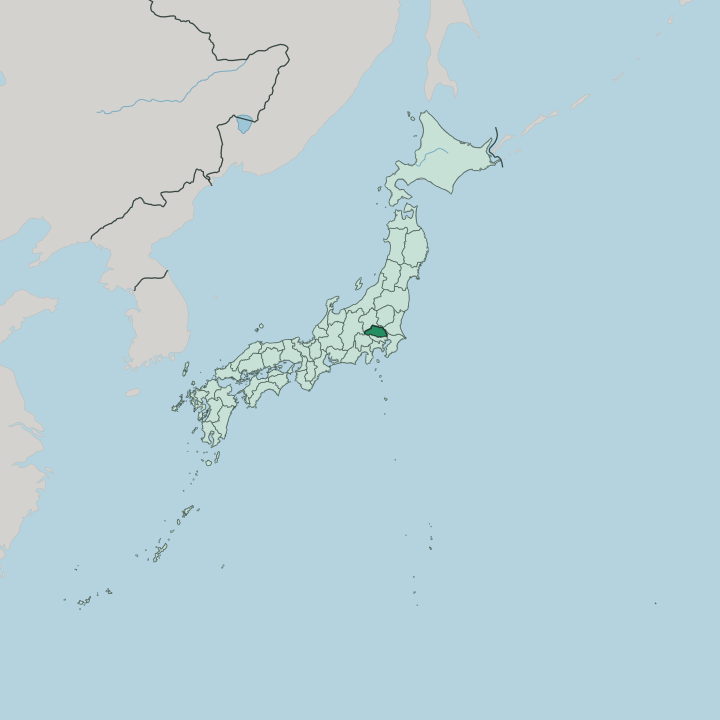


Towns & cities in Saitama-ken
Pick a town or city — each links to where to stay.
Base yourself beside the trains. Ōmiya, inside Saitama city, is the practical hub, where shinkansen and commuter lines converge beside the Railway Museum. Kawagoe suits anyone drawn to the old warehouse streets and the Bell of Time. Chichibu is the mountain choice, a valley town of hot springs and Shinto shrines set where the Arakawa river rises out of the surrounding peaks.
For the cheapest beds you can sleep in the southern suburbs around Kawaguchi and ride one stop into Tokyo. Pick the base that matches your day.
About Saitama-ken
What is Saitama-ken known for?
Most of Saitama reads as Tokyo's northern suburb, yet the prefecture keeps landmarks entirely its own. Kawagoe is the headline. Its Edo-period warehouse street, the kurazukuri quarter beneath the Toki no Kane bell tower, earns the nickname Little Edo and pulls day-trippers up from the capital in half an hour. Ōmiya adds the Railway Museum and an old bonsai village of working nurseries, while Chichibu supplies mountains, gorges, and one of Japan's great winter float festivals.
Trains tie it all together.
Where is Saitama-ken?
Saitama sits inland, one of the few Japanese prefectures with no coastline at all. It fills the middle of the Kantō region on the island of Honshu, directly north of Tokyo and hemmed in by mountains and rivers rather than sea. The land splits cleanly in two.
Roughly two-thirds of it, the eastern and central part, is flat Kantō plain, a low sweep of paddies, plateaus and packed commuter towns. The western third rises abruptly into the Chichibu Mountains, a forested upland of gorges and peaks climbing to Mount Sanpō, the prefecture's highest point. That contrast defines everything here.
Water draws the borders. The Tone river, which drains the largest basin in Japan, runs along much of the northern edge against Gunma and Ibaraki, while the Arakawa cuts down out of the Chichibu highlands and threads southeast through the plain toward Tokyo Bay. Beyond those two lines lie the neighbours. Tochigi and Gunma lie to the north, Nagano and Yamanashi across the western ridges, Tokyo and Chiba to the south, Ibaraki to the east.
Nothing here is far from a rail line. The prefecture measures barely a hundred kilometres end to end, yet packs mountain wilderness and dense suburb into that short span.
What is Saitama-ken like?
Culture in Saitama gathers around its old towns and its festivals. Kawagoe is the showpiece. Its kurazukuri street of clay-walled merchant storehouses survived the fires that erased most Edo-era architecture elsewhere, and the wooden Toki no Kane bell tower still marks the hours over it.
Locals call the town Little Edo for good reason. Sweet-potato sweets, a candy alley called Kashiya Yokochō, and the great Kawagoe Festival with its towering wheeled floats all belong to that same heritage of the merchant town. The language spoken here is Japanese, as across the country.
Beyond Kawagoe, tradition takes other forms. Ōmiya, a district of Saitama city, holds a bonsai village where growers relocated from Tokyo after the 1923 earthquake and laid out nurseries of miniature trees along quiet back lanes. Chichibu stages the Chichibu Yomatsuri each December, a night procession of lantern-lit floats and fireworks recognised by UNESCO. Trains are their own culture here.
The Railway Museum at Ōmiya keeps a hall of retired locomotives and shinkansen, and rail buffs treat it as a pilgrimage. Craft, festival and railway sit side by side.
What is the history of Saitama-ken?
For most of its past this land was Musashi Province, the old domain that also held Edo, the castle town that became Tokyo. Highways mattered here. The Nakasendō, one of the great Edo-period post roads inland to Kyoto, ran through Urawa, Ōmiya and Kumagaya, and their post stations grew into towns.
Saitama Prefecture itself dates only to 1871, drawn up in the Meiji reforms that abolished the feudal domains, with its seat fixed at Urawa. A century of Tokyo's outward spread did the rest.
What is the climate of Saitama-ken?
Saitama has a hot-summer inland climate, sharpened by having no sea to soften it. Summers are brutal on the plain. Kumagaya, out on the open lowland, has logged some of the highest temperatures ever recorded in Japan, and the humid heat sits over the Kantō basin for weeks.
Winters swing the other way, cold and dry, with the mountains often clear and frost on the plain under a hard blue sky. Up in the Chichibu highlands the air stays cooler through the year, and snow can settle on the peaks while the lowland towns rarely see any.
How do you get to Saitama-ken?
Reaching Saitama means reaching Tokyo first. The prefecture has no airport of its own, so most visitors land at Haneda or Narita and ride the rail net north. That net is dense. Ōmiya Station, in Saitama city, is the key junction, where several shinkansen lines fan out toward Tōhoku, Niigata and Nagano and commuter trains thread back into central Tokyo.
Kawagoe and Chichibu each hang off their own private lines from the capital. Expressways cover the gaps by road.
Good for
Updated July 2026