Kenya
Marsabit, Kenya — Towns & Travel Guide


Marsabit is Kenya's second-largest county, a desert north where forested Mount Marsabit rises green above the salt flats of the Chalbi Desert.
About Marsabit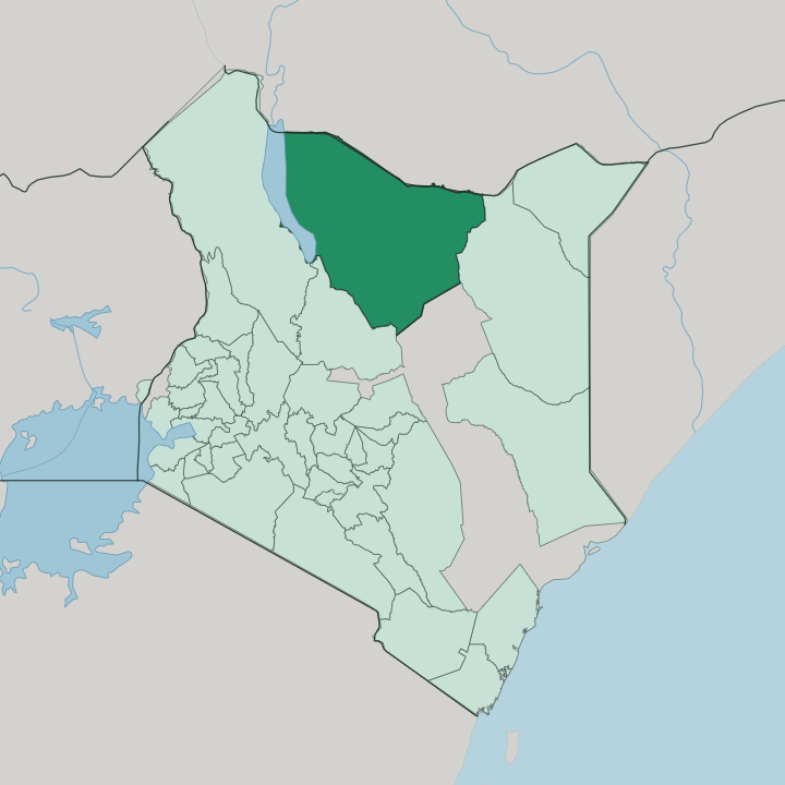


Towns & cities in Marsabit
Pick a town or city — each links to where to stay.
Marsabit town is the practical base. It sits high in the cool forest of Mount Marsabit, within reach of Marsabit National Park's crater lakes, and it holds the county's few proper hotels alongside the market and the mosque. Loiyangalani lies far to the west, a palm oasis on Lake Turkana where a handful of lodges serve travellers bound for the Jade Sea.
Moyale sits at the Ethiopian border. Choose the town for the mountain and the park; choose Loiyangalani for the lake and the El Molo shore.
About Marsabit
Marsabit is desert country.
What is Marsabit known for?
The land climbs from the white salt pan of the Chalbi Desert up to Mount Marsabit, a forested shield volcano that stands like a green island above the surrounding scrub. Camel herders work these plains. Rendille, Gabra, Borana, Samburu and Turkana families move stock between scattered wells and grazing across some of the driest ground in Kenya.
Lake Turkana forms the western edge.
Where is Marsabit?
Marsabit fills the far north of Kenya, the second-largest of the country's counties after Turkana. Ethiopia lies along its northern boundary. Lake Turkana, the long alkaline lake that travellers call the Jade Sea, defines the western edge, shared with Turkana County across the water. Samburu County and Isiolo County border it to the south, and Wajir County to the east. Much of what lies between is desert.
At the centre stands Mount Marsabit, a broad basaltic shield volcano built up over long ages of eruption. Its slopes are dotted with 22 maars and around 180 cinder cones, and rain caught on the high forest fills a scatter of crater lakes the Borana call gofs. Gof Sokorte Guda, better known as Lake Paradise, sits inside one such crater.
Gof Bongole is the widest, ringed by a rim close to 10 kilometres around. North and west of the mountain the ground drops away into the Chalbi Desert, a cracked salt flat that was once a lake, one of the hottest places in the country. The contrast is stark.
Mount Kulal rises near the lake in the west, another old volcano cut by deep gorges, while the Hurri Hills break the plains in the north-east. Between the massifs the land is thorn scrub, lava field and sand.
What is Marsabit like?
Life in Marsabit turns on livestock and water. The county is shared among camel- and cattle-herding peoples: the Cushitic Rendille, Gabra and Borana, and the Nilotic Samburu and Turkana, each moving with the seasons between wells and grazing. The Rendille, sometimes called the holders of the stick of God, keep camels in the Kaisut Desert and live on their milk.
Camels are wealth here. At the deep wells near Marsabit, Gabra herders sing to their animals as they haul water up in a human chain, a practice that gives the singing wells their name. On the shore of Lake Turkana the pattern changes.
The El Molo, the smallest ethnic community in Kenya, fish the lake from doum-palm rafts rather than herd. Every year the town of Loiyangalani draws these groups together for the Lake Turkana Cultural Festival, a gathering of song, dance and dress. Loiyangalani means a place of many trees in the Samburu tongue.
Islam and Christianity are both widely followed, alongside older traditions, and Oromo, Rendille, Samburu and Somali are spoken beside Swahili. Beadwork, chanted song and long camel caravans belong to ordinary daily life, not to any display for visitors.
What is the history of Marsabit?
Under British rule this was the Northern Frontier District, a closed and lightly governed frontier reached only by permit. Marsabit town grew up as a colonial post on the mountain, its farms said to be named after a Burji settler called Marsa, brought south from Mega in Ethiopia. Independence brought conflict.
The region was pulled into the Shifta War of the 1960s, when ethnic Somalis in Kenya's north fought to secede and join Somalia. Long governed from the old Eastern Province, Marsabit became a county in its own right under devolution.
What is the climate of Marsabit?
Marsabit runs hot and dry across most of its area. The Chalbi Desert and the Lake Turkana basin are among the fiercest heat in Kenya, with rain that fails more often than it comes. Mount Marsabit is the exception.
High enough to catch cloud, its forest stays cool and green, wrapped in mist the herders call the mountain's own weather. Rain arrives in two short spells, the long rains around April and the short rains late in the year. Drought is the constant risk.
How do you get to Marsabit?
Most road travel comes up the A2 highway, the tarmac route that runs north from Isiolo through Marsabit to Moyale at the Ethiopian border. It is a long haul from Nairobi, most of a day's drive through Isiolo and the Samburu plains. The paved road ends there.
Reaching Lake Turkana and Loiyangalani still means hours of rough track across the Chalbi Desert by four-wheel drive, best done in convoy. Small planes serve Marsabit's airstrip and the lake shore for those who would rather fly.
Good for
Updated July 2026