Mexico
Estado de Aguascalientes, Mexico — Towns & Travel Guide


Estado de Aguascalientes is one of Mexico's smallest states, a highland corner of El Bajío named for the hot springs beneath its capital.
About Estado de Aguascalientes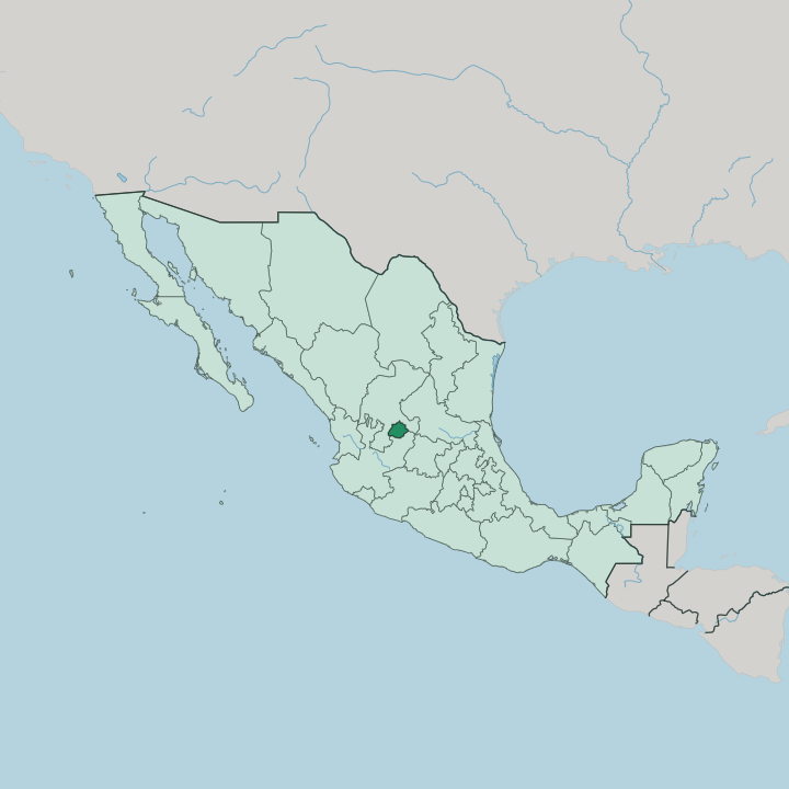


Towns & cities in Estado de Aguascalientes
Pick a town or city — each links to where to stay.
Aguascalientes City is the obvious base for the whole state, and nearly every visitor stays there. The capital holds the fairgrounds, the museums and the airport, all within a short ride of one another. Two towns reward a night away.
Calvillo, in the guava country of the southwest, sits below the Sierra Fría; Real de Asientos, an old silver town in the east, keeps its tunnels and hillside chapels. During the fair the capital books up months ahead, and many visitors sleep in the surrounding towns and drive in.
About Estado de Aguascalientes
What is Estado de Aguascalientes known for?
Estado de Aguascalientes is known above all for the Feria Nacional de San Marcos, the biggest annual fair in Mexico, which fills its capital city each spring. The state gave the country the engraver José Guadalupe Posada, whose skeletal Catrina became an emblem of the Day of the Dead. Aguascalientes is one of Mexico's tiniest states.
For all its small size, it packs vineyards, guava orchards around Calvillo, and the pine forests of the Sierra Fría into one compact plateau. Hot springs gave the place its name.
Where is Estado de Aguascalientes?
Estado de Aguascalientes is one of the smallest states in Mexico, a compact wedge of high plateau in the region called El Bajío. Zacatecas wraps around it on three sides, to the north, east and west, while Jalisco borders it to the south. The land is not flat. The Sierra Fría rises in the west into oak and pine forest, the highest and coldest ground in the state, while the eastern municipalities fall away toward drier, lower basins.
Down the middle runs the valley of the Río San Pedro, also called the Aguascalientes, the artery that drains the whole state southward. That river feeds into the Río Grande de Santiago, part of the great Lerma-Santiago system that carries these highland waters to the Pacific. Around the town of Calvillo, in the southwest, the valleys warm enough for guava orchards and vineyards.
The capital sits near the centre, on the plateau floor. The state splits into eleven municipalities in all, most of them small. Aguascalientes City, the capital, holds the great bulk of the state's people and anchors every route in and out.
The rest is farmland, reservoir and hill.
What is Estado de Aguascalientes like?
Estado de Aguascalientes turns each spring on the Feria Nacional de San Marcos, a month-long fair first held in 1828, centred on the arcaded Jardín de San Marcos in the capital. For weeks it fills with bullfights and cockfights, with charro riders and mariachi bands, and pulls visitors from every state in the country. Spanish runs through all of it.
The state also gave Mexico José Guadalupe Posada, the engraver whose grinning skeletons, above all the elegant Catrina, became the visual language of the Day of the Dead across the country. That figure belongs to all of Mexico, but it was drawn here. Beyond the fair, the state keeps a strong craft and food tradition.
Around Calvillo the guava harvest becomes candied sweets, preserves and liqueurs sold along the roadside, while drawn-thread deshilado embroidery is stitched by hand in the surrounding villages. Vineyards ring the capital, and they turn out wine and brandy. Its kitchens lean on maize and pork.
Come the Day of the Dead, the Festival de Calaveras turns the capital into a parade of painted Catrinas, a direct nod to the man who first drew her.
What is the history of Estado de Aguascalientes?
The Spanish founded the town of Aguascalientes in 1575 on the road between the silver mines of Zacatecas and the capital of New Spain. For most of the colonial centuries it belonged to Zacatecas. That changed in 1835, when Santa Anna set Aguascalientes apart as its own territory after crushing a Zacatecan revolt, and local legend credits a governor's wife with sealing the split.
The constitution of 1857 confirmed it. Later the railway workshops of the Mexican Central line turned the capital into one of the country's great rail towns.
What is the climate of Estado de Aguascalientes?
Estado de Aguascalientes has a dry highland climate, kept mild through the year by its height on the plateau rather than by any coast. Little rain falls across this highland. Most of it comes in heavy afternoon storms between June and September.
The long dry season that follows leaves the eastern flats of the Bajío brown and dusty until the rains return. The Sierra Fría in the west stays cooler and greener, high enough to hold pine and oak where frost bites on winter nights. Sun is the constant.
How do you get to Estado de Aguascalientes?
Getting to Estado de Aguascalientes means flying or driving. The Aguascalientes International Airport, just outside the capital, links the state to Mexico City and to several cities in the United States. Federal Highway 45 runs the length of the state, the old road spine that ties the Bajío to the northern border.
Long-distance buses use the same corridor. The capital has been a working rail junction since the Mexican Central built its locomotive workshops there, back when the line first pushed north through the plateau.
Updated July 2026