Mexico
Estado de Zacatecas, Mexico — Towns & Travel Guide


Zacatecas is Mexico's silver state, its colonial capital a UNESCO city of pink cantera stone under the Cerro de la Bufa on the central plateau.
About Estado de Zacatecas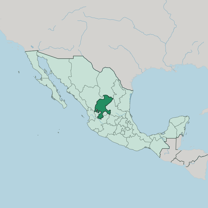


Towns & cities in Estado de Zacatecas
Pick a town or city — each links to where to stay.
Almost everyone starts in the capital. Zacatecas city climbs the walls of a narrow ravine below the Cerro de la Bufa, and its pink-cantera lanes hold the cathedral, the teleférico, and most of the state's good hotels. Guadalupe adjoins it to the east, close enough to share a bus line.
Farther out, Jerez and Fresnillo make quieter bases for the plateau's ranch country and mining towns. Choose the centro for a first visit.
About Estado de Zacatecas
Silver made Zacatecas.
What is Estado de Zacatecas known for?
Spanish prospectors struck a rich lode below the Cerro de la Bufa in 1546, and the ore they pulled from these hills bankrolled the colonial city whose pink-stone centre carries a UNESCO listing. Fresnillo still works one of the largest silver mines on earth. The state is known for more than metal.
Its brass-and-drum tamborazo, the hilltop battlefield where Pancho Villa broke the federal army, and the pre-Hispanic ruins of La Quemada all draw travellers onto the plateau.
Where is Estado de Zacatecas?
The state has no coast. It spreads across the high tableland of the Mexican Plateau, a tenth-largest state whose ground rarely drops below the height of the passes that ring it, tilting from the Sierra Madre Occidental down toward the eastern plains. Three landscapes divide it.
The Sierra Madre Occidental walls the west and southwest in pine-dark ridges; the Meseta Central rolls across the centre and north in dry rangeland; and a spur of the Sierra Madre Oriental crumples the far north. Between them run the silver hills, chief among them the Sierra de Fresnillo. The capital itself sits over two kilometres up, cool air thinning over its rooftops.
Eight states press in around it. Durango lies to the west and Coahuila to the north, Nuevo León touches a corner in the northeast, and San Luis Potosí runs down the east. Guanajuato meets it in the southeast. Jalisco, small Aguascalientes and Nayarit close the south and southwest, Aguascalientes all but wrapped inside Zacatecan territory.
No sea reaches any of its edges. Rivers here are seasonal, cutting canyons like the Juchipila and the Aguanaval before draining west to the Pacific watershed or east into the closed basins of the plateau. Water is scarce; silver never was.
What is Estado de Zacatecas like?
Zacatecas wears its silver money in stone. Mine owners poured their fortunes into churches and mansions of rose-pink cantera, and the Baroque façades of the capital's cathedral still count among the most worked in Mexico. The music is louder than the stone.
On weekend nights a tamborazo band of clarinets, drums and brass leads a callejoneada through the lanes, a walking party trailing a donkey loaded with mezcal. Both were born on this plateau. Its writers and painters left as strong a mark.
The poet Ramón López Velarde grew up in Jerez, and the painter Francisco Goitia came from Fresnillo, both names carried by the capital's museums beside the Coronel brothers' collections of masks and old masters. Older layers show through too. The Chichimeca frontier ran through here, and the stone terraces of La Quemada climb a hill south of the capital, raised long before any Spaniard saw the silver.
Each August the Morismas de Bracho stage a mock battle of Moors and Christians on the capital's edge, thousands in costume wheeling across the hillside. Faith, ranch life and mezcal fill the rest.
What is the history of Estado de Zacatecas?
Silver wrote the whole story. Chichimeca peoples held this plateau until 1546, when Juan de Tolosa's strike below the Cerro de la Bufa turned it into one of the richest silver camps of the Spanish empire. The Camino Real carried its bullion south to Mexico City.
Zacatecas became a state in 1823. Its militia was broken by Santa Anna in 1835, and eight decades later Pancho Villa stormed the Cerro de la Bufa in the bloody Toma de Zacatecas that helped topple the old regime.
What is the climate of Estado de Zacatecas?
Two kilometres up, it is Zacatecas's height that fixes its weather. Two kilometres up, Zacatecas keeps a cool semi-arid climate, its days bright and dry through most of the year and its nights cold enough for winter frost on the plateau. Rain comes in one short burst.
Summer afternoons bring thunderstorms off the sierras from July into September, greening the rangeland for a few weeks before the dry months return. West in the Sierra Madre Occidental the air turns wetter, cooler and thick with pine.
How do you get to Estado de Zacatecas?
The plateau is a long way from any coast. Zacatecas has its own international airport out at Morelos, north of the city, with flights from Mexico City, Guadalajara and Tijuana and cross-border runs from Los Angeles, Houston and Chicago. Many arrive overland instead.
The old Camino Real, now Highway 45, threads north from Aguascalientes through the capital and Fresnillo toward Durango, and buses run it all day. A second way in is the airport at Aguascalientes.
Updated July 2026