Mexico
Estado de Campeche, Mexico — Towns & Travel Guide


Estado de Campeche spreads across the western Yucatán Peninsula, a walled Gulf capital backed by the Maya forests of Calakmul.
About Estado de Campeche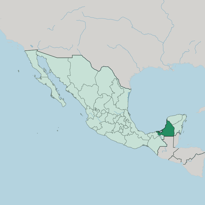


Towns & cities in Estado de Campeche
Pick a town or city — each links to where to stay.
Most trips start in the capital. San Francisco de Campeche packs its hotels inside the old ramparts, an easy walk from the sea gate, Calle 59 and the malecón along the Gulf. Ciudad del Carmen, out on Isla del Carmen, guards the mouth of Laguna de Términos.
For the ruins, base yourself at Xpujil, the last real town before Calakmul. Choose the walled centre for a first visit; head south only if Calakmul's forest is the point.
About Estado de Campeche
Pirates and the Maya define it.
What is Estado de Campeche known for?
San Francisco de Campeche, the walled capital, still carries the ramparts and eight bastions Spain raised against buccaneers, and its grid of pastel houses earned the state a UNESCO listing. Deep in the southern forest stands Calakmul, the old seat of the Kaan dynasty and a rival of Tikal. Nearer the coast, Edzná raises its Temple of the Five Stories.
Its cooks are known for pan de cazón, tortillas layered with shredded dogfish under tomato and habanero.
Where is Estado de Campeche?
Campeche fills the western side of the Yucatán Peninsula, in southeastern Mexico. Its whole western edge is the Gulf of Mexico, curving along the Bay of Campeche. Inland it lies mostly flat, a low shelf of limestone that drinks the rain rather than shedding it.
The land tilts gently. Low Puuc hills roll across the drier north, honeycombed with caves and sinkholes that hold the groundwater, while rivers and wetter forest take over toward the humid south. Tabasco borders it to the southwest, Yucatán to the northeast, and Quintana Roo along the east. The southern boundary runs up against Guatemala, and the far southeastern corner brushes Belize.
Water shapes the south. The great Laguna de Términos, the largest tidal lagoon lying wholly on the Gulf of Mexico, spreads behind Isla del Carmen, fed by the Candelaria and other rivers draining out of the forest. Ciudad del Carmen sits on that island, at the lagoon's Gulf-facing mouth.
Farther south the ground rises into unbroken tropical forest, where Calakmul's biosphere reserve stretches to the Guatemalan line. Few roads cross it. The capital stands on the coast, roughly midway along that Gulf shore.
What is Estado de Campeche like?
Campeche keeps a slow pace. The walled capital fills its historic centre with houses painted ochre, indigo and rose, laid on a grid the Spanish drew after pirates burned the port more than once. Evenings fill the plaza and the malecón, not the nightclub strips of the Riviera Maya.
Two stone forts, San Miguel and San José, look down on the city from the hills. That quiet is the draw. Music, dances like the jarana, and the traditional white dress of the region carry a Yucatecan culture shared with the peninsula next door.
The Maya never left. Yucatec Maya is still spoken in villages across the state, and the old cities, Calakmul deep in the forest, Edzná near the coast, stand as their monuments. The kitchen mixes Maya, Spanish and Gulf traditions in equal measure.
Pan de cazón layers tortillas with shredded dogfish, black beans and habanero; cochinita pibil roasts pork in achiote and sour orange in a buried pib. Shrimp comes fried in coconut. Spanish is the everyday language, layered over Maya roots that surface in place names and food alike.
Out on the coast, Ciudad del Carmen runs to a different rhythm, a working oil-and-shrimp port rather than a colonial showpiece.
What is the history of Estado de Campeche?
The Maya came first. Calakmul rose in the southern forest to lead the Kaan dynasty, one of the two great powers of the Classic Maya world, before its cities were left to the jungle. Spanish forces under Francisco de Montejo founded the port of Campeche in 1540, on the Maya town of Can Pech.
Its wealth came from logwood, the dyewood shipped to Europe, and that wealth drew pirates who sacked the town repeatedly. So Spain walled it. Campeche broke from Yucatán to become a state of its own in 1858.
What is the climate of Estado de Campeche?
Campeche runs hot all year. A tropical wet-and-dry rhythm splits the calendar: heavy rains sweep in from about June to October, then a drier spell settles over the state from November into April. The northern Puuc country stays drier than the rainforest in the south.
Late summer brings the risk of hurricanes off the Gulf of Mexico. Sea breezes soften the coast.
How do you get to Estado de Campeche?
The capital has its own airport. Alberto Acuña Ongay International, at San Francisco de Campeche, and a second airport at Ciudad del Carmen handle domestic flights, though many travellers land first at Mérida or Cancún and drive down. Highway 180 traces the Gulf coast from Yucatán down through the capital.
The Tren Maya railway crosses the state, stopping at Campeche and the junction town of Escárcega. Buses run everywhere else.
Good for
Updated July 2026