Mexico
Estado de Tabasco, Mexico — Towns & Travel Guide


Tabasco is Mexico's wet Gulf lowland, drained by the Grijalva and Usumacinta rivers and holding the Olmec ruins of La Venta near Villahermosa.
About Estado de Tabasco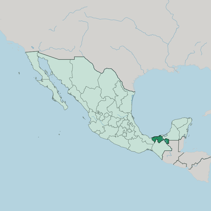


Towns & cities in Estado de Tabasco
Pick a town or city — each links to where to stay.
Villahermosa is the natural base. The state capital sits on the Grijalva River with the airport, nearly all the hotels, and the open-air Parque-Museo La Venta holding the Olmec colossal heads. West toward the Grijalva delta lie Comalcalco's fired-brick Maya ruins and the cacao haciendas along the Ruta del Cacao.
North on the Gulf of Mexico, Paraíso lines oyster bars along the Mecoacán lagoon. Tenosique guards the far southeast, the launch point up the Usumacinta River toward the Guatemala border. Base in Villahermosa first; ride out for cacao country or the coast.
About Estado de Tabasco
The Olmec and cacao define Tabasco.
What is Estado de Tabasco known for?
La Venta, the great Olmec city near the Gulf coast, left colossal basalt heads that stand in the open-air Parque-Museo La Venta in Villahermosa. The land between the Grijalva and Usumacinta rivers has yielded cacao since Maya times, and the fired-brick Maya city of Comalcalco anchors a route of working chocolate haciendas. Tabasco also pumps much of Mexico's oil.
Its cooks prize pejelagarto, a long-snouted river gar roasted whole.
Where is Estado de Tabasco?
Tabasco lies in the southeast of Mexico, a flat wedge of Gulf coast between the highlands of Chiapas and the sea. Veracruz borders it to the west. Chiapas rises along the south, Campeche closes the northeast, and the Usumacinta River traces part of the frontier with Guatemala to the southeast. To the north is open water, the Gulf of Mexico, along a low coast of sandbars, lagoons, and river mouths.
Most of the state is the Tabasco Plain. The Grijalva and Usumacinta rivers built it, carrying silt down from the mountains of Chiapas and Guatemala across the whole delta. These are two of the largest rivers in Mexico, and they braid together near the coast before spilling into the Gulf.
Their floods spread across the low delta every wet season. Those two rivers have long been the roads here, avenues the Chontal Maya and every trader since have followed inland from the sea. The result is a land of swamp, marsh, and shallow lagoon, and the Pantanos de Centla protect the greatest of these wetlands at the rivers' mouth.
Only in the south does the ground climb, toward the first ridges of the Sierra as Chiapas begins. Little of it stands far above the water.
What is Estado de Tabasco like?
Tabasco carries the deepest roots in Mexico. The Olmec, the mother culture of Mesoamerica, raised La Venta on the coastal plain and carved the colossal basalt heads that Carlos Pellicer, the Tabascan poet, later gathered into the Parque-Museo La Venta at Villahermosa. Then came the Maya.
Their city at Comalcalco survives, and their descendants, the Chontal or Yokot'an, farm and fish the delta and speak their own tongue beside Spanish. No other Maya capital rose in fired brick and oyster-shell lime, for the delta has no stone. Cacao is the other thread.
The Maya drank it and counted wealth in its beans, and Tabasco has raised it ever since, shaded under the fruit trees of the haciendas around Comalcalco. That heritage flavours the table. Cooks pour pozol, a cold drink of ground maize and cacao, and roast pejelagarto, the long-snouted gar pulled from the rivers, and fold chocolate and ripe plantain into everyday food.
Villahermosa marks the harvest with its own chocolate festival. Rain and river set the pace, and life bends toward the water in a way no highland town in Mexico quite shares.
What is the history of Estado de Tabasco?
The Olmec were here first. They built La Venta near the coast, a great Olmec city of Mesoamerica that rose to prominence around 900 BC, and the Maya later raised the brick temples of Comalcalco. The Spanish also landed here before almost anywhere on the mainland.
Hernán Cortés beat the Chontal Maya at the Battle of Centla in 1519 and was given La Malinche, the woman who would interpret his conquest. Villahermosa rose on the Grijalva in 1564. Tabasco joined the Mexican federation in 1824, and oil later remade it.
What is the climate of Estado de Tabasco?
Tabasco is the wettest state in Mexico. Heat and humidity hold all year, with no cool season to speak of on the low delta. Rain falls in every month but turns torrential from June into November, when Gulf storms and the moisture wrung out against the Chiapas highlands pour onto the plain.
The rivers rise, and whole districts of the delta flood, as Villahermosa learned when the Grijalva drowned much of the city in 2007. A short drier spell comes before the summer rains. It never really cools.
How do you get to Estado de Tabasco?
Villahermosa is the way in. Its Carlos Rovirosa Pérez airport handles the state's flights, linking the capital to Mexico City and the Gulf coast. By road, the coastal highway arrives from Veracruz in the west and from Campeche and the Yucatán in the east, and ADO buses run both ways.
From the south, the highway drops out of the Chiapas hills past Palenque, whose Maya ruins pair naturally with a stop in Tabasco. Rivers carried all of this once, the Grijalva and Usumacinta hauling it by boat. The road took over.
Updated July 2026