Mexico
Estado de Sonora, Mexico — Towns & Travel Guide


Sonora is a desert state in northwestern Mexico, its Sonoran Desert stretching west to the beaches of the Gulf of California.
About Estado de Sonora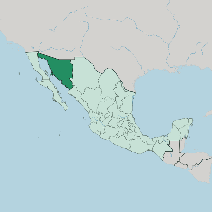


Towns & cities in Estado de Sonora
Pick a town or city — each links to where to stay.
Most trips to Sonora are beach trips, and the coast holds the resorts. Puerto Peñasco draws the biggest crowds. The town Arizonans know as Rocky Point sits on the Gulf of California, a short drive south of the border crossing at Lukeville.
San Carlos is the quieter rival, its marina and dive boats gathered below the twin-horned peak of Cerro Tetakawi. Bahía de Kino slows the pace again. Its long beach looks across a narrow channel to Isla Tiburón, the Seri homeland, while Hermosillo inland serves as a city base and a stop on the drive south.
About Estado de Sonora
What is Estado de Sonora known for?
Sonora is Mexico's second-largest state, a wide expanse of desert, ranchland, and Gulf coast in the country's northwest. Beaches draw most visitors. Puerto Peñasco, the resort town Arizonans call Rocky Point, sits on the Gulf of California within a few hours' drive of the United States border.
Hermosillo, the capital, anchors the centre. Inland, the Sonoran Desert gives way to the volcanic craters and black lava of the El Pinacate y Gran Desierto de Altar Biosphere Reserve. Carne asada, grilled over mesquite, is the food everyone knows it for.
Where is Estado de Sonora?
Sonora fills the northwest corner of mainland Mexico, second in size only to Chihuahua next door. Its northern edge is the United States border. Arizona lies directly across that line, with a short stretch of New Mexico at the northeastern corner.
Chihuahua rises to the east behind the mountains, Sinaloa continues the coast to the south, and the Gulf of California separates Sonora from the peninsula of Baja California to the west. The state runs from mountains to sea. Three landscapes divide the state.
The Sierra Madre Occidental walls off the east in pine-clad ridges and deep barrancas, catching the rain that the lowlands never see. Rolling plains fill the centre. The west is the Sonoran Desert, and its most barren reach, the Gran Desierto de Altar, throws up a sea of active dunes and the cinder cones of the Pinacate lava field near the Colorado River delta.
Rivers born in the sierra cross the plains to the coast. The Yaqui River and the Sonora River water the wheat valleys before spilling into the Gulf of California, and the Mayo does the same in the south. The coast runs long and dry.
From the Colorado delta in the northwest down to the Sinaloa border, Sonora's Gulf shoreline strings together wide beaches, tidal estuaries, and rocky islands like Tiburón.
What is Estado de Sonora like?
Sonora is ranch country with deep indigenous roots. The Yaqui people hold eight river towns along the lower Río Yaqui, where the deer dance, the danza del venado, is still performed each Easter. Seri families live on the desert coast facing Isla Tiburón, carving sea creatures from dense ironwood.
Mayo farmers work the southern valleys. The Spanish missions of the seventeenth century reshaped nearly all of it. Their languages are still spoken.
Cattle define the table. The Jesuit Eusebio Kino drove the first herds and wheat north into these valleys in the late seventeenth century, and the vaquero ranch culture that grew from them still sets the tone. Beef over mesquite is the point.
Carne asada, chopped fine and folded into a wheat-flour tortilla the size of a plate, is the Sonoran plate, served with machaca, frijoles puercos, and a salsa of wild chiltepín. Flour tortillas, not corn, rule here. Bacanora, an agave spirit banned for much of the twentieth century, is distilled in the eastern sierra town that gave it its name.
The result feels more like the American West than central Mexico.
What is the history of Estado de Sonora?
People farmed the Río Yaqui and Río Mayo valleys long before Spain arrived. Jesuit missionaries, led by Eusebio Kino, pushed north into the Pimería Alta in the late seventeenth century, bringing cattle, wheat, and the mission towns that seeded the modern cities. Statehood came slowly.
Sonora and Sinaloa were governed together through the colonial period and briefly shared the Estado de Occidente, splitting into a separate state of Sonora in 1831. The Yaqui resisted for two centuries more.
What is the climate of Estado de Sonora?
Sonora is hot and dry for most of the year. Summer bakes the Sonoran Desert. The North American monsoon, known here as las aguas, breaks the heat from July into September with sudden afternoon thunderstorms that green the desert and fill the arroyos.
Winters are mild on the coast and cold in the high Sierra Madre Occidental, where the highlands around Cananea can see winter snow. Rain is the exception, not the rule.
How do you get to Estado de Sonora?
Most visitors arrive from Arizona. The busiest crossing is at Nogales, where Federal Highway 15 runs south past Hermosillo and Ciudad Obregón toward Sinaloa. Hermosillo's General Ignacio Pesqueira García International Airport takes the domestic flights, with connections through Mexico City, Tijuana, and Guadalajara, plus a few links to Phoenix and Los Angeles.
Puerto Peñasco has its own road. Beach traffic from Arizona reaches it through the small border post at Sonoyta, the shortest desert run to the Gulf of California.
Good for
Updated July 2026