Peru
Departamento de Amazonas, Peru — Towns & Travel Guide


Amazonas is northern Peru's cloud-forest department, where the Utcubamba carves past Kuélap and the Gocta waterfall drops from the mist.
About Departamento de Amazonas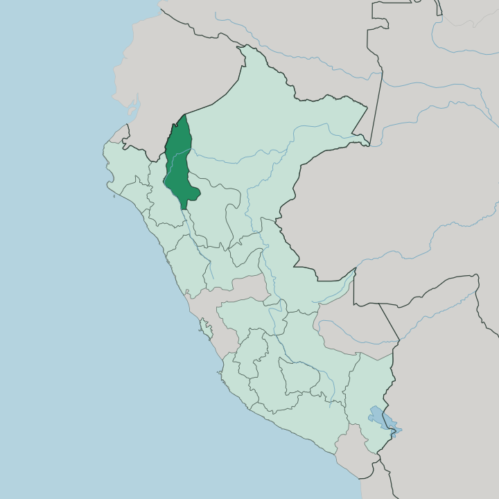
Towns & cities in Departamento de Amazonas
Pick a town or city — each links to where to stay.
Chachapoyas is the base for most of the department. The old Spanish town sits high above the Utcubamba, a short drive from Kuélap and the tombs, and its plaza and wooden-balconied streets hold the region's widest choice of beds. Cocachimba is the other choice, a hamlet on the rim of the Gocta gorge where lodges look across at the falling water.
The third option is lower down. Bagua Grande, on the warm valley floor, is a transit town rather than a sight in itself. Pick Chachapoyas to reach the ruins; pick Cocachimba to wake up in front of the waterfall.
About Departamento de Amazonas
Amazonas is Chachapoya country.
What is Departamento de Amazonas known for?
Long before the Inca reached it, the people the Spanish called warriors of the clouds built the ridge fortress of Kuélap, more than four hundred round stone houses ringed by a wall on a limestone crest above the Utcubamba River. The waterfall at Gocta, one of the tallest in the world, plunges from the montane forest nearby. Cliff tombs and sarcophagi hang on the canyon walls further south.
This is Peru's north seen from the clouds.
Where is Departamento de Amazonas?
Amazonas fills a band of northern Peru where the eastern Andes break down into the upper Amazon basin. Ecuador lies along its northern and north-western edge, and the Cordillera del Cóndor draws that international line across a range whose ownership Peru and Ecuador fought over for most of a century. Cajamarca borders it to the west, La Libertad to the south, and San Martín and Loreto to the east. The land tilts hard.
The Marañón River cuts a deep north-flowing trench down the western side of the department, and the Utcubamba, its tributary, runs the length of the interior and gives the region its real axis. Most of the department is forest. The lower ground toward Loreto is true rainforest, hot and green, while the higher country around the capital is cloud forest, a wet montane belt where the trees stand in near-permanent haze.
Between the two, the Utcubamba has carved a canyon that drops well over a thousand metres from rim to river. Chachapoyas, the capital, sits high on that terrain at around 2,335 metres. Down on the valley floors the air turns warm and thick.
This vertical range, from steaming lowland to misted ridge in a single department, is what shapes everything here.
What is Departamento de Amazonas like?
The Chachapoya legacy runs through everything the department shows a visitor. This was the heartland of the people the Spanish named warriors of the clouds, a mountain culture that raised Kuélap and the cliff tombs of the Utcubamba valley, and their stonework still defines the landscape a traveller comes to see. Spanish is the common tongue now, spoken by the great majority, though the department carries the deeper Quechua and Chachapoya past in its place names and its ruins.
Chachapoyas, the capital, is the oldest Spanish town east of the Peruvian Andes, and its plaza, whitewashed walls and carved wooden balconies still hold the shape of a colonial highland settlement. Culture here is a layered thing. It is the sarcophagi of Karajía standing on a ledge, the round houses of Kuélap on their ridge, the mummies gathered from the Laguna de los Cóndores and now kept at the Leymebamba museum.
It is coffee grown on the valley slopes and the mist that gives the region its name. Away from the ruins, life is quiet and rural, worked out on steep ground between the forest and the river.
What is the history of Departamento de Amazonas?
The Chachapoya built here first. From around the year 800 they raised Kuélap and their cliff tombs across the Utcubamba country, and they held that ground until the Inca ruler Túpac Yupanqui broke their resistance in the 1470s. Spanish rule followed within a lifetime: Alonso de Alvarado founded the town of Chachapoyas in 1538, the earliest Spanish settlement east of the Peruvian Andes.
The department of Amazonas itself was created in 1832, once Peru was a republic. Its story is read off the ridges, in stone laid long before either conquest.
What is the climate of Departamento de Amazonas?
Altitude, not season, sets the weather here. Around Chachapoyas the cloud forest stays cool and wet, the ridges wrapped in the haze that gave the Chachapoya their name, and rain can fall in any month. Drop into the Utcubamba canyon or down toward Bagua Grande and the air turns hot and heavy, closer to the rainforest that fills the eastern edge of the department.
A drier stretch runs from roughly May to September. That window is when most travellers walk up to Kuélap and out to the Gocta falls.
How do you get to Departamento de Amazonas?
Getting here takes effort. The usual approach is by air to the Jaén airport in neighbouring Cajamarca, then a road transfer of several hours east along the Utcubamba valley up to Chachapoyas. Long-distance buses also grind in from the Peruvian coast and from Lima, climbing over the Andes into the region.
After that, everything runs on winding mountain roads. A cable car lifts visitors the last stretch up to Kuélap on its ridge, high above the valley floor where the Chachapoya once held the high ground.
Good for
Updated July 2026