Thailand
Changwat Kamphaeng Phet, Thailand — Towns & Travel Guide


Kamphaeng Phet is a province of central Thailand on the Ping River, where a walled Sukhothai garrison town left its ruins in laterite stone.
About Changwat Kamphaeng Phet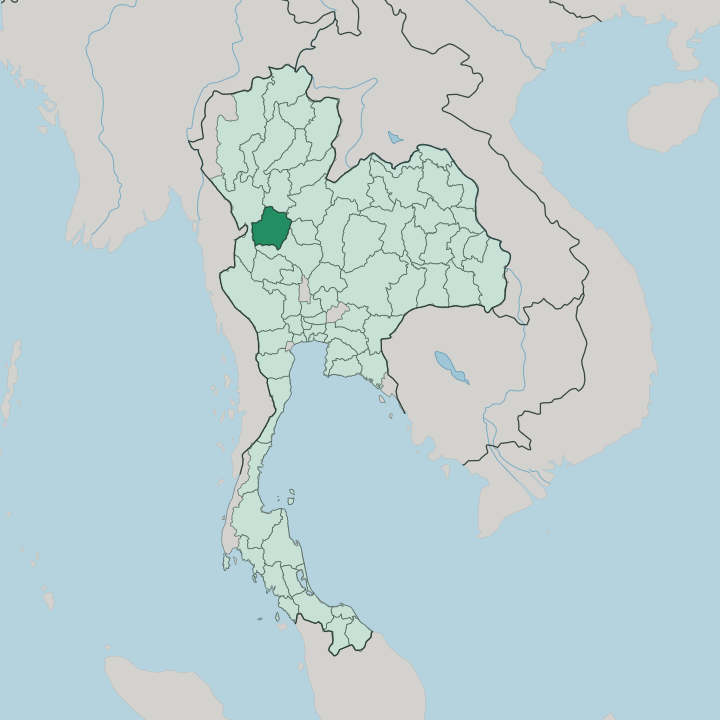


Towns & cities in Changwat Kamphaeng Phet
Pick a town or city — each links to where to stay.
Almost everyone stays in the town of Kamphaeng Phet, on the east bank of the Ping River within a short ride of the walled old city. Riverfront hotels cluster near the night market, close enough to reach the ruins by bicycle at dawn. Across the water sits Nakhon Chum, the quieter sister settlement, where the gilded chedi of Wat Phra Borommathat still draws pilgrims.
Choose the town for the temples. Head west toward Khlong Lan National Park and the Dawna Range only if you want waterfalls, forest trails and a night under the trees rather than a night among stone.
About Changwat Kamphaeng Phet
The name means a wall as hard as diamond.
What is Changwat Kamphaeng Phet known for?
Kamphaeng Phet Historical Park is the reason most travellers stop, a walled old city of laterite temples that joined the ruins of Sukhothai on the UNESCO World Heritage list in 1991. Beyond the moat lies the Aranyik zone, a forest-monk quarter where Wat Chang Rop still stands on a base of stucco elephants and Wat Phra Si Iriyabot keeps its tall standing Buddha. The western half is another world.
There the Dawna Range rises into the rainforests of Khlong Lan National Park, and the small sweet kluai khai banana grows on the plains below.
Where is Changwat Kamphaeng Phet?
Kamphaeng Phet sits in central Thailand, on the Ping River about midway on the old road between Bangkok and Chiang Mai. The Ping is a main tributary of the Chao Phraya River, and its valley cuts the province cleanly in two. East of the river lie the flats.
These are the alluvial plains where the rice and banana farms spread out and where the towns were built. West of the river the land climbs. It rises into the Dawna Range, a forested chain of hills reaching toward the Myanmar frontier, and roughly a quarter of the whole province still lies under forest cover.
Tak wraps around the western and north-western edge, Sukhothai lies to the north, and Phitsanulok touches the north-east. Phichit borders it on the east and Nakhon Sawan closes the province off to the south, downstream toward the Chao Phraya. It is the fourth-largest province of central Thailand.
Three national parks guard the western uplands. Mae Wong and Khlong Lan protect rainforest, waterfalls and tiger habitat along the Dawna watershed, while Khlong Wang Chao covers the rugged ground between them.
What is Changwat Kamphaeng Phet like?
Kamphaeng Phet keeps a slow, agricultural rhythm that few foreign tourists interrupt. Its emblem is the kluai khai, a small egg-shaped banana so tied to the place that a ten-day Banana Festival fills the streets each September with parades and sticky-sweet tastings. Faith runs through the calendar too.
The Nop Phra Len Phleng fair, held between February and March, recalls a donation of Buddha relics made in the year 1357, and it pairs solemn processions with a country fair. The Buddhist inheritance here is old. It reaches back to the Sukhothai Kingdom, whose sculptors gave the standing and walking Buddhas their long, serene faces, and whose forest-dwelling monks built the aranyik hermitages out in the woods.
Laterite is the local stone. The blood-red blocks quarried nearby give the ruins and many older temples their weathered colour. Out west, the picture changes again.
Around Khlong Lan National Park, Hmong and Karen hill communities keep their own languages and market days, a different Thailand from the rice plains. When the moon is full in the twelfth lunar month, candlelit krathong floats drift down the Ping River past the old walls.
What is the history of Changwat Kamphaeng Phet?
The old town began as Chakangrao, a garrison on the Ping River raised under the Sukhothai Kingdom in the 14th century. Its job was war. Thick laterite ramparts and a broad moat turned it into a forward shield, first for Sukhothai and then for the Ayutthaya Kingdom that absorbed it, holding the line against Burmese armies pushing down from the west.
The walls earned the town its later name, kamphaeng phet, a wall as hard as diamond. When the old capitals fell and the frontier moved, the garrison lost its purpose and the forest closed over the temples. The ruined old town joined the UNESCO World Heritage list in 1991 as Kamphaeng Phet Historical Park.
What is the climate of Changwat Kamphaeng Phet?
The province has a tropical savanna climate, warm in every month of the year. Three seasons take turns. A hot, dry spell builds from March, when the plains bake and the Ping shrinks between its banks.
Then the south-west monsoon breaks in around May and pours most of the year's rain onto the Dawna Range and the fields below it until October. The cool season that follows, from November into February, is the one to travel in: clear skies, warm days and comfortable nights over the ruins. Rain, when it comes, is heaviest in the western hills.
How do you get to Changwat Kamphaeng Phet?
No airport, no railway. Most travellers reach Kamphaeng Phet on Highway 1, the Phahonyothin road that Asian Highway 1 follows south out of Chiang Mai and north out of Bangkok before the traffic ever crosses a provincial line. Buses leave all day from Bangkok's Mo Chit terminal and take five to six hours.
The nearest airports and railhead sit at Phitsanulok, off to the north-east, with a smaller airfield at Sukhothai. From Sukhothai's ruins it is a short hop south. In town, a rented bicycle beats a car for the walled old city and the riverside lanes.
Good for
Updated July 2026