Thailand
Changwat Phetchaburi, Thailand — Towns & Travel Guide


Phetchaburi is a province of western Thailand, reaching from the Tenasserim Hills to the upper Gulf of Thailand around an old royal temple town.
About Changwat Phetchaburi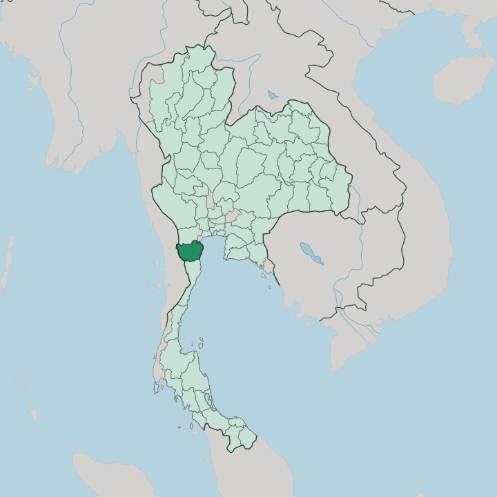


Towns & cities in Changwat Phetchaburi
Pick a town or city — each links to where to stay.
Most first-timers split their nights between the coast and the old town. Cha-am is the beach. Its long, shallow strand fills with Bangkok families at weekends, and the teak pavilions of Mrigadayavan Palace stand a little way down the sand.
Inland, Phetchaburi town sits under Khao Wang among the Khmer prangs, close to the markets and the palm-sugar kitchens. Out west, forest lodges ring Kaeng Krachan, while birdwatchers head for the salt pans at Pak Thale. Start with Cha-am or the town.
About Changwat Phetchaburi
Two things pull travellers off the highway here.
What is Changwat Phetchaburi known for?
The first is the old town. King Mongkut set a palace, temples and an observatory across three hilltops at Phra Nakhon Khiri, above a river town of Khmer prangs and Ayutthaya shrines where plaster carvers still work by hand. The second is the wild west.
Kaeng Krachan National Park, the largest in Thailand, spills down the Tenasserim Hills, while the Gulf shore runs to salt pans, mangroves and the beach at Cha-am. The palm-sugar sweets are famous too.
Where is Changwat Phetchaburi?
Phetchaburi lies in western Thailand, at the head of the long Malay Peninsula where the mainland narrows toward the south. The whole province tilts eastward. Its back is the Tenasserim Hills, the forested range that carries the border with Myanmar along its crest, and from that high western wall the land falls away through foothills and paddy to the shallow upper Gulf of Thailand.
Kaeng Krachan National Park fills the mountain half, the largest national park in the country, rainforest cloaking the eastern slope of the range. Ratchaburi adjoins it to the north and Prachuap Khiri Khan to the south. One river ties it all together. The Phetchaburi River rises in the Tenasserim Hills inside the park, where a dam holds it back as a broad reservoir, then runs east for the length of the province past Tha Yang, Ban Lat and the old capital before reaching the sea at Ban Laem.
Along that coast the shore is not sand but salt: pans, tidal mudflats and mangrove line the Gulf at Pak Thale, a roost for tens of thousands of migrating shorebirds. The one true beach is Cha-am, down toward the Prachuap Khiri Khan side. Bangkok lies only a couple of hours northeast by road, close enough to draw weekend crowds down to the sand.
The south begins here.
What is Changwat Phetchaburi like?
Phetchaburi wears its royal past as craft. For centuries its craftsmen were the plasterers, gilders and woodcarvers summoned to build temples and palaces across Siam, and their stucco still covers the local shrines. Wat Kamphaeng Laeng keeps its Khmer laterite towers from the days when this was the empire's southern edge, and the sermon hall of Wat Yai Suwannaram carries Ayutthaya-era murals under a teak roof.
Temple fairs fill the old town through the cool months. The most watched night of the year lights the whole of Khao Wang with candles. Then there is the sugar.
Rows of tan palms rise from the paddy around Ban Lat, and farmers still climb them for the sweet sap that is boiled down into the province's amber palm sugar. That sugar makes the sweets Phetchaburi is known for across Thailand, above all khanom mo kaeng, a dense baked custard of mung bean and coconut. The kitchens earned the town a UNESCO listing for gastronomy.
Out on the coast the flavour turns to salt instead, raked in white pyramids from the seawater pans of Ban Laem and Pak Thale. Everyday life here is Thai and Buddhist, ordered by the temple, the market and the river.
What is the history of Changwat Phetchaburi?
The town is old. It began as a Dvaravati trading port on the sea route between India and China, faded when that world declined, then rose again under the Khmer Empire in the twelfth century, whose laterite prangs still stand in the centre. Absorbed into the Ayutthaya kingdom, it guarded the Siamese heartland's southern flank for four hundred years.
Later kings came for the air, not the walls: Mongkut raised his hilltop palace at Phra Nakhon Khiri in 1860, and Vajiravudh built the teak Mrigadayavan Palace by the sea.
What is the climate of Changwat Phetchaburi?
Three seasons run here, not four. The hot months build from March, when the lowland air around the capital turns thick and still. Then the southwest monsoon breaks, and from about May into October the rain climbs hardest against the Tenasserim Hills, filling the Phetchaburi River and greening Kaeng Krachan.
The mountains take the brunt, so the coast at Cha-am stays drier than Thailand's other shore. Come in the cool, dry window from November to February. The nights turn kind then.
How do you get to Changwat Phetchaburi?
Most travellers come down from Bangkok, a bit over two hours to the northeast. The southern railway threads through the province on its way to the Malay Peninsula, and trains stop at both Phetchaburi town and Cha-am; buses and minivans run the same route all day. There is no airport of any size, so flyers use Bangkok or the small field down at Hua Hin.
From the provincial capital, one road climbs west into Kaeng Krachan while the highway carries on south. The rest is easy.
Good for
Updated July 2026