Uzbekistan
Tashkent Region, Uzbekistan — Towns & Travel Guide


Tashkent Region wraps around Uzbekistan's capital, running from the Syr Darya plains up into the Tian Shan.
Find your area →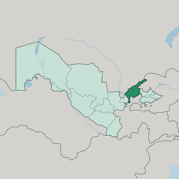
Towns & cities in Tashkent Region
Pick a town or city — each links to where to stay.
The capital city is the natural base. Enclosed inside the region and holding almost all of its beds, Tashkent puts you within an easy drive of everything the province offers, from the mountain lodges in the east to the farmland in the west. East lie the mountains, where cottages sit below Greater Chimgan and along the Charvak reservoir for skiers and hikers.
West and south spread the Syr Darya farmland and the factory towns of the Chirchiq belt, thin on hotels. Stay in the capital and drive out.
About Tashkent Region
What is Tashkent Region known for?
Tashkent Region rings the capital city on every side, an administrative province that completely encircles Tashkent yet stays separate from it. It is a land of two halves. The western part is flat, irrigated farmland along the Syr Darya, while the eastern part climbs fast into the Chatkal and Ugam ridges of the western Tian Shan, where Greater Chimgan tops out above the treeline.
Between them run the industrial towns along the Chirchiq. Cotton and orchards feed the plains; coal, copper, and cement built the cities; the mountains draw skiers in winter and hikers in summer.
Where is Tashkent Region?
Tashkent Region lies in the northeastern corner of Uzbekistan, tilted from the Syr Darya river in the west up to the crest of the Tian Shan in the east. It is a ring. The province wraps entirely around the capital, which is a separate region in its own right, so Tashkent city sits as an enclave inside it, encircled on every side by provincial land.
Along the north and east it borders Kazakhstan, Kyrgyzstan, and Tajikistan, with the mountain ranges marking the frontier. Two halves make up the land. Its western part is low irrigated plain, dropping to around two hundred metres near the Syr Darya, worked for cotton and orchards.
Eastward the ground rises hard into the Chatkal and Ugam ridges of the western Tian Shan, and Greater Chimgan reaches 3,309 metres above the treeline. Draining that high ground is the Chirchiq river, which gathers the meltwater of the Chatkal and Pskem and runs down to join the Syr Darya, the great river of Central Asia that flows on toward the Aral Sea. Behind a rockfill dam on the Chirchiq sits the Charvak reservoir, the largest lake in the country, held in a bowl of the mountains.
Water shapes everything. Green comes to the plains only because the rivers are bled into canals across them.
What is Tashkent Region like?
Life in Tashkent Region orbits the capital. The city is the cultural centre of the whole country, and the province around it lives in that gravity, its towns feeding workers and produce into Tashkent and taking the capital's habits back out. The old identity of the land runs deeper than the modern border.
This was Chach, an ancient oasis watered by the Chirchiq, a caravan stop on the branch of the Silk Road that ran north toward the steppe. Uzbek is the common tongue, though Russian is still widely spoken in the industrial towns from the Soviet decades that built them. Faith, food, and the rhythm of the bazaar sit at the centre of daily life.
Bread comes from the tandyr, plov from the cauldron, fruit from the orchards that fill the plains each summer. The mountains carry their own culture apart from the plains. In the villages below Chimgan, herders still take flocks up to the high pastures when the snow clears, and weekend crowds from the capital come the other way, up from the city to the cool air and the reservoir.
That pull between plain and peak, between the industrial towns and the farm villages, gives the region its texture. It is neither the capital nor the mountains alone. It is the belt of country that holds both together.
What is the history of Tashkent Region?
The land was old long before the province was drawn. In antiquity this was the Chach oasis, a cluster of walled settlements on the Chirchiq that traded along the Silk Road and passed through the Karakhanids and the empire of Timur. Caravans crossed here.
The modern region is a Soviet creation, established in 1938 as a viloyat around the capital, and in those decades the plains were turned over to cotton while the mountain rivers were harnessed for coal and metal. Angren rose in 1946 on the coal basin to the east. Nurafshon, once the town of Toʻytepa, was named the regional capital only later.
What is the climate of Tashkent Region?
The region runs hot and dry in summer and cool in winter, a sharply continental climate far from any sea. On the Syr Darya plains the summer sun is fierce and rain is scarce, so the crops live on irrigation rather than weather. The mountains rewrite the rules.
Up around Greater Chimgan and the Charvak reservoir the air stays cooler, snow lies deep enough to ski from December, and the meltwater feeds the Chirchiq through spring. Come summer, the capital's crowds drive east to escape the plain's heat.
How do you get to Tashkent Region?
Almost everyone arrives through the capital. Tashkent holds Uzbekistan's main international airport and its rail hub, and because the city is an enclave inside the region, landing there already puts you in the middle of the province. From the city, roads and suburban trains run out along the Chirchiq to the industrial towns and up toward the mountains.
The drive to Chimgan and the Charvak reservoir takes about an hour and a half east. The farmland of the west lies a similar distance the other way.
Common questions
What is the best area to stay in Tashkent Region?
Tashkent: a base for the whole region. The Syr Darya farmland: the agricultural west.
Good for
Updated July 2026