Vietnam
Tỉnh Cao Bằng, Vietnam — Towns & Travel Guide


Cao Bằng fills the far north-east of Vietnam, framed by limestone karst and the wide Bản Giốc Waterfall on the border with China.
About Tỉnh Cao Bằng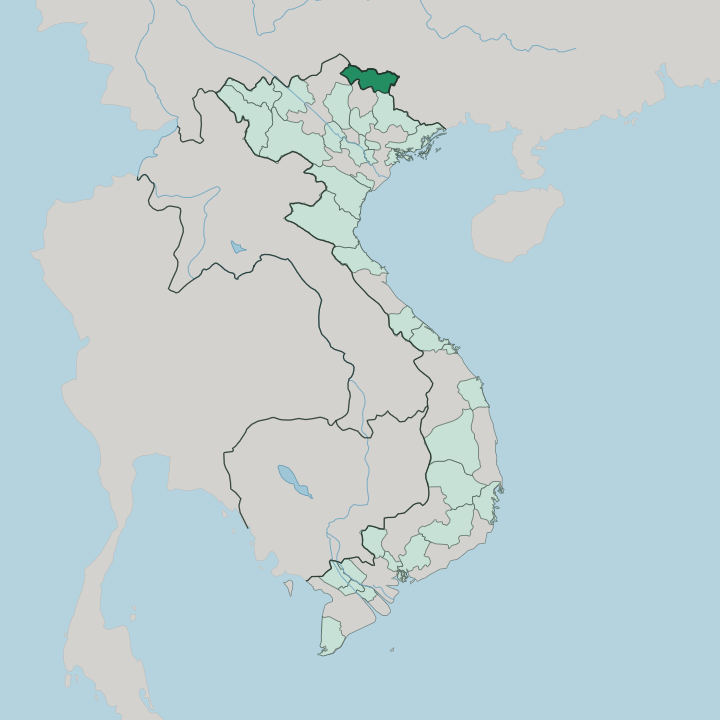


Towns & cities in Tỉnh Cao Bằng
Pick a town or city — each links to where to stay.
Most trips start in Cao Bằng city. The main town sits where the Bằng and Hiến rivers meet, and it holds the walking street, the bus station and nearly all the province's hotels. From there the sights are day trips or overnight runs into the karst.
For the waterfall, travellers overnight at Tày stone-house homestays in Khuổi Ky village near Bản Giốc, though the border zone needs a permit arranged in advance. Pick the city for comfort and connections; pick a valley homestay when you want to wake among the limestone peaks.
About Tỉnh Cao Bằng
Bản Giốc Waterfall is the draw.
What is Tỉnh Cao Bằng known for?
The broad, tiered cascade drops over karst cliffs on the Quây Sơn River, shared between Cao Bằng and Guangxi across the frontier with China. Inland, the limestone country of the Non Nước Cao Bằng UNESCO Global Geopark holds cave systems like Ngườm Ngao, turquoise river pools and the lake cluster of Thang Hen. Cao Bằng is also revolutionary ground: at Pác Bó, Hồ Chí Minh set up his first base on returning to Vietnam in 1941.
Tày and Nùng villages farm the valleys between the peaks.
Where is Tỉnh Cao Bằng?
Cao Bằng fills the far north-east of Vietnam. A highland province, it is pressed against the Chinese frontier, where Guangxi lies across more than three hundred kilometres of border to the north and east. Inside Vietnam it meets Lạng Sơn to the south-east, Thái Nguyên to the south and Tuyên Quang in the west.
The ground here rears up and slopes away. Rivers have cut its limestone plateau into a maze of karst towers, sinkholes and blind valleys, and the highest ground rises in the west at forested Phia Oắc. Water defines the province.
The Bằng River rises here and runs down past Cao Bằng city, where the Hiến joins it before both flow on toward the Chinese border. Further east the Quây Sơn River spills over a limestone shelf to form Bản Giốc Waterfall, the wide curtain of cascades shared with China. Much of this country lies inside the Non Nước Cao Bằng UNESCO Global Geopark.
Its karst hides river caves like Ngườm Ngao and the linked Thang Hen lakes, which rise and fall with the seasons. Rice terraces and maize fields fill the valley floors between the peaks.
What is Tỉnh Cao Bằng like?
This is Tày and Nùng country. Together those two groups make up most of the province, farming the valleys from wooden stilt houses and weaving the indigo-dyed brocade sold at rotating village markets. Hmong and Dao families live higher up, on the ridges and forest slopes.
The Lồng Tồng field festival opens the farming year with songs and games on the terraces. Vietnamese is the shared language, but Tày and Nùng are spoken across the countryside. Music carries the culture.
The Then singing of the Tày and Nùng, performed to the plucked tính lute, is recognised by UNESCO as intangible heritage and still sounds at weddings and temple rites. Kỳ Sầm Temple honours Nùng Trí Cao, the Nùng lord who led an eleventh-century revolt against the Vietnamese court. The kitchen leans local too.
Cao Bằng is known for its rolled bánh cuốn eaten in broth, the sweet chestnuts of Trùng Khánh, and khâu nhục, a slow-braised pork dish borrowed from just over the Chinese border. Sunday markets like the one at Trùng Khánh draw in growers from the surrounding hamlets to trade produce and livestock.
What is the history of Tỉnh Cao Bằng?
Cao Bằng has long been a frontier. Upland Tai chiefs held it in antiquity, and in the eleventh century the Nùng lord Nùng Trí Cao led a revolt here against the Vietnamese throne. When the Mạc dynasty lost Hà Nội in 1592, its court fled north and ruled on from Cao Bằng for three more generations.
Its most famous chapter is modern. At Pác Bó, near the border, Hồ Chí Minh returned from exile in 1941 and founded the Việt Minh, making the province a cradle of the independence struggle. A century of French rule and the scars of the 1979 war with China both left their mark.
What is the climate of Tỉnh Cao Bằng?
Cao Bằng runs on the monsoon. Summers are hot and wet, when the heaviest rains swell the Quây Sơn River and Bản Giốc Waterfall reaches its fullest, thundering brown across the border ledge. Winters turn cool and dry.
Cold air spilling off the Chinese highlands can bring frost and thick mist to the karst peaks, and the summit forests of Phia Oắc stay chilly even in the heat. Autumn is the clear season, when the rice ripens gold and the rivers run their brightest jade.
How do you get to Tỉnh Cao Bằng?
There is no airport and no train. Nearly everyone comes by road from Hà Nội, a run of roughly two hundred and eighty kilometres that climbs north through Thái Nguyên and over the Cao Bắc pass. Sleeper buses leave the Hà Nội terminals through the day.
From Cao Bằng city, local roads carry on east to Bản Giốc and the Quây Sơn River, though the frontier strip needs a permit arranged before an overnight stay. The Tà Lùng and Trà Lĩnh gates cross into Guangxi.
Good for
Updated July 2026