Vietnam
Tỉnh Lai Châu, Vietnam — Towns & Travel Guide


Lai Châu is a mountainous province in Vietnam's far north-west, a border land of the Black River and the peaks of the Hoàng Liên Sơn.
About Tỉnh Lai Châu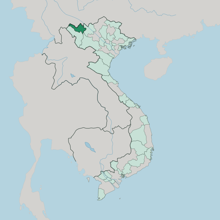


Towns & cities in Tỉnh Lai Châu
Pick a town or city — each links to where to stay.
Base yourself in the valley towns. The provincial seat of Lai Châu sits in the Tam Đường valley below the Pu Ta Leng ridge, and it holds most of the province's hotels and bus links. Higher up, the Sìn Hồ plateau trades comfort for cool air and ethnic homestays.
Beyond that, roads thin out. Choose Lai Châu town for a first base, Sìn Hồ if you want the highland cold, and Mường Tè only when the upper Black River is your aim.
About Tỉnh Lai Châu
Altitude sets the tone here.
What is Tỉnh Lai Châu known for?
Fansipan, the highest peak in Vietnam and the roof of the Indochinese peninsula, rises on the province's eastern rim, shared with neighbouring Lào Cai across the Hoàng Liên Sơn range. The Sìn Hồ plateau climbs above the valleys, cool enough to be called a second Sa Pa. Tea terraces cover the lower hills.
Its real draw is people, though: more than twenty ethnic groups, with Thái and Hmong villages holding weekly markets that colour the mountain towns.
Where is Tỉnh Lai Châu?
Lai Châu occupies the far north-west corner of Vietnam, a block of high mountains and deep valleys pressed against the Chinese province of Yunnan along its whole northern frontier. Three provinces ring the rest. Lào Cai lies to the east, and Điện Biên and Sơn La close the southern side.
Fansipan, the highest summit in Vietnam, stands on that eastern boundary within the Hoàng Liên Sơn range. This is some of the most rugged, thinly settled ground in the country. The Black River, the Đà, is the province's great artery, gathering the Nậm Na and Nậm Mu out of the ranges before it is dammed for hydropower near Nậm Hàng.
Little of it lies flat. The Sìn Hồ plateau rides high above the Nậm Na, terraced and cold, one of several tablelands folded into the interior. Westward the land climbs again toward Mường Tè, the remotest district, where the Black River enters from China.
Roads cross the Ô Quy Hồ pass toward Sa Pa, then fall back to the valley floors. Much of the province stands well above the lowlands, a highland shelf tilted toward the Red River delta far to the south-east. The Yunnan border seals the top.
What is Tỉnh Lai Châu like?
Lai Châu is one of the most ethnically varied provinces in Vietnam. More than twenty groups share its valleys and ridges. The Thái are the largest, split between Black Thái in the southern valleys and White Thái further north, both living in stilt houses along the rivers and farming wet rice on terraced slopes.
Hmong and Dao hamlets hold the higher ground. Kinh from the lowlands are a minority here. Textiles carry meaning too, each group's patterns and indigo dyeing marking who the wearer is and where the village stands.
Weekly markets are the social heartbeat. At Sìn Hồ and Dào San, mountain villagers gather to trade indigo cloth, herbal medicine and buffalo, the women in silver jewellery and embroidered dress. Ancestor worship and mountain-spirit rites run through Thái life.
Gongs sound at festivals. The Hà Nhì of Mường Tè keep their own new-year rituals in the far west, near the Yunnan line. Terraced rice defines the working landscape, cut into the hillsides above the Nậm Na and flooded silver each planting season.
Roads reached many hamlets late, and the old crafts held on because of it.
What is the history of Tỉnh Lai Châu?
Lai Châu was long a Tai world. Its valleys formed the heart of the Sip Song Chau Tai, the Twelve Tai Cantons ruled by White Tai lords from Mường Lay on the Black River. In 1889 the lord Đèo Văn Trị signed a treaty with the French explorer Auguste Pavie, and the cantons passed under French protection.
France went further in 1948, proclaiming a Tai Federation with Lai Châu as its capital. It did not last. The Geneva accords of 1954 dissolved the federation, and Điện Biên was later carved off to the south in 2004.
What is the climate of Tỉnh Lai Châu?
In Lai Châu it is height that sets the climate. Lai Châu has a humid subtropical climate, but height pulls it cooler than the Vietnamese lowlands, and the seasons split hard between a wet summer and a dry winter. The south-west monsoon soaks the ranges from spring to autumn.
Winters run dry and cold. On the Sìn Hồ plateau frost forms in the cold months, and mist can bring all four seasons to a single day. Down in the Black River valleys the air stays warmer.
How do you get to Tỉnh Lai Châu?
Lai Châu has no airport and no railway. Everything arrives by road. The usual approach is the long climb from Hà Nội through Sơn La, or the shorter, higher crossing from Sa Pa and Lào Cai over the Ô Quy Hồ pass.
Sleeper buses run overnight from Hà Nội's My Đình station. The mountain roads climb slow and winding. Many travellers pair the province with Sa Pa, dropping over the pass by car or motorbike into the Tam Đường valley.
Good for
Updated July 2026