Vietnam
Tỉnh Ðiện Biên, Vietnam — Towns & Travel Guide


Điện Biên anchors Vietnam's far-northwest frontier. Its Mường Thanh valley holds the 1954 Điện Biên Phủ battlefield beside the border with Laos.
About Tỉnh Ðiện Biên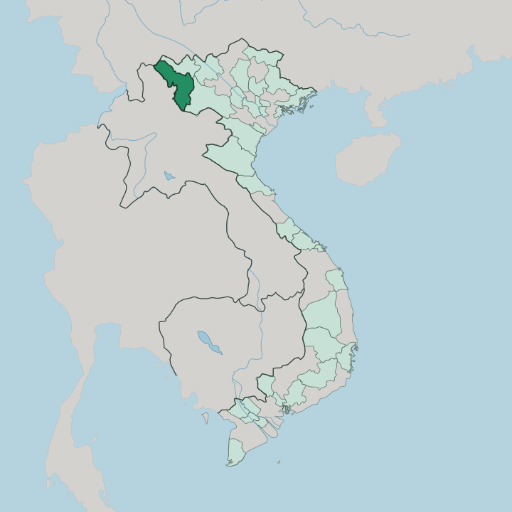


Towns & cities in Tỉnh Ðiện Biên
Pick a town or city — each links to where to stay.
Almost every visit starts in Điện Biên Phủ. The town sits on the flat floor of the Mường Thanh valley, within walking reach of Hill A1, the command bunker, and the region's main airport. Two quieter bases lie nearby.
East of town, forest rings Pá Khoang lake and the Mường Phăng clearing, where General Giáp ran the 1954 campaign from a bamboo hut. Choose the city for the battlefield; pick Mường Lay, up on the Đà river, for White Thái stilt houses.
About Tỉnh Ðiện Biên
One battle made the name.
What is Tỉnh Ðiện Biên known for?
In the spring of 1954, Việt Minh troops under Võ Nguyên Giáp overran the French garrison dug into the Mường Thanh valley, and the fifty-six-day siege of Điện Biên Phủ ended French rule across Indochina. The old battlefield is the province's magnet: Hill A1, the shell-scarred French command bunker, and the Victory Monument above the town. Beyond the war, the valley is the largest rice basin in Vietnam's northwest.
Thái and Hmong markets fill its edges.
Where is Tỉnh Ðiện Biên?
Điện Biên occupies the far north-western corner of Vietnam, the last province before the country runs out into Laos and China. It is the only Vietnamese province that touches both neighbours. Laos lies along the western and southern rim, where the Tây Trang gate crosses into Phongsaly, while the Chinese province of Yunnan closes off a short stretch of the north.
Inland, Lai Châu adjoins it to the north-east and Sơn La to the south-east. The land is nearly all mountain. Ranges of the Northwest run in long parallel folds, cut by narrow river gorges, and the province climbs past ridgelines above a thousand metres before dropping into a handful of flat basins.
The largest of those basins is Mường Thanh. Roughly twenty kilometres long and shaped like a splayed heart, it carries the Nậm Rốm river and the richest paddy in the northern uplands. That river is a clue to something unusual.
Water from the Mường Thanh side drains south-west through the Nậm Rốm into Laos and on to the Mekong, while the province's eastern slopes shed their streams the other way, toward the Đà river and the Red River. Điện Biên Phủ, the largest town, stands on the valley floor. The Pha Đin pass guards the eastern approach, thirty kilometres of switchbacks on the road down to Sơn La.
What is Tỉnh Ðiện Biên like?
The valley floor belongs mostly to the Thái, and the hills above it to the Hmong. Between them these two peoples make up more than seven in ten of the province, far outnumbering the Kinh lowlanders who run the towns. Smaller communities of Khơ Mú and Dao hold the middle slopes.
Each keeps its own dress, language, and calendar. Thái families live in wooden stilt houses gathered around the paddy, weaving brocade on hand looms and passing round rượu cần, the rice wine drawn up through long bamboo straws. Above the fields, Hmong hamlets cling to the ridgelines.
Their new-year festivals, silver jewellery, and embroidered indigo cloth are unmistakable on a market morning. Music binds all of it. The circle dance of the Thái, the xòe, moves hand-in-hand around a fire and carries a UNESCO listing of its own.
Food leans smoky and dried: buffalo meat cured over the kitchen hearth as thịt trâu gác bếp, grilled river fish, and sticky rice pressed by hand. The war sits inside the culture too, marked every spring when the town fills for the victory anniversary.
What is the history of Tỉnh Ðiện Biên?
Tai settlers named the valley Mường Thanh, the land of heaven, and farmed its paddy for centuries. The Nguyễn dynasty made Điện Biên a formal district in 1841, chiefly to police the opium trade along the Lao frontier. Then came the reckoning.
In the spring of 1954 the Việt Minh besieged and destroyed the French garrison in the valley, ending nearly a century of French Indochina. A colonial decree of 1909 had first drawn the surrounding province; the borders shifted again in 2004, when Điện Biên split from Lai Châu to stand alone.
What is the climate of Tỉnh Ðiện Biên?
Điện Biên's year falls into just two seasons. The southwest monsoon soaks the mountains from May into September, swelling the Nậm Rốm and loosening the earth on the passes until landslides close the road. Mist is the constant.
It pools on the Mường Thanh floor most mornings, then burns off as the valley heats. Winter turns dry and dusty, cool by day and genuinely cold after dark up on the Pha Đin ridge, where the height keeps summers milder than the delta lowlands far to the east.
How do you get to Tỉnh Ðiện Biên?
The airport does most of the work. Điện Biên Phủ's runway sits at the valley's edge, a short hop from Hanoi and the only scheduled air link in Vietnam's northwest. By road it is a haul. Roughly five hundred kilometres of National Highway 6 climb west from Hanoi, up through Sơn La and over the Pha Đin pass, before the last stretch drops into the Mường Thanh floor.
No railway comes near. Drivers heading further west can leave the country at the Tây Trang gate, which crosses into Laos toward Phongsaly.
Good for
Updated July 2026