Democratic Republic of the Congo
Bas Uele, Democratic Republic of the Congo — Towns & Travel Guide


Bas-Uélé is a forest-and-savanna province in the far north of the Democratic Republic of the Congo, named for the Uélé River that drains it.
About Bas Uele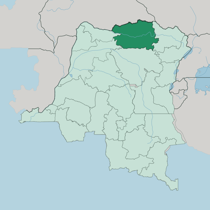


Towns & cities in Bas Uele
Pick a town or city — each links to where to stay.
Buta is the practical base. As the provincial capital on the Rubi River, it holds what few guesthouses and government lodgings the province has, and it is where the Buta Zega airstrip and the old Vicicongo rail line converge. Bondo, on the north bank of the Uélé, anchors the far north and serves as the jumping-off point for the Bili Forest.
Aketi sits east on the Itimbiri, the river-and-rail town that once moved the region's freight. If you want the capital and its connections, choose Buta; if you are heading for the Uélé and the deep forest, base yourself at Bondo instead.
About Bas Uele
Bas-Uélé is remote.
What is Bas Uele known for?
It fills a broad northern corner of the Democratic Republic of the Congo, a mosaic of rainforest and open savanna that few outsiders ever cross. The Uélé River, which gives the province its name, winds west across the whole territory before feeding the Mbomou near the Central African Republic. Buta is the provincial capital, set on the Rubi River, and the point most business and travel routes through.
The Azande are the largest people here, and much of daily life turns on farming, hunting, and river trade rather than roads.
Where is Bas Uele?
Bas-Uélé occupies the far north of the Democratic Republic of the Congo, a landlocked block of about 148,331 square kilometres of forest and savanna. The Uélé River runs the length of it. That river gives the province its name, threading west across the whole territory before it joins the Mbomou at Yakoma, downstream from here.
To the north, the Mbomou itself draws the frontier with the Central African Republic, and South Sudan presses against the province's north-eastern edge. The land is mostly plateau. In the south the ground drops toward the marshy lowlands of the Congo Basin, and dense rainforest closes in; further north the trees thin and savanna takes over.
Buta, the capital, does not sit on the Uélé at all. It stands instead on the Rubi River, a tributary of the Itimbiri, in the province's southern reaches. Bondo lies well to the north on the Uélé, near the Bomu Wildlife Reserve that stretches along the border river.
The province is split by water more than by any drawn line, and the rivers, not roads, still set the shape of how people move.
What is Bas Uele like?
The Azande are the people of Bas-Uélé. Long before Belgium mapped the region, they migrated into the Uélé country and became its dominant group, and their language is still heard across the province alongside Lingala and official French. Others share the land with them.
The Boa, Makere, and smaller communities farm the same forest edges and river flats, and the province carries a patchwork of tongues rather than a single one. Life here is rural and river-bound. Most households live by subsistence farming and hunting, supplemented by the trade that moves up and down the Uélé and the Rubi by canoe and small boat.
The Zande are known across central Africa for their oral tradition, their music, and a body of belief and craft that anthropologists have studied for a century. Cathedrals and mission schools in Buta mark the long Catholic presence left by the colonial era. Away from that town, culture is carried in villages strung along the water, in fields cut from the forest, and in the markets where the river brings people together.
What is the history of Bas Uele?
Bas-Uélé is young as a province but old as a district. The Belgian administration carved a Bas-Uele District out of the wider Uele country in 1912, and Buta grew as its administrative and rail centre once the Vicicongo narrow-gauge line reached the town in 1931. Then independence came.
For decades after it, the district was folded into the sprawling Orientale Province. That changed in 2015, when the Democratic Republic of the Congo broke Orientale apart into four, and Bas-Uélé emerged as a province in its own right with Buta elevated to capital.
What is the climate of Bas Uele?
Bas-Uélé is hot and wet. It sits deep in equatorial central Africa, so the year divides into rainy stretches and shorter drier spells rather than into hot and cold seasons. Buta, in the forested south, has a tropical savanna rhythm, while the far north around Bondo runs to a wetter monsoon pattern.
Heavy rain is the rule for much of the year, and it is that rain, soaking the earth tracks into swamp, that cuts the province off by road for weeks at a time. The forest stays green throughout.
How do you get to Bas Uele?
Reaching Bas-Uélé is hard. The surest way in is by air to Buta Zega, the capital's airstrip, which carries small scheduled flights south to Kisangani on the Congo River. Going overland is punishing: the road from Kisangani to Buta runs roughly 325 kilometres, crosses the Aruwimi at Banalia, and dissolves into swamp along the way, so a trip that should take hours can stretch to days.
The old Vicicongo railway that once linked Buta to Aketi on the Itimbiri no longer offers dependable passenger service. For most travellers, the plane to Buta is the only realistic door into the province.
Good for
Updated July 2026