Democratic Republic of the Congo
Province du Nord-Ubangi, Democratic Republic of the Congo — Towns & Travel Guide


Province du Nord-Ubangi lines the Ubangi River in the far north-west of the Democratic Republic of the Congo, its capital Gbadolite.
About Province du Nord-Ubangi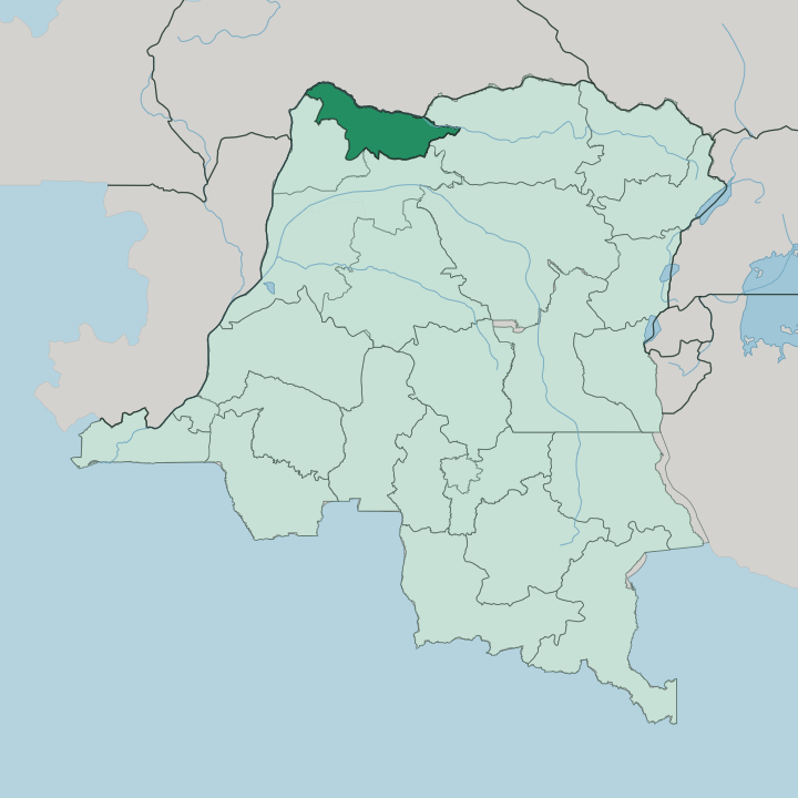


Towns & cities in Province du Nord-Ubangi
Pick a town or city — each links to where to stay.
Base yourself in Gbadolite. It is the provincial capital and the one town with an airport, a hospital and the ruined palaces travellers come to see. Beyond it the province thins fast into four rural territories.
Businga sits on the road south toward the old Équateur heartland, Bosobolo lies inland away from the river, and Mobayi-Mbongo guards the dam upstream. Yakoma holds the eastern corner where the Uele and the Bomu meet to form the Ubangi. Stay in Gbadolite; the territories are for passing through, not sleeping in.
About Province du Nord-Ubangi
One name defines this province.
What is Province du Nord-Ubangi known for?
Gbadolite was the ancestral home of Mobutu Sese Seko, who poured a fortune into it and left behind the palace complex outsiders came to call the Versailles of the Jungle. His airport was built long enough to land a Concorde, and a hydroelectric dam still turns on the Ubangi River at Mobayi-Mbongo. The river itself is the other headline, drawing the border with the Central African Republic along the province's whole northern edge.
Where is Province du Nord-Ubangi?
Nord-Ubangi occupies the far north-west of the Democratic Republic of the Congo, a broad wedge of land pressed against the Ubangi River. The river is everything here. It runs along the entire northern boundary and separates the province from the Central African Republic on the far bank, and near Yakoma it is born where the Uele and the Bomu rivers join.
Gbadolite, the capital, stands a short way back from the water, roughly a dozen kilometres south of it. Kinshasa is very far off. The national capital lies some 1,150 kilometres to the south-west, a distance that leaves this corner of the country isolated by any road. The land itself belongs to the Congo Basin.
Wooded savanna covers the higher ground and gives way to denser rainforest as the terrain drops toward the river valley. Sud-Ubangi lies immediately downstream to the west, Mongala to the south, and the reshaped Équateur province beyond that. Low plains and gentle rises make up most of the relief, and the many streams draining north into the Ubangi shape the settlement pattern more than any hill ever could.
What is Province du Nord-Ubangi like?
This is Ngbandi country. The Ngbandi are the province's defining people, and Mobutu, born of them, drew his own name and self-image from these riverside communities. Alongside them live the Mbaka, the Banda and the Banziri, farmers and fishers whose villages string along the tracks between the territories.
French is the official language of administration, but Lingala is the tongue of the market and the road, and Ngbandi is still spoken at home across the villages. Life runs to the rhythm of the river and the fields. Cassava, plantain and river fish feed most households, and dugout canoes remain the honest way to cross the Ubangi.
The palaces at Gbadolite haunt the province's sense of itself. For a couple of decades they made this remote place the second seat of a nation, flying in marble and chandeliers to the edge of the forest, and their looted shells are now half-swallowed by returning bush. Music and Sunday worship carry weight everywhere.
What endures is a strong local identity, proud and rural, shaped far more by the water and the land than by anything in distant Kinshasa.
What is the history of Province du Nord-Ubangi?
Nord-Ubangi is young as a province. It was carved out in 2015, when the old Équateur province was dismembered into five, and this northern slice took Gbadolite as its capital. That town carried the deeper story.
It rose from an ordinary village to a presidential city under Mobutu Sese Seko, whose regime fell in 1997 to Laurent-Désiré Kabila's advance, after which the palaces were stripped and the airport left to grass. The province simply gave a formal border to a place already famous for one man's rise and ruin.
What is the climate of Province du Nord-Ubangi?
The climate is hot and tropical the year round. Sitting in the Congo Basin near the equator, the province stays warm and humid, with days pushing past thirty degrees under a heavy sky. A long rainy season runs roughly from September to May and can turn the red-earth tracks to mud, while a shorter drier spell breaks it around the middle of the year.
Storms build over the Ubangi in the afternoons. Rain, not cold, sets the calendar here.
How do you get to Province du Nord-Ubangi?
Getting here takes effort. The province lies about 1,150 kilometres from Kinshasa across country with few paved roads, so most travellers arrive by air into Gbadolite Airport, the outsized runway Mobutu built to receive a Concorde. Flights are the reliable link.
The Ubangi River offers the other route, with barges and dugouts working the water that separates Nord-Ubangi from the Central African Republic. Overland journeys from the south are long, seasonal and slow, hostage to the rains that swallow the tracks for months.
Updated July 2026