Mexico
Estado de Coahuila de Zaragoza, Mexico — Towns & Travel Guide


Coahuila de Zaragoza is Mexico's third-largest state, a high desert reaching from the Sierra Madre Oriental to the Rio Grande border with Texas.
About Estado de Coahuila de Zaragoza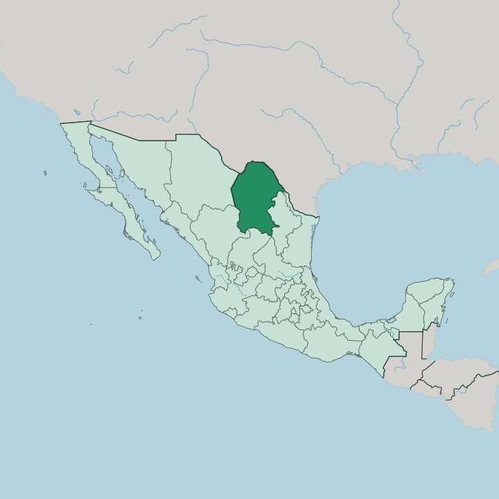


Towns & cities in Estado de Coahuila de Zaragoza
Pick a town or city — each links to where to stay.
Saltillo is the natural first base, the capital set in the Sierra Madre Oriental foothills with the Museo del Desierto and its dinosaur halls on the city's western edge. Torreón anchors the Laguna. For wine, Parras de la Fuente gathers vineyards and spring pools around the Casa Madero cellars below the mountains.
Cuatro Ciénegas lies further into the desert, a small town beside the turquoise pools of its basin. Pick Saltillo for a first visit; go west for wine and the desert water.
About Estado de Coahuila de Zaragoza
What is Estado de Coahuila de Zaragoza known for?
Coahuila is Mexico's third-largest state, a sweep of Chihuahuan Desert and mountain in the country's north. Saltillo is the capital. Torreón anchors the cotton-growing Comarca Lagunera to the south-west, while the turquoise spring pools of Cuatro Ciénegas draw biologists and swimmers into the desert basin.
Parras de la Fuente grows the grapes for Casa Madero, the oldest winery in the Americas. Saltillo's Museo del Desierto holds one of the country's great collections of dinosaur fossils.
Where is Estado de Coahuila de Zaragoza?
Coahuila is the third-largest of Mexico's states, filling a broad wedge of the country's north against the border with Texas. Its northern edge follows the Rio Grande, the river Mexicans call the Río Bravo del Norte, for a long stretch of the line dividing the two countries. Nuevo León lies to the east and Zacatecas to the south. Durango and Chihuahua share the western frontier. The Sierra Madre Oriental crosses the state from the north-west toward the south-east, and its northern spurs, the Sierra del Carmen and the Sierra del Burro, run right up to the Rio Grande.
Two landscapes divide it. West of the Sierra Madre lies desert, part of the great Chihuahuan Desert that runs down from the United States. Within that dry country, west of Monclova, the spring-fed pools and gypsum dunes of the Cuatro Ciénegas basin form a wetland found nowhere else.
The east is different. Cooler, moister highlands gather most of the state's people in and around Saltillo. Perennial rivers barely reach the desert west, which is why the spring water of Cuatro Ciénegas matters so much.
What is Estado de Coahuila de Zaragoza like?
Coahuila keeps the culture of Mexico's northern desert, built on cattle ranching, mining, and the wide frontier that faces Texas across the Rio Grande. The sarape de Saltillo grew out of that world, a finely woven wool blanket whose banded colours became a symbol of the whole country. Spanish is the language spoken throughout.
Norteño music, grilled cabrito, and the vaquero horseback traditions of the ranches all belong to the same northern grain. The desert itself shapes daily life, from the adobe towns of the west to the ranches strung along the dry watercourses. Wine gives the state a second, older thread.
Parras de la Fuente has pressed grapes since the end of the sixteenth century, and each August the town fills for its grape harvest festival. Torreón and the Comarca Lagunera built their wealth on cotton and dairy, a different economy from the ranch country and the vineyards. Industry runs alongside the vineyards.
Monclova forges steel at one of the largest ironworks in the country, and car plants cluster around Saltillo. Near Múzquiz, the Kickapoo community keeps its own language and customs at the settlement of El Nacimiento, a people who crossed south from the plains of the United States generations ago.
What is the history of Estado de Coahuila de Zaragoza?
Spanish settlers founded Saltillo in 1577, one of the oldest towns in the Mexican north. After independence, the new republic joined this land with its northern neighbour as the single state of Coahuila y Tejas in 1824, an arrangement that lasted only until Texas broke away in 1836. Coahuila later shaped the nation directly.
Venustiano Carranza, born at Cuatro Ciénegas, raised the Constitutionalist army here during the Mexican Revolution and went on to the presidency.
What is the climate of Estado de Coahuila de Zaragoza?
Most of Coahuila is dry. The western desert bakes under hot summers and turns cold on winter nights, the pattern of the Chihuahuan Desert, which sees more of its rain from summer thunderstorms than the deserts further west. Elevation softens the extremes in the east.
Saltillo sits high in the Sierra Madre Oriental and stays cooler and greener than the Laguna lowland around Torreón, where the heat builds hardest. Snow is rare but not unknown on the higher ranges.
How do you get to Estado de Coahuila de Zaragoza?
Saltillo keeps its own airport, the Plan de Guadalupe out at Ramos Arizpe, while Torreón is served by the Francisco Sarabia field across the Laguna plain to the west. Many drive in instead. The most common land route comes down from Texas, crossing the Rio Grande at the border cities of Piedras Negras and Ciudad Acuña.
Others use the larger airport at Monterrey, an hour east in Nuevo León. Inside the state, federal highways tie Saltillo, Monclova, and Torreón across the desert.
Good for
Updated July 2026