Thailand
Changwat Nan, Thailand — Towns & Travel Guide


Nan is a mountainous province in the far north of Thailand, wrapped around the upper Nan River against the border with Laos.
About Changwat Nan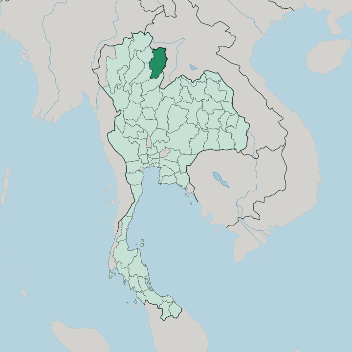


Towns & cities in Changwat Nan
Pick a town or city — each links to where to stay.
Most visitors base themselves in Nan city, the old riverside capital, treating everything else as a day out. The town is small. Its lanes hold the murals of Wat Phumin, a walkable night market, and the former palace of the ruling princes, all within a few minutes of the Nan River.
North of the city, Pua spreads across a valley of rice terraces below Doi Phu Kha, where Tai Lue weaving villages and a hillside cocoa farm make an unhurried second base. Push further east into the folded mountains to reach Bo Kluea, a remote valley where wooden pans still boil salt from inland brine wells. Base in the old town first; keep Pua and Bo Kluea for slower days.
About Changwat Nan
What is Changwat Nan known for?
Nan is Thailand's far-northern outlier, long cut off from the rest of the country by the mountains that ring its river valley. Temples set the tone. Wat Phumin, a cruciform hall raised in 1596, holds the murals that draw most first-time visitors, while the gilded chedi of Wat Phra That Chae Haeng stands guard on a rise across the Nan River.
Beyond the old town the province turns wild, climbing into Doi Phu Kha National Park and out to the mountain salt wells of Bo Kluea. Its people carry a Tai Lue inheritance of weaving and quiet ritual that sets Nan apart from lowland Siam.
Where is Changwat Nan?
Nan lies in the far north of Thailand, wrapped around the upper Nan River where the country presses against Laos. The river is its spine. It rises in the Luang Prabang Range along the eastern rim and runs the length of the province southward, gathering the valley's streams before leaving to join the Chao Phraya far downstream near Nakhon Sawan.
Forested mountains wall the basin on every side, the Phlueng Range closing it off to the west and the Luang Prabang Range dividing it from Laos to the east. Woodland still covers most of the province. The highest of these summits, Phu Khe, rises above 2,000 metres in the remote district of Bo Kluea.
Land borders box the province in on three sides. Laos lies along the north and the east, beyond the ridgeline, while Uttaradit sits to the south, Phrae to the south-west, and Phayao over the hills to the west. This is dead-end country.
No through-route carries traffic onward into Laos here, so the valley has kept the inward-looking character that its mountains forced on it. Rivers, not roads, shaped how Nan grew.
What is Changwat Nan like?
Nan grew up apart, and its culture shows the long isolation. The dominant thread is Tai Lue. These are a Tai people who drifted south from Sipsongpanna in Yunnan and settled the valley, bringing loom traditions, temple forms, and a Buddhism of their own inflection.
Their weavers are known for lai nam lai, a flowing-water pattern worked into indigo cloth that still turns up in the markets around the old town. Over the centuries that Tai Lue base fused with the Lanna traditions of the wider north, and out of the blend came a distinct local school of temple art. Nan does its own thing.
Faith anchors the year. The province's holiest site, Wat Phra That Chae Haeng, crowns a low hill across the river, its gilded chedi ringed by a serpent balustrade in the Nan manner, and pilgrims climb to it at the winter festival. Inside Wat Phumin, painted figures whisper across the walls in the mural that Nan is loved for, a courting couple leaning close in nineteenth-century dress.
The uplands belong to other peoples too, Hmong and Mien and Htin, and the small forest-dwelling Mlabri. When the rains end, long crewed boats race on the Nan River, and the whole town comes down to the water. It is a province that rewards slowness.
What is the history of Changwat Nan?
Nan began as an independent mueang, founded by the Phukha dynasty around the settlement of Pua in the late 13th century before its rulers shifted the seat downriver to the present city. For a while it stood among the Tai principalities of the north, tied into Lanna and known as Chiang Klang, the 'middle city' between Chiang Mai and the golden city now called Luang Prabang. Then came Burma.
Burmese armies seized the kingdom in 1558 and carried off much of its population, and Nan was left half-empty until the north was won back in 1786. Its own princes ruled on under the crown at Bangkok, semi-autonomous, right up to 1931, when the old principality was folded fully into Siam.
What is the climate of Changwat Nan?
Nan runs on the monsoon calendar of the tropical north, split into three plain seasons. The cool months from November hold the year's best weather, when clear mornings settle over the valley and mist pools in the high folds around Doi Samer Dao. Heat builds through March and April until the air over the basin turns heavy and hazy.
Then the rains break. The south-west monsoon soaks the province from May into October, greening the rice terraces, swelling the Nan River, and washing out the rougher mountain tracks for weeks at a time. Altitude tempers it all, and the ridges stay markedly cooler than the valley floor.
How do you get to Changwat Nan?
Getting to Nan takes effort, which is much of the point. The quickest way in is to fly. Nan Nakhon Airport, a small strip just outside the city, links the province to Bangkok on short daily hops, sparing travellers the long haul overland.
By road it is a different commitment: a full day's drive north from Bangkok, or a shorter mountain run from Chiang Mai that climbs over the ranges by way of Phrae. Buses grind up the same routes. Once inside the province, a car earns its keep, since the switchback roads out to Doi Phu Kha and Bo Kluea are the only way to reach the high country.
Good for
Updated July 2026